
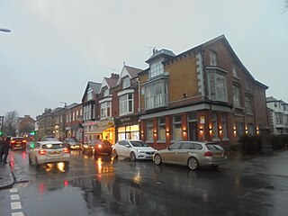
Boston is a market town with a port on the east coast of England in Lincolnshire, about 100 miles (160 km) north of London. It is the largest town of the wider Borough of Boston local government district. The town had a population of 35,124 at the 2001 census, while the borough had a population of 66,900 at the ONS mid-2015 estimates. It is north of Greenwich on the Prime Meridian.

George Bancroft was an American historian, statesman and Democratic politician who was prominent in promoting secondary education both in his home state and at the national and international levels.
Boston Spa is a village and civil parish in the City of Leeds metropolitan borough in West Yorkshire, England. Situated 3 miles (5 km) south of Wetherby, Boston Spa is on the south bank of the River Wharfe which separates it from Thorp Arch. According to the 2001 census the parish had a population of 4,006 rising to 4,079 in the 2011 census.

The River Witham is a river almost entirely in the county of Lincolnshire in the east of England. It rises south of Grantham close to South Witham at SK8818, passes through the centre of Grantham, passes Lincoln at SK9771 and at Boston, TF3244, flows into The Haven, a tidal arm of The Wash, near RSPB Frampton Marsh. The name "Witham" seems to be extremely old and of unknown origin. Archaeological and documentary evidence shows the importance of the Witham as a navigable river from the Iron Age onwards. From Roman times it was navigable to Lincoln, from where the Fossdyke was constructed to link it to the River Trent. The mouth of the river moved in 1014 following severe flooding, and Boston became important as a port.

Witham is a town in the county of Essex in the East of England, with a population of 25,353. It is part of the District of Braintree and is twinned with the town of Waldbröl, Germany. Witham stands between the city of Chelmsford and the town of Colchester, on the Roman road between the two. The River Brain runs through the town and joins the River Blackwater just outside.
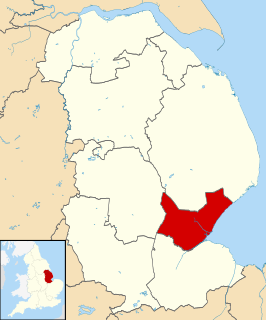
The Borough of Boston is a local government district with borough status in Lincolnshire, England. Its council is based in the town of Boston.

Fitzroy North is an inner-city suburb of Melbourne, Victoria, Australia, 4 km north-east of Melbourne's Central Business District. Its local government area are the cities of Yarra and Moreland. At the 2011 Census, Fitzroy North had a population of 11,473.

Wombwell is a town in the Metropolitan Borough of Barnsley in South Yorkshire, England. The town in the 2011 census was split between a ward called Wombwell, as well as small parts that fell under two other wards called Darfield and Stairfoot. Added together, these list the town's population as roughly 15,316.

West Roxbury is a neighborhood in Boston, Massachusetts bordered by Roslindale to the northeast, the town of Brookline to the north, the city of Newton to the northwest and the town of Dedham to the southwest. West Roxbury is often mistakenly confused with Roxbury, but, by around 6 miles, the two are not connected. West Roxbury is separated from Roxbury by Jamaica Plain and Roslindale.

Waddington is a village and civil parish in the North Kesteven district of Lincolnshire, England, situated approximately 4 miles (6 km) south of Lincoln on the A607 Grantham Road. The village is known for its association with RAF Waddington. At the 2001 Census Waddington had a population of 6,086, increasing to 6,122 at the 2011 census.

The Haven is the tidal river of the port of Boston, Lincolnshire in England. It provides access for shipping between Boston Deeps in The Wash and the town, particularly, the dock. It also serves as the outfall into the sea, of the River Witham and of several major land drains of the northern Fens of eastern England, which are known collectively as the Witham Navigable Drains..
St Julians is an electoral district (ward) and coterminous community of the City of Newport, South Wales.

The Priory Academy LSST is a co-educational partially-selective academy school and teaching school situated on Cross O'Cliff Hill, Lincoln, Lincolnshire, England. It specialises in science, technology and teaching, and is the lead school of the Lincolnshire Teaching Schools Alliance. It is also the lead member of The Priory Federation of Academies.
Boston was a parliamentary borough in Lincolnshire, which elected two Members of Parliament (MPs) to the House of Commons from 1547 until 1885, and then one member from 1885 until 1918, when the constituency was abolished.
Maltings Academy is a secondary school in Witham, Essex, it is the larger of two secondary schools in Witham. It is a relatively new school as it is a replacement for the John Bramston School.
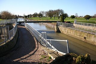
The Witham Navigable Drains are located in Lincolnshire, England, and are part of a much larger drainage system managed by the Witham Fourth District Internal Drainage Board. The Witham Fourth District comprises the East Fen and West Fen, to the north of Boston, which together cover an area of 97 square miles (250 km2). In total there are over 438 miles (705 km) of drainage ditches, of which under 60 miles (97 km) are navigable. Navigation is normally only possible in the summer months, as the drains are maintained at a lower level in winter, and are subject to sudden changes in level as a result of their primary drainage function, which can leave boats stranded. Access to the drains is from the River Witham at Anton's Gowt Lock.

The Charles Dickens School is a co-educational secondary modern school located in Broadstairs in the English county of Kent. The school is named after Charles Dickens, the 19th-century writer and social critic. It is one of six non-selective schools on the Isle of Thanet, physically isolated corner of Kent.

The Dean Academy is a mixed secondary school located in Lydney in the English county of Gloucestershire.


