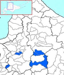
Sorachi is a district divided between Sorachi and Kamikawa Subprefectures, Hokkaido, Japan. As of 2004, the district has an estimated population of 53,011 and an area of 1,497.21 km², giving a population density of 35.41 persons per square kilometer.

The European route E 22 is one of the longest European routes. It has a length of about 5,320 km (3,310 mi). Many of the E-roads have been extended into Asia since the year 2000; the E 22 was extended on 24 June 2002.

The Skylands Region is a region and marketing area of the State of New Jersey located in the Northern and Central part of the state. It is one of six tourism regions established by the New Jersey State Department of Tourism, the others being the Gateway Region, Greater Atlantic City Region, the Southern Shore Region, the Delaware River Region and the Shore Region. The area officially encompasses Hunterdon, Morris, Somerset, Sussex and Warren counties; the northwestern part of the Passaic county fits in with the Skylands Region, but it is part of the Gateway Region and not the Skylands Region. One could also say that the western most part of Bergen is also part of the skylands. The area features uplifted land, rolling hills and mountains characteristic of North Jersey. The region contains 60,000 acres of state parkland, and a diverse geography filled with lakes, rivers and picturesque hills.

Iraklion Air Station was a United States Air Force facility located 16 kilometers (9.9 mi) east of the city of Iraklion near the village of Gournes, in the north central section of the Greek island of Crete.

The Cockermouth River is a 9.5-mile-long (15.3 km) stream located in central New Hampshire in the United States. It is the longest tributary of Newfound Lake, part of the Pemigewasset River and ultimately Merrimack River watersheds. The river takes its name from the "Cockermouth Grant", an early name for a portion of the town of Hebron.

Warsaw Governorate was an administrative unit (governorate) of the Congress Poland.
St Aloysius Higher Secondary School is likely one of the oldest schools in the State of Kerala, India and is located in the District of Kollam. It was founded by the Irish brothers in 1897.

The 1897 Open Championship was the 37th Open Championship, held 19–20 May at Royal Liverpool Golf Club in Hoylake, England. Harold Hilton, an amateur, won the Championship for the second time, a stroke ahead of James Braid.
Borzęcino is a village in the administrative district of Gmina Barwice, within Szczecinek County, West Pomeranian Voivodeship, in north-western Poland.
The Botanischer Schulgarten Burg is a botanical garden for students maintained by the municipal Schulbiologiezentrum Hannover organization. It is located at Vinnhorster Weg 2, Hannover, Lower Saxony, Germany, and open weekdays.

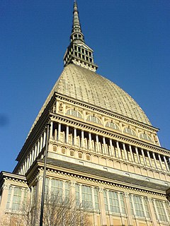
The National Museum of Cinema located in Turin, is an Italian motion picture museum, fitted out inside the Mole Antonelliana tower. It is operated by the Maria Adriana Prolo Foundation, and the core of its collection is the result of the work of the historian and collector Maria Adriana Prolo. It was housed in the Palazzo Chiablese.
Līvi is a village in Biksti Parish and Dobele Municipality in the historical region of Zemgale, and the Zemgale Planning Region in Latvia.

Vadlaheidargong(Vaðlaheiðargöng) is a tunnel in the north of Iceland along Route 1, just east of Akureyri. It passes between Eyjafjordur and Fjoskadalur. It is 7.4 km (4.6 mi) long and replaces a 21 km section of Route 1 including the Vikurskard pass. The tunnel shortens the travel between Akureyri and Husavik by 16 km.
Özbaşı, Posof is a village in the District of Posof, Ardahan Province, Turkey.

The Raduškevičius Palace is a building in Vilnius, Kalvarijų st. 1. Currently it is headquarters of the Lithuanian Architects Union.
Kamiyama-chō (神山町) is a residential district of southwestern Shibuya, Tokyo, Japan. As of 1 December 2015, it has a population of 2,722 people. Its postal code is 150-0047.
Bonifacio Drive is a road running for 1.6 kilometers in a north-south direction between Intramuros and Port Area in Manila, Philippines.

The Novareia sanctuary is devoted to Our Lady of Graces. It is set in the commune of Portula at 750 m height.

The R344 road is a regional road in Ireland, located in west County Galway. It cuts off the loop made by the N59 through Clifden and Letterfrack. .

The Accorsi – Ometto Museum is a private museum based in Turin, northern Italy. It is chronologically the first decorative arts museum in Italy. The museum was originated from a legacy left by Pietro Accorsi and was opened by Giulio Ometto, president for life of the "Fondation Pietro Accorsi" and Director ad interim of the museum.


