Demographics
Historical population| Year | Pop. | ±% p.a. |
|---|
| 2006 | 2,028 | — |
|---|
| 2013 | 2,040 | +0.08% |
|---|
| 2018 | 2,025 | −0.15% |
|---|
| Source: [6] |
The statistical area is called Stanley Point. It had a population of 2,025 at the 2018 New Zealand census, a decrease of 15 people (-0.7%) since the 2013 census, and a decrease of 3 people (-0.1%) since the 2006 census. There were 615 households. There were 1,050 males and 975 females, giving a sex ratio of 1.08 males per female. The median age was 37.7 years, with 387 people (19.1%) aged under 15 years, 492 (24.3%) aged 15 to 29, 891 (44.0%) aged 30 to 64, and 252 (12.4%) aged 65 or older.
Ethnicities were 88.7% European/Pākehā, 7.6% Māori, 2.1% Pacific peoples, 4.0% Asian, and 5.6% other ethnicities (totals add to more than 100% since people could identify with multiple ethnicities).
The proportion of people born overseas was 31.0%, compared with 27.1% nationally.
Although some people objected to giving their religion, 58.4% had no religion, 32.1% were Christian, and 3.6% had other religions.
Of those at least 15 years old, 684 (41.8%) people had a bachelor or higher degree, and 87 (5.3%) people had no formal qualifications. The median income was $47,800. The employment status of those at least 15 was that 945 (57.7%) people were employed full-time, 237 (14.5%) were part-time, and 33 (2.0%) were unemployed. [6]

Devonport is a harbourside suburb of Auckland, New Zealand. It is located on the North Shore, at the southern end of a peninsula that runs southeast from near Lake Pupuke in Takapuna, forming the northern side of the Waitematā Harbour. East of Devonport lies North Head, the northern promontory guarding the mouth of the harbour.

Coromandel, also called Coromandel Town to distinguish it from the wider district, is a town on the Coromandel Harbour, on the western side of the Coromandel Peninsula, which is in the North Island of New Zealand. It is 75 kilometres east of the city of Auckland, although the road between them, which winds around the Firth of Thames and Hauraki Gulf coasts, is 190 km long. The population was 1,890 as of June 2021.

Akaroa is a small town on Banks Peninsula in the Canterbury region of the South Island of New Zealand, situated within a harbour of the same name. The name Akaroa is Kāi Tahu Māori for "Long Harbour", which would be spelled Whangaroa in standard Māori. The area was also named Port Louis-Philippe by French settlers after the reigning French king Louis Philippe I.
Takanini is a southern suburb of Auckland, in northern New Zealand. It is located on the shores of the Pahurehure Inlet, 28 kilometres southeast of the Auckland CBD.

Waitematā Harbour is the main access by sea to Auckland, New Zealand. For this reason it is often referred to as Auckland Harbour, despite the fact that it is one of two harbours adjoining the city. The harbour forms the northern and eastern coasts of the Auckland isthmus and is crossed by the Auckland Harbour Bridge. It is matched on the southern side of the city by the shallower waters of the Manukau Harbour.
Ōrākei is a suburb of Auckland city, in the North Island of New Zealand. It is located on a peninsula five kilometres to the east of the city centre, on the shore of the Waitematā Harbour, which lies to the north, and Hobson Bay and Orakei Basin, two arms of the Waitematā, which lie to the west and south. To the east is the suburb of Mission Bay. The mouth of the Waitematā is to the immediate north of Ōrākei, lying between Bastion Point, in Ōrākei, and North Head, in Devonport on the North Shore.
Tāmaki is a small suburb of East Auckland, 11 kilometres from the Auckland CBD, in the North Island of New Zealand. It is located by the banks of the estuarial Tāmaki River, which is a southern arm of the Hauraki Gulf. The suburb is between the suburbs of Point England to the north and Panmure to the south.

Shelly Park is a South eastern suburb of Auckland, in northern New Zealand. The suburb is in the Howick ward, one of thirteen electoral divisions of the Auckland Council.

Mellons Bay is an Auckland suburb.
Cockle Bay is an eastern suburb of Auckland, New Zealand. The suburb is in the Howick ward, one of the 13 administrative divisions of Auckland city and currently under governance of the Auckland Council. The high school of the area is Howick College, a decile 8 school of the Howick area. The primary schools of the area are Cockle Bay School and Shelly Park Primary School.

Chatswood is a suburb in the city of Auckland, New Zealand, in the middle-eastern side of North Shore. It contains a primary school and many parks. To the south of Chatswood is Kendall's Bay, a small bay of the Waitematā Harbour. The suburb is under the governance of Auckland Council. The Royal New Zealand Navy's Kauri Point Armament Depot is located in Chatswood. Chelsea Sugar Refinery is located in Chatswood.
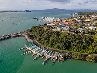
Bayswater is a suburb located on the North Shore of Auckland, New Zealand. It lies on a peninsula which juts into the Waitemata Harbour. The suburb is in the North Shore ward, one of the thirteen administrative divisions of Auckland Council.
Narrow Neck is a suburb located on the North Shore of Auckland, New Zealand. It is under the local governance of the Auckland Council.
Westmere is a residential suburb of Auckland City, New Zealand. Westmere is under the local governance of the Auckland Council. The suburb was originally a working-class area, containing some state houses; mostly private housing originating from housing development in the 1920s. It is known for its Californian style bungalow architecture. It is now a highly sought-after residential location with extensive redevelopment.
Wai o Taiki Bay is a suburb in Auckland, New Zealand. It is under the local governance of Auckland Council.
Rothesay Bay is a small suburb in Auckland's East Coast Bays region. The suburb is roughly the same size as Murrays Bay, the suburb to the immediate south.
Pinehill is a small suburb in the East Coast Bays area of Auckland, New Zealand. Pinehill contains two shopping centres, one along East Coast Road and the other along Greville Road. The suburb has only recently grown because of the housing estates being built in the area for the rapidly growing Albany area. Pinehill is regularly serviced by buses which go to Takapuna and Auckland City. The Auckland Northern Motorway passes to the west of the suburb.
Northcross is a northern suburb of the North Shore in the contiguous Auckland metropolitan area in New Zealand. It is located in the East Coast Bays, a string of small suburbs that make up the northern North Shore. It is located north of the Waitematā Harbour and is currently under local governance of Auckland Council.
Campbells Bay is a suburb of the North Shore located in Auckland, New Zealand.
Windsor Park is a small suburb located on the North Shore of Auckland, which is in New Zealand.

