
America is a town in the Dutch province of Limburg, originated in the late 19th century. It is a part of the municipality of Horst aan de Maas, and lies about 16 km northwest of Venlo. In 2001, the town of America had 991 inhabitants. The built-up area of the town was 0.21 km², and had 397 residences. Including the surrounding countryside, America had 2190 inhabitants as of 2006.

Bystrzyca Stara is a village in the administrative district of Gmina Strzyżewice, within Lublin County, Lublin Voivodeship, in eastern Poland. It lies approximately 20 km (12 mi) south of the regional capital Lublin.
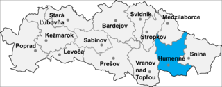
Rovné is a village and municipality in Humenné District in the Prešov Region of north-east Slovakia.

Szadek is a town in Zduńska Wola County, Łódź Voivodeship, Poland, with 1,976 inhabitants (2016).

Șimian is a commune in Bihor County, northwestern Romania with a population of 3,876 people. It is composed of three villages: Șilindru (Érselénd), Șimian and Voivozi (Érkenéz).
Łubice is a village in the administrative district of Gmina Wyszki, within Bielsk County, Podlaskie Voivodeship, in north-eastern Poland.
Mokra Lewa is a village in the administrative district of Gmina Skierniewice, within Skierniewice County, Łódź Voivodeship, in central Poland. It lies approximately 5 kilometres (3 mi) north-west of Skierniewice and 48 km (30 mi) north-east of the regional capital Łódź.
Stara Wróblina is a village in the administrative district of Gmina Stanin, within Łuków County, Lublin Voivodeship, in eastern Poland. It lies approximately 4 kilometres (2 mi) south of Stanin, 15 km (9 mi) south-west of Łuków, and 70 km (43 mi) north of the regional capital Lublin.
Stara Wieś is a village in the administrative district of Gmina Tarczyn, within Piaseczno County, Masovian Voivodeship, in east-central Poland. It lies approximately 7 kilometres (4 mi) south-west of Tarczyn, 23 km (14 mi) south-west of Piaseczno, and 35 km (22 mi) south-west of Warsaw.
Długowizna is a village in the administrative district of Gmina Mszczonów, within Żyrardów County, Masovian Voivodeship, in east-central Poland.
Danowiec is a village in the administrative district of Gmina Mycielin, within Kalisz County, Greater Poland Voivodeship, in west-central Poland.
Głóski is a village in the administrative district of Gmina Nowe Skalmierzyce, within Ostrów Wielkopolski County, Greater Poland Voivodeship, in west-central Poland.
Gostkowo is a village in the administrative district of Gmina Miejska Górka, within Rawicz County, Greater Poland Voivodeship, in west-central Poland.
Mszczyczyn is a village in the administrative district of Gmina Dolsk, within Śrem County, Greater Poland Voivodeship, in west-central Poland. It lies approximately 6 kilometres (4 mi) south of Dolsk, 17 km (11 mi) south of Śrem, and 53 km (33 mi) south of the regional capital Poznań.
Rajewo is a settlement in the administrative district of Gmina Zabór, within Zielona Góra County, Lubusz Voivodeship, in western Poland. It lies approximately 7 kilometres (4 mi) north-west of Zabór and 11 km (7 mi) north-east of Zielona Góra.
Mącznik is a settlement in the administrative district of Gmina Ustka, within Słupsk County, Pomeranian Voivodeship, in northern Poland.
Sobiemierz is a village in the administrative district of Gmina Kołobrzeg, within Kołobrzeg County, West Pomeranian Voivodeship, in north-western Poland.
Mihályfa is a village in Zala County, Hungary.
Broadus Corner is an unincorporated community in Caroline County, in the U.S. state of Virginia.
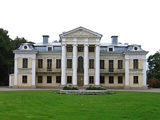
Paežeriai Manor is a former residential manor in Paežeriai village, Vilkaviškis District Municipality, Lithuania. Currently it is occupied by Suvalkija (Sūduva) Cultural Center of Vilkaviškis District.


