
Turweston is a village and civil parish in north-west Buckinghamshire, England. The village is beside the River Great Ouse, which bounds the parish to the north, west and south. Turweston is the most northwesterly parish in Buckinghamshire: the Ouse here forms the county boundary with Northamptonshire to the north and west and Oxfordshire to the south. Across the river, the Northamptonshire market town of Brackley is just west of Turweston, with the town centre about 1 mile (1.6 km) west of the village. The parish has an area of 1,295 acres (524 ha) and had a population of 211 at the 2011 Census.
Bury is a village and civil parish in Cambridgeshire, England. Bury lies approximately 7 miles (11 km) north/north east of Huntingdon and is near to Ramsey and St Ives. Bury is situated within Huntingdonshire which is a non-metropolitan district of Cambridgeshire as well as being a historic county of England.
Great Raveley and Little Raveley are villages near Upwood south of Ramsey. They are located in Huntingdonshire, England, 3½ miles south-west of Ramsey. The population is shown in the civil parish of Upwood and the Raveleys.

Cogges is an area beside the River Windrush in Witney, in the West Oxfordshire district, in Oxfordshire, England, 0.5 miles (800 m) east of the town centre. It had been a separate village and until 1932 it was a separate civil parish.

Hasketon is a village and civil parish in the East Suffolk District of Suffolk, England.

Woodeaton or Wood Eaton is a village and civil parish about 4 miles (6.4 km) northeast of Oxford, England. It also has a special needs school called Woodeaton Manor School.

Warborough is a village and civil parish in South Oxfordshire, about 2.5 miles (4 km) north of Wallingford and about 9 miles (14 km) south of Oxford. The parish also includes the hamlet of Shillingford, south of Warborough beside the River Thames.

Shudy Camps is a village in the south-east corner of Cambridgeshire, England, near the border of Essex and Suffolk, and is part of the Chilford Hundred. In 2001, according to the census, the population was 310, increasing to 338 at the 2011 Census. The area of the village is 951 hectares. It includes the nearby hamlet of Mill Green, a main street and blacksmiths lane. The highest point in the parish is 383' ASL at Mill Green.

Horley is a village and civil parish in the north of Oxfordshire about 3 miles (5 km) north-west of Banbury.

Clanfield is a village and civil parish about three miles (5 km) south of Carterton, Oxfordshire. The parish includes the hamlet of Little Clanfield one mile (1.6 km) west of the village, on Little Clanfield Brook which forms the parish's western boundary. The parish's eastern boundary is Black Bourton Brook and its southern boundary is Radcot Cut, an artificial watercourse on the River Thames floodplain. The 2011 Census recorded the parish's population as 879.

The Parish Church of Saint Giles, Standlake is the Church of England parish church of Standlake, a village about 5 miles (8 km) southeast of Witney in Oxfordshire. Since 1976 St Giles' parish has been a member of the Lower Windrush Benefice along with the parishes of Northmoor, Stanton Harcourt and Yelford.

St John the Baptist's Church is a redundant Anglican church in the village of Strensham, Worcestershire, England. It is recorded in the National Heritage List for England as a designated Grade I listed building, and is under the care of the Churches Conservation Trust. Clifton-Taylor includes the church in his list of 'best' English parish churches.

The Church of St Mary the Virgin, Deane, is an Anglican parish church in Deane, Bolton, Greater Manchester, England. It is a member of Deane deanery in the archdeaconry of Bolton, diocese of Manchester. It is a Grade II* listed building.

Leighton Bromswold is a small village and civil parish in Cambridgeshire, England. Leighton lies approximately 10 miles (16 km) west of Huntingdon. Leighton is situated within Huntingdonshire which is a non-metropolitan district of Cambridgeshire as well as being a historic county of England. The civil parish of which it is part is called Leighton and in 2001 had a population of 224, falling to 210 at the 2011 Census. The parish covers an area of 3,128 acres (1,266 ha).
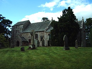
St James' Church is in the village of Great Ormside, Cumbria, England. It is an active Anglican parish church in the deanery of Appleby, the archdeaconry of Carlisle, and the diocese of Carlisle. The parish is united with nine other parishes and thirteen places of worship to form the Heart of Eden benefice. The church is recorded in the National Heritage List for England as a designated Grade I listed building. It stands on top of a circular mound overlooking the River Eden.

Old St Peter and St Paul's Church is a former Anglican church near the village of Albury, Surrey, England in the care of The Churches Conservation Trust. It is recorded in the National Heritage List for England as a designated Grade I listed building. The church stands in Albury Park, to the northwest of Albury Hall, and between the villages of Albury and Shere.

St Mary's Church, Llanfair-yng-Nghornwy is a medieval parish church in the north-west of Anglesey, north Wales. The date of foundation of the church, which is in the village of Llanfair-yng-Nghornwy, is unknown, but the oldest parts date from the 11th or 12th century. It has twice been enlarged: in the 15th century, when the chancel was rebuilt, and in the 16th century, when a chapel was added to the south of the chancel, separated by three arches. The tower at the west end is from the 17th century. A south porch of unknown date has been converted into a vestry, and the church is now entered through the tower.

St Catherine of Siena Church is an Anglican parish church in Cocking, a village in the district of Chichester, one of seven local government districts in the English county of West Sussex.

St Mary Magdalene Church is the Church of England parish church in the village of Ickleton in Cambridgeshire. The church is a Grade I listed building. Its parish is part of a combined benefice with those of St Peter's, Duxford and SS Mary and John, Hinxton.

St Mary's Church is an Anglican parish church in the English village of Welwick in the East Riding of Yorkshire. It is a Grade I listed building.

