The Gloucestershire Wildlife Trust is the Gloucestershire local partner in a conservation network of 46 Wildlife Trusts. The Wildlife Trusts are local charities with the specific aim of protecting the United Kingdom's natural heritage. The Gloucestershire Wildlife Trust is managed by a board of trustees elected from its membership who provide overall direction for the development of the trust and there are advisory committees. The work of the trust is carried out through staff and volunteers.
Allen Banks & Staward Gorge is a 194-acre National Trust property in the English county of Northumberland.

Watersmeet House is a National Trust property located some 1.8 miles (2.9 km) east of Lynmouth, in the English county of Devon. A former fishing lodge, it is today used as an information centre, tea room and shop by the National Trust. Adjoining the house is the Watersmeet SSSI, a Site of Special Scientific Interest.

The River Allen is a river in the English county of Northumberland. The river has its sources in the hills of the Northern Pennines, and is formed by the confluence of the East and West Allen rivers. The Allen is itself, a tributary of the River Tyne. The Allen was formerly very polluted from mining activity upstream, but remediation schemes have been implemented to allow the water quality to improve.

The Clyde Valley Woodlands National Nature Reserve (NNR) comprises six separate woodland sites in the Clyde Valley region of South Lanarkshire, Scotland. These six sites are located along a 12 km section of the River Clyde and its tributaries, and lie close to built-up areas such as Hamilton and Lanark on the southern outskirts of Greater Glasgow. The sites can be easily accessed by about two million people living in the surrounding urban areas, making the reserve unique amongst Scotland's NNRs, most of which tend to be located in more remote areas. The six sites are:
Lower Wye Gorge is a 65-hectare (160-acre) biological and geological Site of Special Scientific Interest in Gloucestershire, notified in 1954 and renotified 1987. The site includes two Gloucestershire Wildlife Trust nature reserves being Ban-y-gor Wood and Lancaut. The Natural England citation states a revision for Lancaut inclusion.

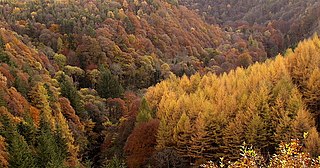
Upper Wye Gorge is a Site of Special Scientific Interest (SSSI), noted for its biological and geological characteristics, around Symonds Yat in the Wye Valley on the Wales–England border. The site is listed in the "Forest of Dean Local Plan Review" as a Key Wildlife Site (KWS).
Shorn Cliff And Caswell Woods is a 69.2-hectare (171-acre) biological Site of Special Scientific Interest in Gloucestershire, notified in 1986. The site is listed in the 'Forest of Dean Local Plan Review' as a Key Wildlife Site (KWS).

The Hudnalls is a 94.4-hectare (233-acre) biological Site of Special Scientific Interest in Gloucestershire, notified in 1972. The site is listed in the 'Forest of Dean Local Plan Review' as a Key Wildlife Site (KWS).

Hack Fall Wood, otherwise known as Hackfall, is a Site of Special Scientific Interest, or SSSI, of 44.8687 hectares, lying north-east of the village of Grewelthorpe, North Yorkshire, England. During the 18th century it was landscaped in the picturesque style by landowner William Aislabie, who created views by engineering streams and pools, planting trees and building follies. J. M. W. Turner and William Sawrey Gilpin painted it, and pictures of it featured on Catherine the Great's 1773 Wedgwood dinner service. Some 19th century writers called it "one of the most beautiful woods in the country."
Kingsbury Wood is a Site of Special Scientific Interest (SSSI) located between Kingsbury and Freasley in Warwickshire, England.
Fishpool Valley is a Site of Special Scientific Interest (SSSI) near Yarpole, Herefordshire, England. This protected area is an area of woodland that is important because of its bird diversity. This protected area is within the Croft Castle estate, owned by the National Trust.
Haugh Wood is a Site of Special Scientific Interest near Woolhope in Herefordshire, England. The protected area is recognised for its diversity of its insects. The Forestry Commission has provided waymarked butterfly trails in this protected area.
Holystone Burn Woods is a Site of Special Scientific Interest (SSSI) within Northumberland National Park in Northumberland, England. It is located near the village of Holystone. The protected area includes part of the valley along which flows the stream called Holystone Burn. Part of the protected area is managed by the Northumberland Wildlife Trust.
Holystone North Wood is a Site of Special Scientific Interest (SSSI) in Northumberland National Park, Northumberland, England. It is located near the village of Holystone. The woodland was historically an oak coppice.
Irthing Gorge is a Site of Special Scientific Interest on the border between the counties of Northumberland and Cumbria, in England. It is located on the south-western boundary of Northumberland National Park where the River Irthing flows near the village of Gilsland. This protected has an exceptional mixture of habitats, including hillside woodland, seepage areas and bare rock. The gorge here cuts through moorland.
Buttermere Fells is a Site of Special Scientific Interest (SSSI) within Lake District National Park in Cumbria, England. The protected area includes many of the hills and mountains between the Buttermere lake valley near the village of Buttermere and the River Derwent valley near the village of Braithwaite. This protected area includes the mountains of Grasmoor, Crag Hill, Causey Pike and Hindscarth. The protected area includes much of the North Western Fells. This protected area contains exceptional examples of montane dwarf shrub heath communities.
Duddon Valley Woodlands is a Site of Special Scientific Interest within the Lake District National Park in Cumbria, England. This protected area comprises eight large patches of woodland along the valley of the River Duddon. The northernmost part of this protected area is near Seathwaite and southern most at Duddon Bridge. This protected area has an exceptional diversity of moss species and also has a population of the common dormouse.
