| Sterkfontein Dam Nature Reserve | |
|---|---|
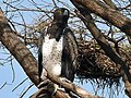
 Grey rhebuck at the nature reserve 16 September 2011 | |
 | |
| Nearest city | Harrismith |
| Coordinates | 28°24′S29°02′E / 28.400°S 29.033°E |
| Area | 18,000 ha (44,000 acres) |
| Website | Sterkfontein/Harrismith - Website |
 Sterkfontein Dam Nature Reserve (South Africa) | |
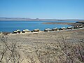
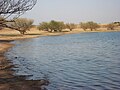
Sterkfontein Dam Nature Reserve is an 18,000 ha reserve situated to the south west of Harrismith, Free State, South Africa. The reserve is close to the Drakensberg Mountain nature reserve. The reserve offers campsites, hiking trails and a large variety of fauna and flora.