
New Britain is the largest island in the Bismarck Archipelago, part of the Islands Region of Papua New Guinea. It is separated from New Guinea by a northwest corner of the Solomon Sea and from New Ireland by St. George's Channel. The main towns of New Britain are Rabaul/Kokopo and Kimbe. The island is roughly the size of Taiwan.

The Bismarck Sea lies in the south-western Pacific Ocean within the Papua New Guinean exclusive economic zone. It is located north-east of the island of New Guinea and south of the Bismarck Archipelago. It has coastlines in districts of the Islands Region, Momase Region, and Papua Region.

The approximately 450 Oceanic languages are a branch of the Austronesian languages. The area occupied by speakers of these languages includes Polynesia, as well as much of Melanesia and Micronesia. Though covering a vast area, Oceanic languages are spoken by only two million people. The largest individual Oceanic languages are Eastern Fijian with over 600,000 speakers, and Samoan with an estimated 400,000 speakers. The Gilbertese (Kiribati), Tongan, Tahitian, Māori and Tolai languages each have over 100,000 speakers. The common ancestor which is reconstructed for this group of languages is called Proto-Oceanic.

Morobe Province is a province on the northern coast of Papua New Guinea. The provincial capital and largest city is Lae. The province covers 33,705 km2, with a population of 674,810, and since the division of Southern Highlands Province in May 2012 it is the most populous province. It includes the Huon Peninsula, the Markham River, and delta, and coastal territories along the Huon Gulf. The province has nine administrative districts. At least 101 languages are spoken, including Kâte and Yabem language. English and Tok Pisin are common languages in the urban areas, and in some areas pidgin forms of German are mixed with the native language.

West New Britain is a province of Papua New Guinea on the islands of New Britain. The provincial capital is Kimbe. The area of the province is 20,387 km2 with a population of 264,264 as of the 2011 census. The province's only land border is with East New Britain. There are seven major tribes, the Nakanai, Bakovi, Kove, Unea, Maleu, Arowe, speaking about 25 languages.
The Meso-Melanesian languages are a linkage of Oceanic languages spoken in the large Melanesian islands of New Ireland and the Solomon Islands east of New Guinea. Bali is one of the most conservative languages.

The Solomon Sea is a sea located within the Pacific Ocean. It lies between Papua New Guinea and Solomon Islands. Many major battles were fought there during World War II.

The Vitu Islands are a volcanic group with an area of 37 sq mi (96 km2) located in the Bismarck Sea off New Britain, in the southwestern Pacific Ocean. They are not technically part of the Bismarck Archipelago. Administratively they are part of Papua New Guinea. Formerly called the French Islands, the group is sometimes known as the Witu Islands.

The Garbuna Group of volcanoes consists of three volcanic peaks, Krummel, Garbuna, and Welcker, atop a shield volcano. They are located at the southern end of the Willaumez Peninsula, just to the west of the town of Kimbe, in West New Britain Province, Papua New Guinea. Garbuna contains a large thermal field, probably Papua New Guinea's largest.
Kimbe is the capital of the province of West New Britain in Papua New Guinea, and the largest settlement on the island. The bustling town of Kimbe is the third largest port in Papua New Guinea and is the fastest growing city in the South Pacific. The town of Kimbe is served by Hoskins Airport.

The Gazelle Peninsula is a large peninsula in northeastern East New Britain, Papua New Guinea located on the island of New Britain within the Bismarck Archipelago, situated in the southwestern Pacific Ocean. The Rabaul caldera is located on the northern tip of the peninsula. Upon the Gazelle Peninsula are the Baining Mountains, of which the highest point is Mount Sinewit at 2,063 m (6,768 ft). The Gazelle Peninsula houses Vulcan Crater and Mount Tavurvur, both of which conducted volcanic activity in the 20th and 21st centuries and have provided extremely fertile soils. The body of the Gazelle Peninsula is about 80 km (50 mi). The southern isthmus upon which the Gazelle Peninsula is connected to the main body of East New Britain is reduced to about 32 km (20 mi).

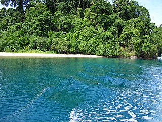
Kimbe Bay is a large bay in West New Britain Province, off the northern coast of New Britain, Papua New Guinea, at 5.1666667°S 150.5°E. Kimbe Bay is an important biodiversity hotspot. 60 percent of the coral species of the entire Indo-Pacific region live here. Kimbe Bay is the home of more than 860 coral reef fish species. Because of a massive die-off of coral worldwide due to pollution, human activities, and global warming, Kimbe Bay has become increasingly important, since it is seen as one of the last holdouts for coral should the degradation continue. Efforts are currently underway to limit the human impact on the bay. Due to its beauty it is also a popular diving site.
Hoskins Airport is an airport in Hoskins in Papua New Guinea. The airport serves Kimbe - the capital of West New Britain province. Mount Pago is 16 km from the airport.
Stettin is the German name of the city of Szczecin, Poland.

New Guinea is the world's second-largest island, with an area of 785,753 km2 (303,381 sq mi). Located in Melanesia in the southwestern Pacific Ocean, the island is separated from Australia by the 150-kilometre wide Torres Strait, though both landmasses lie on the same continental shelf, and were united during episodes of low sea level in the Pleistocene glaciations as the combined landmass of Sahul. Numerous smaller islands are located to the west and east. The island's name was given by Spanish explorer Yñigo Ortiz de Retez during his maritime expedition of 1545 due to the resemblance of the indigenous peoples of the island to those in the African region of Guinea.

The Willaumez Peninsula is located on the north coast of New Britain in the West New Britain Province. It was named after Jean-Baptiste Philibert Willaumez by Antoine Bruni d'Entrecasteaux. The peninsula extends into the Bismarck Sea as an elongated headland and is of volcanic origin. The Dakataua Caldera is located at the northern tip of the Willaumez Peninsula. Kimbe Bay is to the east of the peninsula. On the western side is Riebeck Bay.

Ataliklikun Bay is a bay of East New Britain Province, Papua New Guinea, opening into the Bismarck Sea. It is located in the northern part of New Britain, south-west of Lassul Bay and to the west of Cape Lambert and Rabaul. Urara Island is located in the northern part of the bay. The Raulavat plantation lies in the eastern part of its 25-mile shoreline. The villagers along the shore reportedly speak the Minigir language and the Masava dialect of Tolai. The United States Hydrographic Office said "a reef awash, about 200 yards long east and west, with 15 and 19 fathoms around, on which the steamer Seestem struck in 1909, lies in the south-west part of Ataliklikun Bay."

Urara Island is a small inhabited island in the northern part of Ataliklikun Bay in Papua New Guinea, located just off the mainland of the northern coast of New Britain. There are 3 villages, the largest lying on the southern central part of the coastline. Urara Island lies about 3 miles westward of Cape Liguan, and stands on a reef which extends a short distance only eastward of it and 1.5 miles to the westward. Materbert Island lies about 6 miles west of the island and Watom Island lies to the north-east.

Historical Western Pomerania, also called Cispomerania,Fore Pomerania, Front Pomerania or Hither Pomerania, is the western extremity of the historic region of Pomerania forming the southern coast of the Baltic Sea, located mostly in north-eastern Germany, with a small portion in north-western Poland.

Lolobau Island is an island in the Bismarck Sea, within the West New Britain Province of the Islands Region, in northern Papua New Guinea.

