
Rogaland is a county in Western Norway, bordering the North Sea to the west and the counties of Vestland to the north, Vestfold og Telemark to the east and Agder to the east and southeast. In 2020, it had a population of 479,892. The administrative centre of the county is the city of Stavanger, which is one of the largest cities in Norway.

Stavanger is a city and municipality in Norway. It is the fourth largest city and third largest metropolitan area in Norway and the administrative center of Rogaland county. The municipality is the fourth most populous in Norway. Located on the Stavanger Peninsula in southwest Norway, Stavanger counts its official founding year as 1125, the year the Stavanger Cathedral was completed. Stavanger's core is to a large degree 18th- and 19th-century wooden houses that are protected and considered part of the city's cultural heritage. This has caused the town center and inner city to retain a small-town character with an unusually high ratio of detached houses, and has contributed significantly to spreading the city's population growth to outlying parts of Greater Stavanger.

Sandnes is a city and municipality in Rogaland, Norway. It lies immediately south of Stavanger, the 4th largest city in Norway and together, the Stavanger/Sandnes area is the third-largest urban area in Norway. The urban city of Sandnes lies in the extreme western part of the vast municipality and it makes up about 5% of the total land area of the municipality.

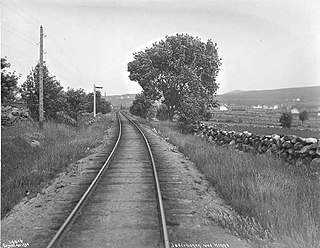
The Jæren Line 74.7-kilometer (46.4 mi) long railway line between Stavanger and Egersund in Jæren, Norway. The name is no longer in official use and the section is regarded as the westernmost part of the Sørlandet Line. Owned by the Norwegian Railway Directorate, the line has double track from Stavanger Station to Sandnes Station, and single track from Sandnes to Egersund Station. The line is electrified at 15 kV 16.7 Hz AC and equipped with centralized traffic control and GSM-R. The line is served by the Jæren Commuter Rail and intercity trains along the Sørlandet Line, both operated by the Vy. CargoNet runs container freight trains on the line, which terminate at Ganddal Freight Terminal.

Hommersåk is a village in Sandnes municipality in Rogaland county, Norway. The village is located in the borough of Riska in the northern part of the municipality. It is situated about 12 kilometres (7.5 mi) northeast of the centre of the city of Sandnes, along the shore of the Riskafjorden, an arm off the main Gandsfjorden. The 2.28-square-kilometre (560-acre) village has a population (2019) of 6,425 and a population density of 2,818 inhabitants per square kilometre (7,300/sq mi).

Eiganes og Våland is a borough of the city of Stavanger which lies in the southwestern part of the large municipality of Stavanger in Rogaland county, Norway. It is located just west of the city centre, north of the lake Mosvatnet, west of the lake Stokkavatnet, and south of the borough of Tasta. The 7.01-square-kilometre (1,730-acre) borough has a population (2019) of 24,070. This gives the borough a population density of 3,400 inhabitants per square kilometre (8,800/sq mi). There are two churches in Eiganes og Våland: Stokka Church and Kampen Church.
Hinna is a borough of the city of Stavanger which lies in the southwestern part of the large municipality of Stavanger in Rogaland county, Norway. The borough includes the southernmost part of the city, bordering the city of Sandnes. The borough of Hillevåg lies to the north, the municipality of Sola lies to the west, and the Gandsfjorden lies to the east. Hillevåg was a part of the old municipality of Hetland until 1965. The borough has residential areas as well as some industrial areas, especially relating to the oil industry. The 15-square-kilometre (3,700-acre) borough has a population (2016) of 22,581. This gives the borough a population density of 1,505 inhabitants per square kilometre (3,900/sq mi).
Stokka is a neighborhood (delområde) in the city of Stavanger which lies in the southwestern part of the large municipality of Stavanger in Rogaland county, Norway. It is located in the borough of Eiganes og Våland. It is located between the European route E39 highway and the lake Stokkavatnet. The neighborhood has a population of 3,599 which is distributed over an area of 3.06 square kilometres. Stokka Church is located in this neighborhood.
Ytre Tasta is a neighborhood (delområde) in the city of Stavanger which lies in the southwestern part of the large municipality of Stavanger in Rogaland county, Norway. It is located in the northern part of the mainland borough of Tasta. The Indre Tasta neighborhood lies to the south, the Gandsfjorden is to the east, and the municipality of Randaberg is to the north and west. The neighborhood has a population of 7,909 which is distributed over an area of 6.01 square kilometres (2.32 sq mi). Vardeneset Church is located in this neighborhood.

Stavanger Airport, Forus is a former airport located at Forus in the intersection of the municipalities of Stavanger, Sola and Sandnes. It was built as a military air base by the Luftwaffe following the German occupation of Norway in April 1940. It was gradually expanded so that it by 1943 consisted of three runways, the longest 1,950 meters (6,400 ft). The airfield was connected by a 3.6-kilometer (2.2 mi) taxiway to Sola Air Station. The airport served as an offensive base during the Battle of Britain, and was afterwards made part of the defensive Festung Norwegen.
Gausel is a neighborhood (delområde) in the city of Stavanger which lies in the southwestern part of the large municipality of Stavanger in Rogaland county, Norway. It is located in the borough of Hinna between the neighborhoods of Jåttå, Godeset, and Forus and the Gandsfjorden.

Forus is an industrial district in the city of Stavanger which lies in the southwestern part of the large municipality of Stavanger in Rogaland county, Norway. It is located in the borough of Hinna, along the Gandsfjorden and it stretches south and west to the municipalities of Sandnes and Sola. The name Forus originates from an old farm located in this area, part of which is currently used for harness racing.
Stokkavatnet is a former lake that was located at Forus in Stavanger, Norway, between the two fjords Hafrsfjord and Gandsfjord. The lake was among the largest at the Northern Jæren district, with an area of about 4 km2. It was surrounded by considerable areas of marsh land, and was known for a rich birdlife. The lake drained to Gandsfjord, and the outlet supplied six mills located near the fjord.
Godeset is a neighborhood (delområde) in the city of Stavanger which lies in the southwestern part of the large municipality of Stavanger in Rogaland county, Norway. It is located in the borough of Hinna, between Gausel and Forus. In Godeset, one can find a number of small industries as well as service industries. Godeset School and Gautesete School are the schools in Godeset. Godeset was an agricultural area until around 1985. The Godeset area stretches from Jåttånuten hill in the north and down to Statoil's headquarters at Forus in the south.

Lura is a borough of the city of Sandnes in the west part of the large municipality of Sandnes in Rogaland county, Norway. The 8-square-kilometre (3.1 sq mi) borough lies in the northwestern part of the city, just north of the city centre of Sandnes and just south of the city of Stavanger. The borough has a population (2016) of 8,605. Lura Church is the main church for the borough. Lura school is one of the primary schools there, with grades from 1–7.

Stavanger Peninsula is a peninsula in Rogaland County, Norway. The peninsula is named for the city of Stavanger, located on its northeastern shore and it includes the most populous parts of the Greater Stavanger urban area. The peninsula extends from a line between the Sandnes harbour at the southern end of the Gandsfjorden straight west to the village of Ølbør in Sola municipality. This line runs just south of Stavanger Airport. The peninsula is delimited by the Gandsfjorden, Boknafjorden, Byfjorden, and the North Sea.

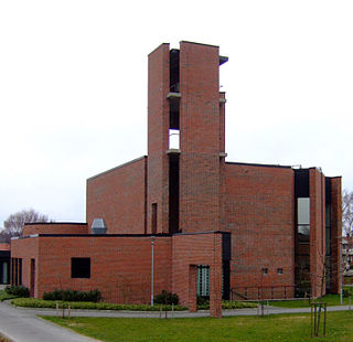
Lura Church is a parish church of the Church of Norway in the large Sandnes municipality in Rogaland county, Norway. It is located in the borough of Lura in the northern part of the city of Sandnes in the extreme western part of the municipality. It is the church for the Lura parish which is part of the Sandnes prosti (deanery) in the Diocese of Stavanger. The red, brick church was built in a fan-shaped design in 1987 using plans drawn up by the architects Ingeborg and Knut Hoem. The church seats about 320 people.
Stokka Church is a parish church of the Church of Norway in Stavanger Municipality in Rogaland county, Norway. It is located in the Stokka neighborhood in the Eiganes og Våland borough in the city of Stavanger. It is the church for the Stokka parish which is part of the Stavanger domprosti (arch-deanery) in the Diocese of Stavanger. The red brick church was built in a fan-shaped design in 1974 using designs by the architectural firm: Byarkitekten Stavanger. The church seats about 500 people.