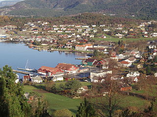
Fitjar is a municipality in Hordaland county, Norway. The municipality is located in the traditional district of Sunnhordland. Fitjar municipality includes the northern part of the island of Stord and the hundreds of surrounding islands, mostly to the northwest of the main island. The administrative centre of the municipality is the village of Fitjar.

The Hardangerfjord is the fourth longest fjord in the world, and the second longest fjord in Norway. It is located in Hordaland county in the Hardanger region. The fjord stretches 179 kilometres (111 mi) from the Atlantic Ocean into the mountainous interior of Norway along the Hardangervidda plateau. The innermost point of the fjord reaches the town of Odda.

The Triangle Link is a fixed link with three branches that connects the islands of Stord and Bømlo to each other and to the mainland at Sveio, Norway. It consists of the underwater Bømlafjord Tunnel from Sveio to the island of Føyno, the Stord Bridge from there to Stord, and a road including the Bømla Bridge and the Spissøy Bridge to Bømlo. The section from Sveio to Stord is part of European Route E39, while the branch to Bømlo is part of County Road 542.
Sunnhordland is a traditional district in the Vestlandet region of Norway. The district consists of the southern coastal regions of Hordaland county. In includes the areas that surround the mouth of the Hardangerfjorden and the surrounding islands. The municipalities of Sveio, Etne, Stord, Bømlo, Fitjar, Kvinnherad, and Tysnes make up the district of Sunnhordaland. The regional centre of this district is the town of Leirvik in Stord.
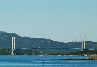
The Stord Bridge is a suspension bridge which crosses Digernessundet between the islands of Stord and Føyno in Stord, Norway. The bridge is 1,077 meters (3,533 ft) long, has a main span of 677 meters (2,221 ft) and a clearance below of 18 meters (59 ft). It carries two lanes of European Route E39 and a combined pedestrian and bicycle pathway. It is part of the Triangle Link, a fixed link which connects Stord to Bømlo, and both to the mainland. In 2010, the bridge had an average 5,021 vehicles per day. The bridge and the link was a toll road from the opening until 30 May 2013.
The Bømla Bridge is a suspension bridge which crosses Spissøysundet between the islands of Nautøy in Stord and Spissøy in Bømlo, Norway. The bridge is 998 meters (3,274 ft) long, has a main span of 577 meters (1,893 ft) and a clearance below of 36 meters (118 ft). It carries two lanes of County Road 542 and a combined pedestrian and bicycle pathway. It is part of the Triangle Link, a fixed link which connects Stord to Bømlo, and both to the mainland at Sveio. Plans for a crossing arose in the 1960s, and was until the 1990s planned as a pontoon bridge further north. The Bømla Bridge entered the plans after the decision to combine the crossing with the Bømlafjord Tunnel. Construction started in 1999; the bridge cost 342 million Norwegian krone (NOK) and was opened for use on 30 April 2001. The bridge is a toll road.
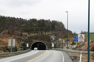
The Bømlafjord Tunnel is a subsea road tunnel under Bømlafjorden which connects the island of Føyno in Stord to the mainland at Dalshovda in Sveio, Norway. The tunnel is 7.82 kilometers (4.86 mi) long and reaches 260.4 m (854 ft) below mean sea level. It carries three lanes of European Road E39 and is part of the Triangle Link, a fixed link which connects Sunnhordland to Haugaland. Plans for the tunnel arose in the 1980s; construction started in 1997 and the tunnel opened on 27 December 2000. The tunnel was built using the drilling and blasting method, with two teams building from each end. The tunnel runs through an area composed mostly of gneiss, phyllite and greenstone. The tunnel is the longest subsea tunnel in Norway and was the second-deepest in the world until 2008. It is still (2013) the deepest point on the E-road network. The tunnel was a toll road from the opening until 30 April 2013. In 2012 the tunnel had an average 4,084 vehicles per day.

Finnås is a former municipality in Hordaland county, Norway. The municipality, which existed from 1838 until 1916 was located in the traditional district of Sunnhordland. Originally, the municipality encompassed all of the island of Bømlo, the small surrounding islands, and the mainland located south of the Bømlafjorden. It was located in the present-day municipalities of Bømlo and Sveio.

Tysnesøya or Tysnesøy is an island in Tysnes municipality in Hordaland county, Norway. The 198-square-kilometre (76 sq mi) island makes up the vast majority of the island municipality of Tysnes. The tallest point on the island is the 753-metre (2,470 ft) tall mountain Tysnessåto.

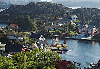
Sagvåg is a village in Stord municipality in Hordaland county, Norway. The village is located on the southwest coast of the island of Stord, about 5 kilometres (3.1 mi) west of the town of Leirvik. The Stord Airport, Sørstokken lies about 2 kilometres (1.2 mi) northwest of Sagvåg. Nysæter Church was built here in 1991 to serve the population of the village. The small mining village of Litlabø lies just northeast of Sagvåg.

Innværfjorden is a small fjord in the municipality of Bømlo in Hordaland county, Norway. It lies on the south of the village of Rubbestadneset on the eastern side of the island of Bømlo. The 3.5-kilometre-long (2.2 mi) fjord flows to the west from the Stokksundet strait.

Føyno is an island in Stord municipality in Hordaland county, Norway. The 1-square-kilometre (0.39 sq mi) island lies southwest of the island of Stord at the southern end of the Stokksundet sound. The Digernessundet strait runs between Stord and this island. Føyno had a central place in the district of Sunnhordland during the Middle Ages, and gave its name to the skipreide of Føyen.
Spissøy or Spyssøya is an island in Bømlo municipality in Hordaland county, Norway. The 1.5-square-kilometre (0.58 sq mi) island lies at the confluence of the Stokksundet strait and the Hardangerfjorden. The island of Bømlo lies to the northwest, the island of Moster lies to the southwest, the island of Otterøya lies to the southeast, and the island of Nautøya lies to the northeast. Spyssøya is connected to the island of Bømlo by the Spissøy Bridge and to the island of Nautøya via the Bømla Bridge. Permanent inhabitants on the small island were few until the bridges were built. Since that time, the island's population has been increasing.
Stokksundet may refer to:
Digernessundet is a strait in the municipality of Stord in Hordaland county, Norway. The 3-kilometre (1.9 mi) long strait runs between the islands of Føyno and Stord, which connects the Stokksundet to the north with the Bømlafjorden to the south. The Stord Bridge crosses the Digernessundet.
Valevåg is a village in Sveio municipality in Hordaland county, Norway. The village is located on the northern end of the Sveio peninsula, along the southern shore of the Hardangerfjorden. Historically, Valevåg was the administrative centre of the old municipality of Valestrand until it was merged into Sveio in 1964. Valen Chapel is in the village of Valevåg, and just outside the village to the south is the much larger Valestrand Church.


