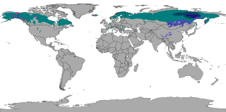
The subarctic climate is a continental climate with long, cold winters, and short, warm to cool summers. It is found on large landmasses, often away from the moderating effects of an ocean, generally at latitudes from 50° to 70°N, poleward of the humid continental climates. Subarctic or boreal climates are the source regions for the cold air that affects temperate latitudes to the south in winter. These climates represent Köppen climate classification Dfc, Dwc, Dsc, Dfd, Dwd and Dsd.

A fellfield or fell field comprises the environment of a slope, usually alpine or tundra, where the dynamics of frost and of wind give rise to characteristic plant forms in scree interstices.

In geology, a hummock is a small knoll or mound above ground. They are typically less than 15 meters (50 ft) in height and tend to appear in groups or fields. Large landslide avalanches that typically occur in volcanic areas are responsible for formation of hummocks. From the initiation of the landslide to the final formation, hummocks can be characterized by their evolution, spatial distribution, and internal structure. As the movement of landslide begins, the extension faulting results in formation of hummocks with smaller ones at the front of the landslide and larger ones in the back. The size of the hummocks is dependent on their position in the initial mass. As this mass spreads, the hummocks further modify to break up or merge to form larger structures. It is difficult to make generalizations about hummocks because of the diversity in their morphology and sedimentology. An extremely irregular surface may be called hummocky.

Frost heaving is an upwards swelling of soil during freezing conditions caused by an increasing presence of ice as it grows towards the surface, upwards from the depth in the soil where freezing temperatures have penetrated into the soil. Ice growth requires a water supply that delivers water to the freezing front via capillary action in certain soils. The weight of overlying soil restrains vertical growth of the ice and can promote the formation of lens-shaped areas of ice within the soil. Yet the force of one or more growing ice lenses is sufficient to lift a layer of soil, as much as 1 foot or more. The soil through which water passes to feed the formation of ice lenses must be sufficiently porous to allow capillary action, yet not so porous as to break capillary continuity. Such soil is referred to as "frost susceptible". The growth of ice lenses continually consumes the rising water at the freezing front. Differential frost heaving can crack road surfaces—contributing to springtime pothole formation—and damage building foundations. Frost heaves may occur in mechanically refrigerated cold-storage buildings and ice rinks.

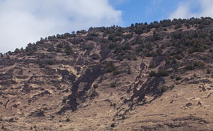
A rockfall or rock-fall is a quantity/sheets of rock that has fallen freely from a cliff face. The term is also used for collapse of rock from roof or walls of mine or quarry workings. "A rockfall is a fragment of rock detached by sliding, toppling, or falling, that falls along a vertical or sub-vertical cliff, proceeds down slope by bouncing and flying along ballistic trajectories or by rolling on talus or debris slopes."
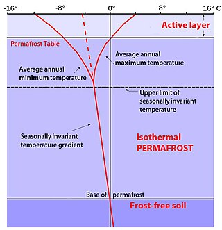
In environments containing permafrost, the active layer is the top layer of soil that thaws during the summer and freezes again during the autumn. In all climates, whether they contain permafrost or not, the temperature in the lower levels of the soil will remain more stable than that at the surface, where the influence of the ambient temperature is greatest. This means that, over many years, the influence of cooling in winter and heating in summer will decrease as depth increases.
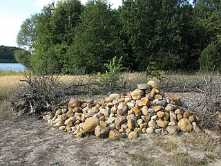
Fieldstone is a naturally occurring type of stone, which lies at or near the surface of the Earth. Fieldstone is a nuisance for farmers seeking to expand their land under cultivation, but at some point it began to be used as a construction material. Strictly speaking, it is stone collected from the surface of fields where it occurs naturally. Collections of fieldstones which have been removed from arable land or pasture to allow for more effective agriculture are called clearance cairns.
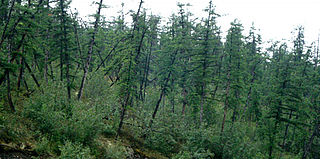
Drunken trees, tilted trees, or a drunken forest, is a stand of trees rotated from their normal vertical alignment.

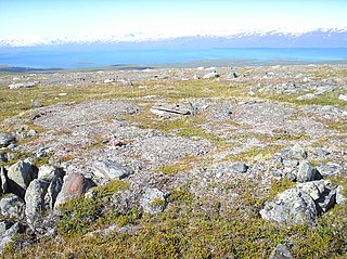
Patterned ground is the distinct and often symmetrical natural pattern of geometric shapes formed by the deformation of ground material in periglacial regions. It is typically found in remote regions of the Arctic, Antarctica, and the Outback in Australia, but is also found anywhere that freezing and thawing of soil alternate; patterned ground has also been observed in the hyper-arid Atacama Desert and on Mars. The geometric shapes and patterns associated with patterned ground are often mistaken as artistic human creations. The mechanism of the formation of patterned ground had long puzzled scientists but the introduction of computer-generated geological models in the past 20 years has allowed scientists to relate it to frost heaving, the expansion that occurs when wet, fine-grained, and porous soils freeze.

Palsas are peat mounds with a permanently frozen peat and mineral soil core. They are a typical phenomenon in the polar and subpolar zone of discontinuous permafrost. One of their characteristics is having steep slopes that rises above the mire surface. This leads to the accumulation of large amounts of snow around them. The summits of the palsas are free of snow even in winter, because the wind carries the snow and deposits on the slopes and elsewhere on the flat mire surface. Palsas can be up to 150 m in diameter and can reach a height of 12 m.

Raised bogs, also called ombrotrophic bogs, are acidic, wet habitats that are poor in mineral salts and are home to flora and fauna that can cope with such extreme conditions. Raised bogs, unlike fens, are exclusively fed by precipitation (ombrotrophy) and from mineral salts introduced from the air. They thus represent a special type of bog, hydrologically, ecologically and in terms of their development history, in which the growth of peat mosses over centuries or millennia plays a decisive role. They also differ in character from blanket bogs which are much thinner and occur in wetter, cloudier climatic zones.
A gilgai is a small, ephemeral lake formed from a depression in the soil surface in expanding clay soils. Additionally, the term "gilgai" is used to refer to the overall micro-relief in such areas, consisting of mounds and depressions, not just the lakes themselves. The name comes from an Australian Aboriginal word meaning small water hole. These pools are commonly a few metres across and less than 30 cm (12 in) deep, however in some instances they may be several metres deep and up to 100 m (330 ft) across. Gilgais are found worldwide wherever cracking clay soils and pronounced wet and dry seasons are present. Gilgais are also called "melonholes, crabholes, hogwallows or puff and shelf formations".
Ice jacking occurs when water permeates a confined space within a structural support or a geological formation, ultimately causing structural fracture when the water freezes and expands. The force from this expansion can damage shorelines, rock faces, and other natural environments. This has the potential to lead to property damage and environmental changes. Ice jacking most commonly refers to shoreline damage caused by lakes freezing, but it has also been applied to geologic engineering and rock erosion. When this occurs within rocks, it is called ice wedging. When this occurs within the soil, it is called frost heaving or ice heaving. It is similar in appearance to, but not to be confused with, ice shove, which is a pile-up of ice on a shoreline.

The Casius quadrangle is one of a series of 30 quadrangle maps of Mars used by the United States Geological Survey (USGS) Astrogeology Research Program. The quadrangle is located in the north-central portion of Mars’ eastern hemisphere and covers 60° to 120° east longitude and 30° to 65° north latitude. The quadrangle uses a Lambert conformal conic projection at a nominal scale of 1:5,000,000 (1:5M). The Casius quadrangle is also referred to as MC-6. Casius quadrangle contains part of Utopia Planitia and a small part of Terra Sabaea. The southern and northern borders of the Casius quadrangle are approximately 3,065 km and 1,500 km wide, respectively. The north to south distance is about 2,050 km. The quadrangle covers an approximate area of 4.9 million square km, or a little over 3% of Mars’ surface area.
A frost boil, also known as mud boils, a stony earth circles, frost scars, or mud circles, are small circular mounds of fresh soil material formed by frost action and cryoturbation. They are found typically found in periglacial or alpine environments where permafrost is present, and may damage roads and other man-made structures. They are typically 1 to 3 metres in diameter.
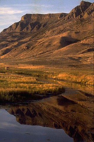
The Warner Valley is a valley in south-central Oregon in the United States. It is a remote valley at the northwestern corner of North America's Basin and Range Province. The valley is home to a chain of lakes and wetlands known as the Warner Lakes. Native Americans were present in the Warner Valley for thousands of years before European explorers arrived in the 19th century. It is the site of Fort Warner, built by the United States Army in 1867. The fort was used as a supply depot and administrative headquarters during a protracted Army campaign against Northern Paiute bands in eastern Oregon and northern California. Today, livestock ranching is the main commercial activity in the valley. The Warner Valley offers a number of recreational opportunities including hunting, fishing, bird watching, and wildlife viewing.
The common surface features of Mars include dark slope streaks, dust devil tracks, sand dunes, Medusae Fossae Formation, fretted terrain, layers, gullies, glaciers, scalloped topography, chaos terrain, possible ancient rivers, pedestal craters, brain terrain, and ring mold craters.

The Catlow Valley is a basin in Harney County, Oregon, United States. It is a remote valley at the northwestern corner of North America's Basin and Range Province. The valley is named after a pioneer rancher, John Catlow. The area was used by Native Americans for thousands of years before European explorers arrived in the 19th century. Today, cattle ranching is the main commercial activity in the valley. The public land in the Catlow Valley is administered by the Bureau of Land Management. This public land offers a number of recreational opportunities including hiking, hunting, fishing, bird watching, and wildlife viewing.

Periglaciation describes geomorphic processes that result from seasonal thawing and freezing, very often in areas of permafrost. The meltwater may refreeze in ice wedges and other structures. "Periglacial" originally suggested an environment located on the margin of past glaciers. However, freeze and thaw cycles influence landscapes also outside areas of past glaciation. Therefore, periglacial environments are anywhere when freezing and thawing modify the landscape in a significant manner.