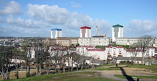
Devonport, formerly named Plymouth Dock or just Dock, is a district of Plymouth in the English county of Devon, although it was, at one time, the more important settlement. It became a county borough in 1889. Devonport was originally one of the "Three Towns" ; these merged in 1914 to form what would become in 1928 the City of Plymouth. It is represented in the Parliament of the United Kingdom as part of the Plymouth Sutton and Devonport constituency. Its elected Member of Parliament (MP) is Luke Pollard, who is a member of the Labour Party. The population of the ward at the 2011 census was 14,788.

The Three Towns is a term used to refer to the neighbouring towns of Plymouth, Devonport and East Stonehouse in the county of Devon, England. They were formally merged in 1914 to become the Borough of Plymouth. In 1928, the Borough was granted City status by Royal Charter.

Union Street in Plymouth, Devon, is a long straight street connecting the city centre to Devonport, the site of Plymouth's naval base and docks. Originally the home of wealthy people, it later became an infamous red-light district and the location of most of the city's night-life.

Devonport High School for Boys is a grammar school and academy, for boys aged 11 to 18, in Plymouth, Devon, England. It has around 1,135 pupils. Its catchment area includes southwest Devon and southeast Cornwall as well as Plymouth. Pupils are accepted on the basis of academic aptitude.
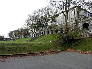
Stoke Military Hospital was an army medical facility in Plymouth, England.

Plymouth, Sutton and Devonport is a constituency created in 2010, represented in the House of Commons of the UK Parliament since 2017 by Luke Pollard a Labour Co-operative party candidate.

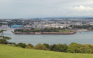
Her Majesty's Naval Base, Devonport, is the largest naval base in Western Europe and is the sole nuclear repair and refuelling facility for the Royal Navy.

Devonport Kings Road railway station was the London and South Western Railway station in Devonport, Devon, England. It opened in 1876 and closed in 1964. For the first 14 years it was a terminal station with trains to London departing eastwards, but from 1890 it became a through station with trains to London departing westwards.
The History of Plymouth in Devon, England, extends back to the Bronze Age, when the first settlement began at Mount Batten a peninsula in Plymouth Sound facing onto the English Channel. It continued as both a fishing and continental tin trading port through the late Iron Age into the Early Medieval period, until the more prosperous Saxon settlement of Sutton, later renamed Plymouth, surpassed it. With its natural harbour and open access to the Atlantic, the town found wealth and a national strategic importance during the establishment of British naval dominance in the colonisation of the New World. In 1620 the Pilgrim Fathers departed from Plymouth to establish the second English colony in America. During the English Civil War the town was besieged between 1642 and 1646 by the Royalists, but after the Restoration a Dockyard was established in the nearby town of Devonport. Throughout the Industrial Revolution Plymouth grew as a major mercantile shipping industry, including imports and passengers from the USA, whilst Devonport grew as a naval base and ship construction town, building battleships for the Royal Navy - which later led to its partial destruction during World War II in a series of air-raids known as the Plymouth Blitz. After the war was over, the city centre was completely rebuilt to a new plan.

Laira Bridge is a disused railway bridge that crosses the River Plym in the city of Plymouth, Devon, England. In 2015, it was refurbished to carry a pedestrian and cycle path.
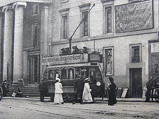
The tramways in Plymouth were originally constructed as four independent networks operated by three different companies to serve the adjacent towns of Plymouth, Stonehouse and Devonport in Devon, England. The merger of the 'Three Towns' into the new borough of Plymouth in 1914 was the catalyst for the three companies to join up under the auspices of the new Plymouth Corporation. The network was closed in 1945, partly as a result of bomb damage during World War II.
The following is a timeline of the history of the city of Plymouth, Devon, England.
Devonport Guildhall, Plymouth, was started in 1821 and completed in 1824. It is a regency building in the Greek Doric style, designed by John Foulston as part of the municipal centre of the town of Devonport.

The fortifications of Plymouth in Devon are extensive due to its natural harbour, its commanding position on the Western Approaches and its role as the United Kingdom's second largest naval base after Portsmouth. The first medieval defences were built to defend Sutton Harbour on the eastern side of Plymouth Sound at the mouth of the River Plym, but by the 18th century, naval activity had begun to shift westward to Devonport at the mouth of the River Tamar. During the Victorian era, advances in military technology led to a huge programme of fortification encompassing the whole of Plymouth Sound together with the overland approaches. Many of these works remained in military use well into the 20th century.