Stoneleigh-Rodgers Forge, Maryland

Last updated
Stoneleigh-Rodgers Forge
Former CDP
USA Maryland location map.svg
Red pog.svg
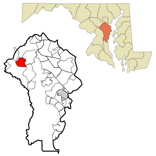
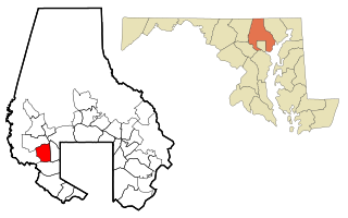
Stoneleigh-Rodgers Forge
Location within the state of Maryland
Coordinates: 39°22′40″N76°37′49″W / 39.37778°N 76.63028°W / 39.37778; -76.63028 Coordinates: 39°22′40″N76°37′49″W / 39.37778°N 76.63028°W / 39.37778; -76.63028
Country United States
State Maryland
County Baltimore
Population (1960)
  Total 15,645
Time zone Eastern (EST) (UTC-5)
  Summer (DST) EDT (UTC-4)
ZIP codes 21212

Stoneleigh-Rodgers Forge was a Census-designated place in Baltimore County during the 1960 United States Census, which consists of the communities of Stoneleigh and Rodgers Forge. [1] The population in 1960 was 15,645. [2] The census area merged with Towson in 1970, when the population of Towson CDP increased from 19,090 to 77,768. [3] The ZIP code serving the area is 21212.

A census-designated place (CDP) is a concentration of population defined by the United States Census Bureau for statistical purposes only. CDPs have been used in each decennial census since 1980 as the counterparts of incorporated places, such as self-governing cities, towns, and villages, for the purposes of gathering and correlating statistical data. CDPs are populated areas that generally include one officially designated but currently unincorporated small community, for which the CDP is named, plus surrounding inhabited countryside of varying dimensions and, occasionally, other, smaller unincorporated communities as well. CDPs include small rural communities, colonias located along the U.S. border with Mexico, and unincorporated resort and retirement communities and their environs.

1960 United States Census

The Eighteenth United States Census, conducted by the Census Bureau, determined the resident population of the United States to be 179,323,175, an increase of 18.5 percent over the 151,325,798 persons enumerated during the 1950 Census. This was the first census in which all states recorded a population of over 200,000.

Stoneleigh Historic District

Stoneleigh Historic District is a national historic district at Towson, Baltimore County, Maryland, United States. It is a cohesive residential neighborhood in Central Baltimore County. The first 110-acre (0.45 km2) section of Stoneleigh was platted in 1922 and later enlarged in 1954 with the central 20 acres (81,000 m2) of land, on which the Italianate-style Stoneleigh Villa once stood. Domestic buildings in Stoneleigh extends from the 1920s to infill housing of the mid 1980s and are suburban examples of the Tudor Revival, Colonial Revival, French Revival, Spanish Mission Revival, Renaissance Revival, and Craftsman styles.

Contents

Geography

The census area of Stoneleigh-Rodgers Forge was located north east of Baltimore and south of the census area of Towson. [4] The land area of the CDP was 2.4 square miles and a population density of 6,519 per sq. mi. [5]

Baltimore Largest city in Maryland

Baltimore is an independent city in the state of Maryland within the United States. Baltimore was established by the Constitution of Maryland as an independent city in 1729. With a population of 611,648 in 2017, Baltimore is the largest such independent city in the United States. As of 2017, the population of the Baltimore metropolitan area was estimated to be just under 2.808 million, making it the 20th largest metropolitan area in the country. Baltimore is located about 40 miles (60 km) northeast of Washington, D.C., making it a principal city in the Washington-Baltimore combined statistical area (CSA), the fourth-largest CSA in the nation, with a calculated 2017 population of 9,764,315.

Education

The student population in the area is served by Baltimore County Public Schools. A few of the schools serving the area include Stoneleigh Elementary, [6] Rodgers Forge Elementary, [7] and Dumbarton Middle School.

Baltimore County Public Schools is the school district in charge of all public schools in Baltimore County, Maryland, United States. It is the 25th largest school system in the US as of 2013. The school system is managed by the Board of Education, headquartered in Towson. The superintendent is Verletta White.

Dumbarton Middle School

Dumbarton Middle School is a school located at 300 Dumbarton Road in the Rodgers Forge neighborhood of Towson, Maryland, just outside Baltimore. It is part of the Baltimore County Public Schools system.

Related Research Articles

Florence-Graham, California Census-designated place in California, United States

Florence-Graham is a census-designated place (CDP) in Los Angeles County, California. The population was 63,387 at the 2010 census, up from 60,197 at the 2000 census. The census area includes separate communities of Florence, Firestone Park, and Graham.

Fort Meade, Maryland Census-designated place in Maryland, United States

Fort Meade is a census-designated place (CDP) in Anne Arundel County, Maryland, United States. The population was 9,327 at the 2010 census. It is the home to the National Security Agency, Central Security Service, United States Cyber Command and the Defense Information Systems Agency, which are located on the U.S. Army post Fort George G. Meade.

Pasadena, Maryland Census-designated place in Maryland, United States

Pasadena is a census-designated place (CDP) in Anne Arundel County, Maryland, United States. The population was 24,287 at the 2010 census.

Carney, Maryland Census-designated place in Maryland, United States

Carney is an unincorporated community and census-designated place in Baltimore County, Maryland, United States. The population was 29,941 at the 2010 census.

Hampton, Maryland Census-designated place in Maryland, United States

Hampton is an unincorporated community and census-designated place (CDP) in Baltimore County, Maryland. The population was 5,052 at the 2010 census. Hampton is often considered a subdivision of the nearby community of Towson and is located just north of Baltimore, about twenty minutes from downtown. Hampton contains residences situated on lots up to several acres in a park-like setting. The community is anchored by its principal landmark, the Hampton National Historic Site. The Towson United Methodist Church is located in Hampton, flanked on the south by I-695 and Goucher College.

Milford Mill, Maryland Census-designated place in Maryland, United States

Milford Mill is an unincorporated community and census-designated place in Baltimore County, Maryland, United States. The population was 29,042 at the 2010 census.

Parkville, Maryland Census-designated place in Maryland, United States

Parkville is an unincorporated community and census-designated place in Baltimore County, Maryland, United States. As of the 2010 census, the population was 30,734.

Perry Hall, Maryland Census-designated place in Maryland, United States

Perry Hall is an unincorporated community and census-designated place in Baltimore County, Maryland, United States. The population was 28,474 at the 2010 census.

Towson, Maryland Census-designated place in Maryland, United States

Towson is an unincorporated community and a census-designated place in Baltimore County, Maryland. The population was 55,197 as of the 2010 census. It is the county seat and the second-most populated unincorporated county seat in the United States.

Camp Springs, Maryland Census-designated place in Maryland

Camp Springs is an unincorporated area and census-designated place (CDP) in Prince George's County, Maryland, United States. The population was 19,096 at the 2010 census. Camp Springs is not an official post office designation; the area is divided between the surrounding mailing addresses of Temple Hills, Fort Washington, Clinton, and Suitland. It includes the unincorporated area of Andrews Manor, Maryland.

East Riverdale, Maryland Census-designated place in Maryland

East Riverdale is an unincorporated area and census-designated place (CDP) in Prince George's County, Maryland, United States. The population was 15,509 at the 2010 census.

Great Falls, Virginia Census-designated place in Virginia, United States

Great Falls is a census-designated place (CDP) in Fairfax County, Virginia, United States. The population as of the 2010 census was 15,427, an increase of 80.5% from the 2000 census.

Woodbridge, Virginia Census-designated place in Virginia, United States

Woodbridge is a census-designated place (CDP) in Prince William County, Virginia, United States, located 20 miles (32 km) south of Washington, D.C. Bounded by the Occoquan and Potomac rivers, Woodbridge Magisterial District had 54,275 residents at the 2010 census. The Woodbridge census-designated place comprises just one portion of the magisterial district and had a population of 4,055 in the 2010 census. The census-designated place consists solely of the section north of Occoquan Road and Dawson Beach Road, and east of Interstate 95.

Glassmanor, Maryland Census-designated place in Maryland

Glassmanor is an unincorporated community and census-designated place in Prince George's County, Maryland, in the United States. As of the 2010 census, it had a population of 17,295. Prior to 2010, the United States Census Bureau had placed Glassmanor and the adjacent community of Oxon Hill in the "Oxon Hill-Glassmanor" census-designated place for statistical purposes.

Lutherville, Maryland Census-designated place in Maryland, United States

Lutherville is a census-designated place (CDP) in Baltimore County, Maryland, United States. As of the 2010 census it had a population of 6,504. Prior to 2010 the area was part of the Lutherville-Timonium CDP. Within its borders lies the Lutherville Historic District.

Monrovia, Maryland Census-designated place in Maryland

Monrovia is an unincorporated community and census-designated place (CDP) in Frederick County, in the U.S. state of Maryland. As of the 2010 census it had a population of 416. The ZIP code for the area is 21770.

Rodgers Forge, Maryland human settlement in United States of America

Rodgers Forge is a national historic district southwest of the unincorporated Towson area and county seat of Baltimore County, Maryland, just north of the Baltimore City/County line. It is mostly a residential area, with rowhouses, apartments, single-family dwellings, and a new complex of luxury garaged townhomes. The area also has a small amount of commercial development. It is just south of Towson University. 21212 is the postal code for Rodgers Forge.

References

  1. 1960 census of population. Retrieved 2013-08-29
  2. 1960 census of population. Retrieved 2010-08-06
  3. 1970 U.S. census: Maryland. Retrieved 2013-08-29
  4. 1960 census of population. Retrieved 2010-08-06
  5. 1960 census of population. Retrieved 2013-08-29
  6. Stoneleigh Elementary. Retrieved 2013-08-29.
  7. Rodgers Forge Elementary. Retrieved 2013-08-29.