Stonyville Township

Last updated

Stonyville Township
Stonyville (1994).jpg
Stonyville, 1994
LocationMareeba Mining District, Palmer, Shire of Cook, Queensland, Australia
Coordinates 16°15′14″S144°21′01″E / 16.2539°S 144.3504°E / -16.2539; 144.3504 Coordinates: 16°15′14″S144°21′01″E / 16.2539°S 144.3504°E / -16.2539; 144.3504
Design period1870s - 1890s (late 19th century)
Built1870s - c.1900
Official name: Stonyville Township, Water Race and Cemetery, Stony Creek Township
Typestate heritage (archaeological)
Designated21 October 1992
Reference no.600433
Significant period1870s-c.1900 (historical)
Significant componentsother - mining/mineral processing: component, cemetery, trees/plantings, water race
Australia Queensland location map.svg
Red pog.svg
Location of Stonyville Township in Queensland
Australia location map.svg
Red pog.svg
Stonyville Township (Australia)

Stonyville Township, Water Race and Cemetery is a heritage-listed mining camp at Mareeba Mining District, Palmer, Shire of Cook, Queensland, Australia. It was built from the 1870s to c.1900. It is also known as Stony Creek Township, Stonyville Water Race, and Stonyville Cemetery. It was added to the Queensland Heritage Register on 21 October 1992. [1]

Palmer, Queensland Suburb of Shire of Cook, Queensland, Australia

Palmer is a locality in the Shire of Cook, Queensland, Australia.

Shire of Cook Local government area in Queensland, Australia

The Shire of Cook is a local government area in Far North Queensland, Australia. The Shire covers most of the eastern and central parts of Cape York Peninsula, the most northerly section of the Australian mainland.

Queensland North-east state of Australia

Queensland is the second-largest and third-most populous state in the Commonwealth of Australia. Situated in the north-east of the country, it is bordered by the Northern Territory, South Australia and New South Wales to the west, south-west and south respectively. To the east, Queensland is bordered by the Coral Sea and Pacific Ocean. To its north is the Torres Strait, with Papua New Guinea located less than 200 km across it from the mainland. The state is the world's sixth-largest sub-national entity, with an area of 1,852,642 square kilometres (715,309 sq mi).

Contents

History

Stony Creek is one of a number of tributaries of Sandy Creek, in the Limestone district south of the Palmer River, that were subjected to a major rush and intensive alluvial mining by Chinese prospectors following James Venture Mulligan's discovery of gold in Sandy Creek in 1874. The alluvial gravels yielded fine gold for several years. [1]

Palmer River river in Queensland, Australia

The Palmer River is a river located in Far North Queensland, Australia. The area surrounding the river was the site of a gold rush in the late 19th century which started in 1873.

James Venture Mulligan Australian explorer

James Venture Mulligan was an Ireland-born Australian prospector and explorer.

It is not recorded when prospecting first commenced in Stony Creek but presumably in the gold rush of 1874. A township developed on the southern side of a wide bend in the creek and in 1882 Len Yue had the hotel, John McLean and Sam Marris had butcher shops, and there were several Chinese stores. By September 1896 when the Government Geologist, Robert Logan Jack, passed through "Stony Creek Township" on his way from Groganville to the Palmer, he noted: [1]

Robert Logan Jack was Queensland government geologist for twenty years. There is a minor waterway on Cape York; Logan Jack Creek, whose outflow is located some 7 kilometres from Ussher Point, which is named after him.

Groganville, Queensland Town in Queensland, Australia

Groganville is a locality in northern Queensland, Australia. It is within the local government area of Shire of Mareeba. It was formerly a mining town and now has a very low population.

"... there are now only four inhabited houses in the street, and a few huts around, all occupied by Chinese. The chief feature of Stony Creek is a huge outcrop of micaceous quartzite-schist....There is a remarkable water-race on the right bank of the creek, which must have cost, inparts at least £500 per mile. The quartzite-schist crosses the creek again and again".

The water race is evidence of Chinese alluvial mining in the area and of the construction skills that had been developed. Prior to the arrival of the Chinese on Stony Creek in large numbers, the European prospectors are reported to have obtained "fantastic amounts" of alluvial gold. Later, the Chinese were reported to be "particularly strong" on Stony Creek. Hence their continuing presence at the time of Jack's visit in 1896 and their cemetery. It is presumed the area was abandoned in the first decade of this century. [1]

Description

Stonyville Water Race, 1994 Stonyville Water Race (1994).jpg
Stonyville Water Race, 1994

The township and cemetery occupy a cleared flat on a horseshoe bend of Stony Creek. A haulage road has recently been driven through the centre of the township to a large area of surface workings that scour the hillside to the north-west of the creek. Evidence of structures in Stony Creek township is now largely archaeological and includes stone surfaces, rock-lined borders and stone cooking places in scattered and disturbed condition. There are two small groups of mango trees. [1]

The cemetery is situated immediately adjacent to the township on the north-west. Cemetery boundaries have recently been assumed with the erection of four corner posts. The area was covered with long grass at the time of survey and only two disturbed arrangements of stones, which may form the perimeter of the cemetery, were evident. The cemetery is reported to contain the foot stones of 15 graves. Two grave markers are reported to have been removed for "safe-keeping" by the Palmer River Historic Preservation Society. [1]

The water race extends for about 1,000 metres (3,300 ft) along the northern and eastern banks of Stony Creek. For most of its length the race consists of a 1 to 2 metres (3 ft 3 in to 6 ft 7 in) wide channel partially cut into bed-rock and raised on a rubble and earth aqueduct up to 6 metres (20 ft) above the creekbed. Several short sections contain packed stone retaining walls 1 to 2.4 metres (3 ft 3 in to 7 ft 10 in) in height. The race is cut through bed rock for about 20 metres (66 ft) through a gorge. The race terminates at an area of past alluvial workings adjacent to Stonyville township. [1]

Heritage listing

Stonyville Township, Water Race and Cemetery was listed on the Queensland Heritage Register on 21 October 1992 having satisfied the following criteria. [1]

The place is important in demonstrating the evolution or pattern of Queensland's history.

The place is significant in Queensland's history for illustrating the pattern of Chinese settlement and alluvial mining operations in a rugged and remote area of North Queensland. [1]

The place demonstrates rare, uncommon or endangered aspects of Queensland's cultural heritage.

The archaeologically intact combination of water race, stone dams, creek alluvial workings, township site and cemetery is unique and the best surviving example of this type of place in Queensland. [1]

The place has potential to yield information that will contribute to an understanding of Queensland's history.

The archaeologically intact combination of water race, stone dams, creek alluvial workings, township site and cemetery is unique and the best surviving example of this type of place in Queensland. [1]

The place is important in demonstrating the principal characteristics of a particular class of cultural places.

The archaeologically intact combination of water race, stone dams, creek alluvial workings, township site and cemetery is unique and the best surviving example of this type of place in Queensland. [1]

The place is important because of its aesthetic significance.

The place exhibits strong visual qualities. [1]

Related Research Articles

Maytown, Queensland ghost town in Queensland, Australia

Maytown was the main township on the Palmer River goldfields in Far North Queensland, Australia. It is now a ghost town within locality of Palmer in the Shire of Cook, having been active from c. 1874 to the 1920s. It was added to the Queensland Heritage Register on 1 June 2004.

Adelong, New South Wales City in New South Wales, Australia

Adelong is a small town in the Riverina region of New South Wales, Australia, situated on the banks of the Adelong Creek. Adelong sits on the Snowy Mountains Highway and is a part of the Snowy Valleys Council. At the 2016 census, Adelong had an urban population of 943.

Paluma, Queensland Town in Queensland, Australia

Paluma is a town in the City of Townsville and a locality in the City of Townsville and the Charters Towers Region in Queensland, Australia. It is a township of around 28 permanent residents in the Mount Spec Ranges and is the southernmost point of Townsville's heritage-listed Wet Tropics.

Adolphus William Copper Smelter

Adolphus William Copper Smelter is a heritage-listed former copper smelter and associated mining camp at Westwood and Oakey Creek in Rockhampton Region, Queensland, Australia. It was built in 1874. It was added to the Queensland Heritage Register on 13 May 2011.

Wenlock Goldfield

Wenlock Goldfield is a heritage-listed mine in Archer River, Shire of Cook, Queensland, Australia. It was built from 1892 to 1950s. It is also known as Batavia Goldfield and Lower Camp (Wenlock). It was added to the Queensland Heritage Register on 3 March 2006.

Ebagoola Township and Battery

Ebagoola Township and Battery is a heritage-listed mining camp at Yarraden, Shire of Cook, Queensland, Australia. It was built from 1900 to 1913. It is also known as Ada Stewart Battery and Ebagoolah Township. It was added to the Queensland Heritage Register on 15 May 2006.

Nuggety Gully Water Race and Chinese Camp

Nuggety Gully Water Race and Chinese Camp is a heritage-listed mining camp at Mareeba Mining District, Lakeland, Shire of Cook, Queensland, Australia. It was built from c. 1878 to c. 1886. It is also known as Greasy Bill Creek water race, Prospect Creek Stone Walls, and Star of Normanby Mine. It was added to the Queensland Heritage Register on 21 October 1992.

Alexandra Mine and Battery

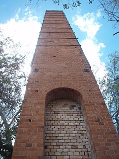
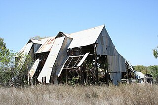
Alexandra Mine and Battery is a heritage-listed mine at Palmerville Station, Maytown, Shire of Cook, Queensland, Australia. It was built from c. 1878 to 1898. It is also known as Alexandra PC.It was added to the Queensland Heritage Register on 21 October 1992.

Wild Irish Girl Mine and Battery

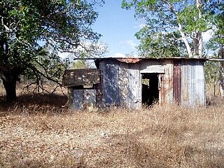
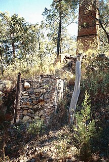
Wild Irish Girl Mine and Battery is a heritage-listed mine at Conglomerate Range, Maytown, Shire of Cook, Queensland, Australia. It was built from c. 1894 to 1980s. It is also known as Emily Battery. It was added to the Queensland Heritage Register on 21 October 1992.

Coolgarra Battery

Coolgarra Battery is a heritage-listed stamper battery at Coolgarra Station, Silver Valley, Tablelands Region, Queensland, Australia. It was built from 1896 to 1901. It is also known as Coolgarra Old Furnace. It was added to the Queensland Heritage Register on 25 August 2000.

Anglo Saxon Mine

Anglo Saxon Mine is a heritage-listed mining camp at Groganville, Shire of Mareeba, Queensland, Australia. It was built from 1886 to 1897. It is also known as Groganville Township and Limestone Cemetery. It was added to the Queensland Heritage Register on 3 October 2003.

Fischerton Water Race

Fischerton Water Race is a heritage-listed aqueduct at Tate-Almaden Road, Crystalbrook, Shire of Mareeba, Queensland, Australia. It was designed by George Bell and built in 1894. It was added to the Queensland Heritage Register on 21 November 2003.

Kingsborough Battery

Kingsborough Battery is a heritage-listed mining building off the former East Street, Kingsborough, Thornborough, Shire of Mareeba, Queensland, Australia. It was built from c. 1896 to 1990s. It was added to the Queensland Heritage Register on 21 October 1992.

Aspasia Mine and Battery

Aspasia Mine and Battery is a heritage-listed mine and stamper battery at Gulf Developmental Road, Georgetown, Shire of Etheridge, Queensland, Australia. It was built from 1916 to 1952. It is also known as Mount Turner Battery. It was added to the Queensland Heritage Register on 13 April 2006.

Kidston State Battery & Township

Kidston State Battery is a heritage-listed stamper battery at Kidston in Einasleigh, Shire of Etheridge, Queensland, Australia. It was built from 1907 to 1950. It is also known as Kidston Township. It was added to the Queensland Heritage Register on 21 October 1992.

Homeward Bound Battery and Dam dam in Australia

Homeward Bound Battery and Dam is a heritage-listed stamping mill and reservoir at Croydon, Shire of Croydon, Queensland, Australia. It was built in 1888 by Mr Schumacher. It was added to the Queensland Heritage Register on 21 October 1992.

Golden Gate Mining and Town Complex

Golden Gate Mining and Town Complex is a heritage-listed mining camp at Normanton Road, Croydon, Shire of Croydon, Queensland, Australia. It commenced in 1886. It is also known as Golden Gate Township, Croydon Consols Pump Shaft, Golden Gate No.10 North Mine, Golden Gate Cemetery, Croydon Consols Battery and Cyanide Plant, and Golden Gate Mine. It was added to the Queensland Heritage Register on 14 August 2009.

Adelong Falls Gold Workings

The Adelong Falls Gold Workings is an heritage-listed former gold processing site and now picnic reserve at Adelong, Snowy Valleys Council, New South Wales, Australia. It was designed and built in 1860 by David Wilson and William Ritchie. It is also known as Adelong Falls Gold Workings/Reserve. The property is owned by the Snowy Valleys Council. It was added to the New South Wales State Heritage Register on 2 April 1999.

Gold Mining Water Race, Windeyer

Gold Mining Water Race is a heritage-listed piece of mining infrastructure at Old Hargraves Road, Windeyer, Mid-Western Regional Council, New South Wales, Australia. It was built from 1855 to 1865 by Chinese miners, probably from Southern China. It was added to the New South Wales State Heritage Register on 22 December 2000.

References

  1. 1 2 3 4 5 6 7 8 9 10 11 12 13 "Stonyville Township, Water Race and Cemetery (entry 600433)". Queensland Heritage Register . Queensland Heritage Council. Retrieved 1 August 2014.

Attribution

CC-BY-icon-80x15.png This Wikipedia article was originally based on "The Queensland heritage register" published by the State of Queensland under CC-BY 3.0 AU licence (accessed on 7 July 2014, archived on 8 October 2014). The geo-coordinates were originally computed from the "Queensland heritage register boundaries" published by the State of Queensland under CC-BY 3.0 AU licence (accessed on 5 September 2014, archived on 15 October 2014).

Commons-logo.svg Media related to Stonyville Township at Wikimedia Commons