Stourport Ring

Last updated

Stourport Ring
Stourport ring.GIF
Map of the Ring
Specifications
Length74 miles (119 km)
Locks105
StatusCanal ring
Navigation authorityCanal & River Trust

The Stourport Ring is a connected series of canals forming a circuit, or canal ring, around Worcestershire, The Black Country and Birmingham in The Midlands, England. The ring is formed from the River Severn, the Staffordshire and Worcestershire Canal, the Stourbridge Canal, the Dudley Canals, the Birmingham Canal Navigations (Netherton Tunnel Branch Canal and Birmingham New Main Line) and the Worcester and Birmingham Canal.

Contents

The ring is 74 miles and includes 105 locks including 3 electrically operated river locks, 2 pairs of staircase locks and 2 broad locks. The route includes flights of locks at Tardebigge (x30), Stourbridge (x16) and the Black Delph at Brierley Hill (x8). The route also includes two of the longest navigable tunnels on the UK network, these being the Netherton and Wast Hills Tunnels.

The ring has an alternative longer route via Wolverhampton of 83 miles and 122 locks and does not include the Stourbridge or Dudley canals. This route uses the connection between the Staffordshire and Worcestershire Canal, and the BCN Main Line at Aldersley Junction.

The ring is popular for cruising and has a number of narrowboat hire centres on the route including Alvechurch, Viking Afloat (Worcester), Anglo-Welsh (Tardebigge), Brook Line (Dunhampstead) and Black Prince (Stoke Prior).

Whittington Lock on the S&W Canal Whittington lock.jpg
Whittington Lock on the S&W Canal

Popular visitor attractions on or close to the Stourport Ring include Cadbury World, The Black Country Living Museum, the Severn Valley Railway, Kinver Edge, the Birmingham Jewellery Quarter, Brindleyplace plus the Merry Hill, Bullring and Mailbox shopping centres.

Popular overnight mooring places on the ring include Worcester city centre, Stourport Basin, Wolverley, Kinver, Merry Hill, Windmill End, The Black Country Museum (via short detour), Gas Street Basin, Hopwood, Stoke Works and Dunhampstead.
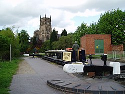
Kidderminster Lock on the S&W Canal Kidderminster Lock.jpg
Kidderminster Lock on the S&W Canal

List of all locks on the ring with their map references

Based on travelling clockwise and starting at Worcester. Excludes the northern extension.

Lock NumberWaterwayLock Name Coordinates OS Grid Ref
1River SevernBevere Lock 52°14′00″N2°14′27″W / 52.2333°N 2.2407°W / 52.2333; -2.2407 (Bevere Lock) SO835593
2Holt Lock SO820634
3Lincomb Lock 52°19′18″N2°15′53″W / 52.3216°N 2.2646°W / 52.3216; -2.2646 (Lincomb Lock) SO821693
4/5Staffordshire and Worcestershire CanalStourport basin lower staircase SO809710
6/7Stourport basin upper staircase SO809710
8Stourport York Street Lock 3 52°20′19″N2°16′43″W / 52.3386°N 2.2787°W / 52.3386; -2.2787 (Stourport York Street Lock 3) SO811712
9Falling Sands Lock 4 52°22′03″N2°15′17″W / 52.3674°N 2.2548°W / 52.3674; -2.2548 (Falling Sands Lock 4) SO827744
10Caldwell Lock 5 52°22′42″N2°15′17″W / 52.3783°N 2.2548°W / 52.3783; -2.2548 (Caldwell Lock 5) SO827756
11Kidderminster Lock 6 SO829768
12Wolverley Court Lock 7 52°24′11″N2°15′09″W / 52.4031°N 2.2524°W / 52.4031; -2.2524 (Wolverley Court Lock 7) SO829784
13Wolverley Lock 8 52°24′37″N2°14′59″W / 52.4102°N 2.2497°W / 52.4102; -2.2497 (Wolverley Lock 8) SO830791
14Debdale Lock 9 SO839801
15Whittington Lock 10 52°26′26″N2°13′02″W / 52.4406°N 2.2171°W / 52.4406; -2.2171 (Whittington Lock 10) SO853825
16Kinver Lock 11 SO848834
17Hyde Lock 12 SO848834
18Stewponey Lock 13 52°27′42″N2°12′21″W / 52.4616°N 2.2059°W / 52.4616; -2.2059 (Stewponey Lock 13) SO850842
19Stourbridge CanalStourton Bottom Lock 52°27′49″N2°12′17″W / 52.4636°N 2.2047°W / 52.4636; -2.2047 (Stourton Bottom Lock) SO861851
20Stourton Lock SO862851
21Stourton Lock SO864852
22Stourton Top Lock 52°27′53″N2°11′56″W / 52.4646°N 2.1990°W / 52.4646; -2.1990 (Stourton Top Lock) SO865852
23Stourbridge Bottom Lock 16 52°28′22″N2°09′51″W / 52.4728°N 2.1643°W / 52.4728; -2.1643 (Stourbridge Bottom Lock 16) SO889861
24Stourbridge Lock 15 SO890863
25Stourbridge Lock 14 SO891863
26Stourbridge Lock 13 SO892864
27Stourbridge Lock 12 SO894865
28Stourbridge Lock 11 SO895865
29Stourbridge Lock 10 SO895865
30Stourbridge Lock 9 SO896865
31Stourbridge Lock 8 SO897866
32Stourbridge Lock 7 SO897867
33Stourbridge Lock 6 SO898867
34Stourbridge Lock 5 SO899868
35Stourbridge Lock 4 SO899868
36Stourbridge Lock 3 SO900869
37Stourbridge Lock 2 SO902871
38Stourbridge Top Lock 1 52°28′58″N2°08′37″W / 52.4829°N 2.1436°W / 52.4829; -2.1436 (Stourbridge Top Lock 1) SO903872
39Dudley Canal Line No. 1Delph Bottom Lock 8 52°28′32″N2°07′23″W / 52.4756°N 2.1230°W / 52.4756; -2.1230 (Delph Bottom Lock 8) SO917863
40Delph Lock 7 SO917864
41Delph Lock 6 SO918864
42Delph Lock 5 SO918865
43Delph Lock 4 SO918865
44Delph Lock 3 SO919866
45Delph Lock 2 SO920866
46Delph Top Lock 1 52°28′44″N2°07′06″W / 52.4790°N 2.1184°W / 52.4790; -2.1184 (Delph Top Lock 1) SO920867
47Blowers Green Lock* 52°29′51″N2°05′52″W / 52.4975°N 2.0979°W / 52.4975; -2.0979 (Blowers Green Lock) SO934888
Dudley Canal Line No. 2(no locks)
Netherton Tunnel Branch Canal(no locks)
Birmingham New Main Line(no locks)
48Worcester and Birmingham CanalTardebigge Top Lock No 58* 52°19′17″N2°00′39″W / 52.3214°N 2.0107°W / 52.3214; -2.0107 (Tardebigge Top Lock No 58) SO993692
49Tardebigge Lock No 57 SO987689
50Tardebigge Lock No 56 SO987688
51Tardebigge Lock No 55 SO986688
52Tardebigge Lock No 54 SO986688
53Tardebigge Lock No 53 SO984686
54Tardebigge Lock No 52 SO984686
55Tardebigge Lock No 51 SO984685
56Tardebigge Lock No 50 SO984685
57Tardebigge Lock No 49 SO982683
58Tardebigge Lock No 48 SO982683
59Tardebigge Lock No 47 SO980683
60Tardebigge Lock No 46 SO979683
61Tardebigge Lock No 45 SO979683
62Tardebigge Lock No 44 SO978682
63Tardebigge Lock No 43 SO976682
64Tardebigge Lock No 42 SO976682
65Tardebigge Lock No 41 SO975682
66Tardebigge Lock No 40 SO974682
67Tardebigge Lock No 39 SO973681
68Tardebigge Lock No 38 SO972680
69Tardebigge Lock No 37 SO971680
70Tardebigge Lock No 36 SO970679
71Tardebigge Lock No 35 SO969679
72Tardebigge Lock No 34 SO968678
73Tardebigge Lock No 33 SO967678
74Tardebigge Lock No 32 SO966678
75Tardebigge Lock No 31 SO965679
76Tardebigge Lock No 30 SO964679
77Tardebigge Bottom Lock No 29 52°18′36″N2°03′15″W / 52.3099°N 2.0542°W / 52.3099; -2.0542 (Tardebigge Bottom Lock No 29) SO962679
78Stoke Top Lock No 28 52°18′28″N2°03′28″W / 52.3078°N 2.0578°W / 52.3078; -2.0578 (Stoke Top Lock No 28) SO961677
79Stoke Lock No 27 SO956672
80Stoke Lock No 26 SO958672
81Stoke Lock No 25 SO956672
82Stoke Lock No 24 SO955671
83Stoke Prior Bottom Lock No 23 52°18′05″N2°04′16″W / 52.3015°N 2.0710°W / 52.3015; -2.0710 (Stoke Prior Bottom Lock No 23) SO952670
84Astwood Top Lock No 22 52°17′17″N2°05′19″W / 52.2880°N 2.0886°W / 52.2880; -2.0886 (Astwood Top Lock No 22) SO940655
85Astwood Lock No 21 SO939654
86Astwood Lock No 20 SO939653
87Astwood Lock No 19 SO937652
88Astwood Lock No 18 SO936650
89Astwood Bottom Lock No 17 52°16′41″N2°05′51″W / 52.2781°N 2.0974°W / 52.2781; -2.0974 (Astwood Bottom Lock No 17) SO934644
90Offerton Top Lock No 16 52°13′14″N2°09′05″W / 52.2205°N 2.1514°W / 52.2205; -2.1514 (Offerton Top Lock No 16) SO897580
91Offerton Lock No 15 SO896580
92Offerton Lock No 14 SO894580
93Offerton Lock No 13 SO893580
94Offerton Lock No 12 SO890578
95Offerton Bottom Lock No 11 52°13′04″N2°09′53″W / 52.2178°N 2.1646°W / 52.2178; -2.1646 (Offerton Bottom Lock No 11) SO888577
96Tolladine Lock No 10 SO877576
97Blackpole Lock No 9 SO869576
98Bilford Top Lock SO856570
99Bilford Bottom Lock SO856569
100Gregory's Mill Top Lock SO850565
101Gregory's Mill Bottom Lock SO853553
102Blockhouse Lock No 4 SO854546
103Sidbury Lock No 3 SO852544
104Diglis Basin Lock No 2 SO849538
105Diglis Basin Lock No 1 52°10′57″N2°13′22″W / 52.1826°N 2.2229°W / 52.1826; -2.2229 (Diglis Basin Lock No 1) SO848538

During spring freshet the Severn can be closed to navigation, making the ring not fully navigable. There is also potential for some sections of the ring being temporarily unnavigable consequent to lack of water during a drought.

See also

Related Research Articles

<span class="mw-page-title-main">Worcestershire</span> County of England

Worcestershire is a ceremonial county in the West Midlands of England. It is bordered by Shropshire, Staffordshire, and the West Midlands county to the north, Warwickshire to the east, Gloucestershire to the south, and Herefordshire to the west. The city of Worcester is the largest settlement and the county town.

<span class="mw-page-title-main">Stratford-upon-Avon Canal</span> United Kingdom legislation

The Stratford-upon-Avon Canal is a canal in the south Midlands of England. The canal, which was built between 1793 and 1816, runs for 25.5 miles (41.0 km) in total, and consists of two sections. The dividing line is at Kingswood Junction, which gives access to the Grand Union Canal. Following acquisition by a railway company in 1856, it gradually declined, the southern section being un-navigable by 1945, and the northern section little better.

<span class="mw-page-title-main">Staffordshire and Worcestershire Canal</span> Canal in the West Midlands, England

The Staffordshire and Worcestershire Canal is a navigable narrow canal in Staffordshire and Worcestershire in the English Midlands. It is 46 miles (74 km) long, linking the River Severn at Stourport in Worcestershire with the Trent and Mersey Canal at Haywood Junction by Great Haywood.

<span class="mw-page-title-main">Birmingham Canal Navigations</span> United Kingdom legislation

Birmingham Canal Navigations (BCN) is a network of canals connecting Birmingham, Wolverhampton, and the eastern part of the Black Country. The BCN is connected to the rest of the English canal system at several junctions. It was owned and operated by the Birmingham Canal Navigation Company from 1767 to 1948.

<span class="mw-page-title-main">River Stour, Worcestershire</span> River in the West Midlands, England

The Stour(, rhymes with "flour") is a river flowing through the counties of Worcestershire, the West Midlands and Staffordshire in the West Midlands region of England. The Stour is a major tributary of the River Severn, and is about 25 miles (40 km) in length. It has played a considerable part in the economic history of the region.

<span class="mw-page-title-main">Stourbridge</span> Town in the West Midlands, England

Stourbridge is a market town in the Metropolitan Borough of Dudley in the West Midlands, England. Situated on the River Stour, the town lies around 10 miles west of Birmingham. Historically in Worcestershire, it was the centre of British glass making during the Industrial Revolution. The 2011 UK census recorded the town's population as 63,298.

<span class="mw-page-title-main">Shropshire Union Canal</span> Canal in North West England

The Shropshire Union Canal, nicknamed the "Shroppie", is a navigable canal in England. The Llangollen and Montgomery canals are the modern names of branches of the Shropshire Union (SU) system and lie partially in Wales.

<span class="mw-page-title-main">Worcester and Birmingham Canal</span> Canal in the United Kingdom

The Worcester and Birmingham Canal is a canal linking Birmingham and Worcester in England. It starts in Worcester, as an 'offshoot' of the River Severn and ends in Gas Street Basin in Birmingham. It is 29 miles (47 km) long. There are 58 locks in total on the canal, including the 30 Tardebigge Locks, one of the longest lock flights in Europe. The canal climbs 428 feet (130 m) from Worcester to Birmingham.

<span class="mw-page-title-main">Dudley Tunnel</span> Canal tunnel on the Dudley Canal

Dudley Tunnel is a canal tunnel on the Dudley Canal Line No 1, England. At about 3,172 yards (2,900.5 m) long, it is now the second longest canal tunnel on the UK canal network today.. However, since the Dudley Tunnel is not continuous this status is sometimes questioned:.

<span class="mw-page-title-main">Leominster Canal</span> Canal in England, now defunct

The Leominster Canal was an English canal which ran for just over 18 miles from Mamble to Leominster through 16 locks and a number of tunnels, some of which suffered engineering problems even before the canal opened. Originally, the canal was part of a much more ambitious plan to run 46 miles from Stourport to Kington.

<span class="mw-page-title-main">A449 road</span> Major road in England and Wales

The A449 is a major road in the United Kingdom. It runs north from junction 24 of the A48 road at Newport in South Wales to Stafford in Staffordshire.

A canal ring is the name given to a series of canals that make a complete loop.

<span class="mw-page-title-main">Netherton Tunnel Branch Canal</span> Canal tunnel in the West Midlands, England

Netherton Tunnel Branch Canal, in the West Midlands county, England, is part of the Birmingham Canal Navigations, (BCN). It was constructed at a 453–foot elevation, the Wednesbury or Birmingham level; it has no locks. The total length of the branch canal is 2.4 miles (3.9 km) and the canal tunnel is 9,081 feet (2,768 m) long.

<span class="mw-page-title-main">Stourbridge Canal</span> Canal in England

The Stourbridge Canal is a canal in the West Midlands of England. It links the Staffordshire and Worcestershire Canal with the Dudley Canal, and hence, via the Birmingham Canal Navigations, to Birmingham and the Black Country.

<span class="mw-page-title-main">Dudley Canal</span> Canal in the West Midlands, England

The Dudley Canal is a canal passing through Dudley in the West Midlands of England. The canal is part of the English and Welsh network of connected navigable inland waterways and forms part of the popular Stourport Ring narrowboat cruising route.

Stourton is a hamlet in Staffordshire, England a few miles to the northwest of Stourbridge. There is a fair amount of dispute over the pronunciation, being pronounced 'stower-ton', 'stir-ton' or 'store-ton' by different people from the area. The nearest sizeable villages are Wollaston and Kinver, the nearest hamlets are Prestwood and Dunsley. It lies on the River Stour. The Staffordshire and Worcestershire Canal and Stourbridge Canal meet at Stourton Junction, which places Stourton on the Stourport Ring, a navigable waterway popular with narrowboat holidaymakers.

The BCN Main Line, or Birmingham Canal Navigations Main Line is the evolving route of the Birmingham Canal between Birmingham and Wolverhampton in England.

<span class="mw-page-title-main">Water levels of the Birmingham Canal Navigations</span>

The Birmingham Canal Navigations (BCN), a network of narrow canals in the industrial midlands of England, is built on various water levels. The three longest are the Wolverhampton, Birmingham, and Walsall levels. Locks allow boats to move from one level to another.

<span class="mw-page-title-main">Avon Ring</span> Canal ring in England

The Avon Ring is a canal ring which is located to the south west of Birmingham in England, and connects the major towns of Stratford-upon-Avon, Evesham, Tewkesbury, Worcester and the southern outskirts of Birmingham. It consists of stretches of four waterways, and is heavily locked, with a total of 129 locks on its route of 109 miles (175 km).

<span class="mw-page-title-main">Pensnett Canal</span> Canal in West Midlands, England

The Pensnett Canal, also called Lord Ward's Canal was a private 1.25 miles (2 km) long canal near Brierley Hill, West Midlands, England, which opened in 1840 and served the industrial enterprises of Lord Dudley's Estate. The engineer was Mathew Frost. Since its closure to navigation in 1950, much of it has been lost by overbuilding, but a small section at its junction with the Dudley Canal was restored in 1995, and the section through Brierley Hill remains in water, although it is polluted and not navigable.

References