Avon Ring

Last updated

Avon Ring
Kings Norton Junction.jpg
Specifications
Length109 miles (175 km)
Locks129
Status Canal ring
Navigation authority Canal & River Trust & Avon Navigation Trust

The Avon Ring is a canal ring which is located to the south west of Birmingham in England, and connects the major towns of Stratford-upon-Avon, Evesham, Tewkesbury, Worcester and the southern outskirts of Birmingham. It consists of stretches of four waterways, and is heavily locked, with a total of 129 locks on its route of 109 miles (175 km).

Contents

The route

Avon Ring
BSicon uCONTg.svg
Worcester and Birmingham Canal
BSicon uFABZgl+l.svg
BSicon uSTRq.svg
BSicon uSTR+r.svg
Kings Norton Junction
BSicon uSTR.svg
BSicon uTUNNEL1.svg
Brandwood Tunnel (320m)
BSicon uTUNNEL1.svg
BSicon uSTR.svg
Wast Hills Tunnel (2495m)
BSicon uSTR.svg
BSicon uLOCKSu.svg
19 locks
BSicon uSTR.svg
BSicon uFABZgl+l.svg
BSicon uCONTfq.svg
Kingswood Junction
BSicon uTUNNEL1.svg
BSicon uSTR.svg
Shortwood Tunnel (560m)
BSicon uTUNNEL1.svg
BSicon uSTR.svg
Tardebigge Tunnel (530m)
BSicon uLOCKSu.svg
BSicon uSTR.svg
Tardebigge flight (30 locks)
BSicon uSTR.svg
BSicon uLOCKSu.svg
18 locks
BSicon uKMW.svg
BSicon uSTR.svg
Worcester and Birmingham Canal
BSicon uLOCKSu.svg
BSicon uSTR.svg
28 locks
BSicon uSTR.svg
BSicon uKMW.svg
Stratford-on-Avon Canal
BSicon uCONTgq.svg
BSicon uSTR+r.svg
BSicon uSTR+FEATURE@l.svg
BSicon uSTR.svg
Worcester
BSicon uFABZgl+l.svg
BSicon uSTRr.svg
BSicon uSTR.svg
BSicon uFGATEu.svg
BSicon uSTR.svg
Diglis lock
BSicon uKMW.svg
BSicon uSTR.svg
River Severn
BSicon uSTR.svg
BSicon uLOCKSu.svg
17 locks
BSicon uSTR.svg
BSicon uSTR+FEATURE@l.svg
Stratford upon Avon
BSicon uSTR.svg
BSicon uSTR+l.svg
BSicon uFABZqlr.svg
BSicon uCONTfq.svg
River Avon
BSicon uSTR.svg
BSicon uLOCKSu.svg
10 locks
BSicon uSTR.svg
BSicon uSTR+FEATURE@l.svg
Evesham
BSicon uSTR.svg
BSicon uKMW.svg
River Avon
BSicon uSTR.svg
BSicon uLOCKSu.svg
6 locks
BSicon uSTR.svg
BSicon uSTR+FEATURE@l.svg
Tewkesbury
BSicon uFABZgl+l.svg
BSicon uFGATEr.svg
BSicon uSTRr.svg
Avon Lock
BSicon uCONTf.svg
River Severn

The concept of a canal ring is a recent one, having been coined in 1965 to describe routes which could be used by people boating for leisure, that did not require holiday makers to return to their start location by the same route as they had used to reach their destination. [1] The constituent waterways of the Avon Ring, which can take about two weeks to navigate [2] are:

Starting from Stratford-upon-Avon, and travelling in a clockwise direction, the Avon Ring follows the downstream course of the River Avon through Evesham to arrive at Tewkesbury, where the river joins the River Severn. There are 17 locks on this 42.2-mile (67.9 km) section, ten before Evesham and seven afterwards. The River Avon is a navigation, and so each lock is accompanied by a weir, to maintain the flow of the river. [3]

From Tewkesbury, the ring follows the upstream course of the River Severn for 16 miles (26 km) to Worcester. [4] This is the longest level section, as the only lock is located at Diglis, just before the junction with the Worcester and Birmingham Canal. [5]

From the junction with the River Severn, there are two locks to reach Diglis Basin, and then another eight as the canal leaves Worcester. The Offerton flight of six locks follows, just before the canal passes under the M5 motorway, [6] after which the 230 yd (210 m) Dunhampstead tunnel is encountered. A junction with the Droitwich Canal, which was restored to navigation in 2011, is followed by the six locks of the Astwood flight, [7] another six at Stoke, and almost immediately, the thirty locks of the Tardebigge flight, which raise the level of the canal by 217 ft (66 m). The top lock of the flight brings to 58 the number of locks worked in just 15.5 miles (24.9 km), as the final section is level. Two short tunnels follow; Tardebigge tunnel is 580 yd (530 m) long and Shortwood tunnel is 613 yd (561 m) long. [8] The canal meanders across rural Worcestershire, passing under the M42 motorway just to the north of Alvechurch, before entering the Wast Hills Tunnel. The tunnel is 2,726 yd (2,493 m) long, [9] and its northern portal is in Warwickshire, in the urban outskirts of Birmingham. Within a mile, Kings Norton Junction is reached, where the Stratford-upon-Avon Canal begins, [10] and the 24.5-mile (39.4 km) journey up the Worcester and Birmingham Canal ends. [11]

Yarningdale aqueduct on the Stratford-upon-Avon Canal Yarningale Aqueduct, Stratford-upon-Avon Canal 2.jpg
Yarningdale aqueduct on the Stratford-upon-Avon Canal

The start of the Stratford-upon-Avon canal is marked by a guillotine lock, which used to prevent water passing between the canals, but is now maintained in an open position. The first eleven miles (18 km) is level, with a five-mile (8 km) urban section containing the 352 yd (322 m) Brandwood tunnel, [12] and a six-mile (9.6 km) rural section which passes under the M42 motorway. The 26 locks of the Lapwood flight start the descent towards Stratford-upon-Avon, with the final one in the shadow of the M40 motorway bridge. The Lapworth Link turns off near locks 20 and 21, to connect with the Grand Union Canal. Only one of these two locks needs to be negotiated, as they are on parallel routes. [13] Another 27 locks complete the journey to Stratford-upon-Avon, [14] with eleven of them concentrated in the Wilmcote flight. [15] The length of the canal is 25.5 miles (41.0 km), and officially contains 54 locks, although only 52 of them have to be negotiated. [16]

Points of interest

Map all coordinates using: OpenStreetMap

See also

Bibliography

Related Research Articles

<span class="mw-page-title-main">Grand Union Canal</span> Canal in England

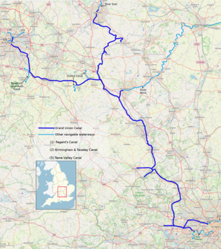
The Grand Union Canal in England is part of the British canal system. It is the principal navigable waterway between London and the Midlands. Starting in London, one arm runs to Leicester and another ends in Birmingham, with the latter stretching for 137 miles (220 km) with 166 locks from London. The Birmingham line has a number of short branches to places including Slough, Aylesbury, Wendover, and Northampton. The Leicester line has two short arms of its own, to Market Harborough and Welford.

<span class="mw-page-title-main">River Avon, Warwickshire</span> River in central England

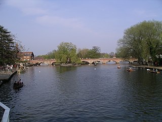
The River Avon in central England flows generally southwestwards and is a major left-bank tributary of the River Severn, of which it is the easternmost. It is also known as the Warwickshire Avon or Shakespeare's Avon, to distinguish it from several other rivers of the same name in the United Kingdom.

<span class="mw-page-title-main">Stratford-upon-Avon Canal</span>

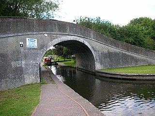
The Stratford-upon-Avon Canal is a canal in the south Midlands of England. The canal, which was built between 1793 and 1816, runs for 25.5 miles (41.0 km) in total, and consists of two sections. The dividing line is at Kingswood Junction, which gives access to the Grand Union Canal. Following acquisition by a railway company in 1856, it gradually declined, the southern section being un-navigable by 1945, and the northern section little better.

<span class="mw-page-title-main">Worcester and Birmingham Canal</span> Canal in the United Kingdom

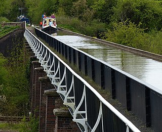
The Worcester and Birmingham Canal is a canal linking Birmingham and Worcester in England. It starts in Worcester, as an 'offshoot' of the River Severn and ends in Gas Street Basin in Birmingham. It is 29 miles (47 km) long. There are 58 locks in total on the canal, including the 30 Tardebigge Locks, one of the longest lock flights in Europe. The canal climbs 428 feet (130 m) from Worcester to Birmingham.

<span class="mw-page-title-main">Warwickshire ring</span>

The Warwickshire ring is a connected series of canals forming a circuit around the West Midlands area of England. The ring is formed from the Coventry Canal, the Oxford Canal, the Grand Union Canal, the Stratford-upon-Avon Canal and the Birmingham and Fazeley Canal. It is a popular route with tourists due to its circular route and mixture of urban and rural landscapes.

<span class="mw-page-title-main">Stourbridge Canal</span> Canal in England

The Stourbridge Canal is a canal in the West Midlands of England. It links the Staffordshire and Worcestershire Canal with the Dudley Canal, and hence, via the Birmingham Canal Navigations, to Birmingham and the Black Country.

<span class="mw-page-title-main">Stourport Ring</span>

The Stourport Ring is a connected series of canals forming a circuit, or canal ring, around Worcestershire, The Black Country and Birmingham in The Midlands, England. The ring is formed from the River Severn, the Staffordshire and Worcestershire Canal, the Stourbridge Canal, the Dudley Canals, the Birmingham Canal Navigations and the Worcester and Birmingham Canal.

<span class="mw-page-title-main">Autherley Junction</span>

Autherley Junction is the name of the canal junction where the Shropshire Union Canal terminates and meets the Staffordshire and Worcestershire Canal near to Oxley, north Wolverhampton, West Midlands, England.

<span class="mw-page-title-main">Water levels of the Birmingham Canal Navigations</span>

The Birmingham Canal Navigations (BCN), a network of narrow canals in the industrial midlands of England, is built on various water levels. The three longest are the Wolverhampton, Birmingham, and Walsall levels. Locks allow boats to move from one level to another.

<span class="mw-page-title-main">Tardebigge Locks</span>

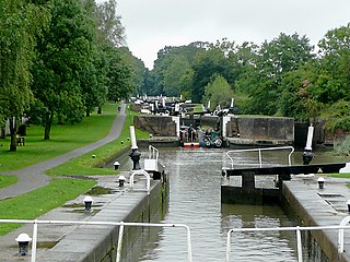
Tardebigge Locks or the Tardebigge Flight is the longest flight of locks in the UK, comprising 30 narrow locks on a two-and-a-quarter-mile (3.6 km) stretch of the Worcester and Birmingham Canal at Tardebigge, Worcestershire. It raises the waterway 220 feet (67 m), and lies between the Tardebigge tunnel to the North and the Stoke Prior flight of six narrow locks to the South. The Tardebigge Engine House is also on this stretch.

<span class="mw-page-title-main">Kings Norton Junction</span> Kings Norton Canal Junction

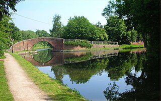
Kings Norton Junction is the name of the canal junction where the Stratford-upon-Avon Canal terminates and meets the Worcester and Birmingham Canal at Kings Norton, Birmingham, England.

<span class="mw-page-title-main">South Pennine Ring</span>

The South Pennine Ring is an English canal ring which crosses the Pennines between Manchester and Huddersfield. It covers parts of five canals, and includes passage through the longest canal tunnel in Britain. It has only been possible to cruise it since 2002, when restoration of the Huddersfield Narrow Canal provided the return route across the Pennines.

<span class="mw-page-title-main">Four Counties Ring</span>

The Four Counties Ring is a canal ring which links the four English counties of Cheshire, Staffordshire, Shropshire and West Midlands.

<span class="mw-page-title-main">North Pennine Ring</span>

The North Pennine Ring is a canal ring which crosses the Pennines between Manchester, Leeds and Castleford. It follows parts of five canals, and shares much of its route with the Outer Pennine Ring, which uses a different route for the southern crossing of the Pennines.

<span class="mw-page-title-main">Outer Pennine Ring</span>

The Outer Pennine Ring is an English canal ring which crosses the Pennines between Manchester, Leeds and Castleford. Its route follows parts of eight canals, and includes the longest canal tunnel in England. The ring was completed in 2001, with the opening of the Huddersfield Narrow Canal. Much of the route is shared with the North Pennine Ring, which crosses the Pennines by a different route on the southern leg.

<span class="mw-page-title-main">Rushall Junction</span> Canal junction

Rushall Junction is the southern limit of the Rushall Canal where it meets the Tame Valley Canal in the West Midlands, England. It opened in 1847, when the Rushall Canal was built to create connections between the Birmingham Canal Navigations system and the Wyrley and Essington Canal, following the amalgamation of the two companies in 1840.

<span class="mw-page-title-main">Rumer Hill Junction</span> Canal junction in England

Rumer Hill Junction was a canal junction on the Cannock Extension Canal where the Churchbridge Branch left to join the Hatherton Canal. The junction, along with the northern section of the canal was abandoned in 1963. The Churchbridge Branch and Rumer Hill Junction were subsequently obliterated by opencast mining.

<span class="mw-page-title-main">Kingswood Junction</span>

Kingswood Junction is a canal junction where the Stratford-upon-Avon Canal meets the Grand Union Canal at Kingswood, Warwickshire, England.

<span class="mw-page-title-main">Delph Locks</span>

Delph Locks or the Delph Nine are a series of eight narrow canal locks on the Dudley No. 1 Canal in Brierley Hill, in the West Midlands, England. They were opened in 1779, and reopened in 1967 following restoration of the Dudley Canal and the Stourbridge Canal in a joint venture between the Staffordshire and Worcestershire Canal Society and the British Waterways Board.

<span class="mw-page-title-main">Shrewley Tunnel</span>

Shrewley Tunnel is a canal tunnel near Shrewley, Warwickshire, England, which opened in 1799. It became part of the Grand Union Canal in 1929.

References

  1. Shead 2004, p. 56.
  2. Cumberlidge 2009, p. 48.
  3. Nicholson 2006, p. 11.
  4. Cumberlidge 2009, p. 266.
  5. Nicholson 2006, pp. 85–91.
  6. Nicholson 2006, pp. 152–153.
  7. Nicholson 2006, p. 157.
  8. Nicholson 2006, pp. 158–159.
  9. Nicholson 2006, p. 163.
  10. Nicholson 2006, p. 165.
  11. Cumberlidge 2009, p. 338.
  12. Nicholson 2006, pp. 138–139.
  13. Nicholson 2006, pp. 140–143.
  14. Nicholson 2006, pp. 143–145.
  15. Nicholson 2006 , pp. 146–147
  16. Nicholson 2006, p. 136.

52°11′32″N1°42′12″W / 52.1922°N 1.7032°W / 52.1922; -1.7032 (Junction at Statford-on-Avon)