Strahan, Iowa | |
|---|---|
 Strahan, Iowa | |
| Coordinates: Coordinates: 40°56′59″N95°29′57″W / 40.9497201°N 95.4991631°W | |
| Country | United States |
| State | Iowa |
| County | Mills |
| Time zone | UTC-6 (Central (CST)) |
| • Summer (DST) | CDT |
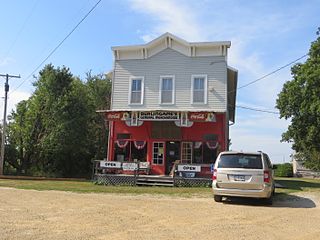
Strahan was a town in Mills County, Iowa.
Strahan, Iowa | |
|---|---|
| Strahan, Iowa | |
| Coordinates: Coordinates: 40°56′59″N95°29′57″W / 40.9497201°N 95.4991631°W | |
| Country | United States |
| State | Iowa |
| County | Mills |
| Time zone | UTC-6 (Central (CST)) |
| • Summer (DST) | CDT |
Strahan was a town in Mills County, Iowa.
Founded in the 1800s, Strahan's population was 21 in 1902, [1] and 82 in 1925. [2]

Dudley is a ghost town in Wapello County, Iowa, United States. Both 1908 and 1920 surveys of northwestern Wapello County show a post office at Dudley. A sign on the former edge of town reads: "Population 12 and God only knows how many dogs and cats."
Bladensburg is a small unincorporated community in Wapello County, Iowa, United States. It lies midway between Agency and Batavia at a distance of five miles (8 km) from each, and the largest nearby city is Ottumwa, seven miles (11 km) to the west-southwest.
Washburn is an unincorporated town and census-designated place (CDP) in Black Hawk County, Iowa, United States. Washburn lies south of Waterloo on U.S. Route 218. Other towns near Washburn are Gilbertville and La Porte City. The community is part of the Waterloo–Cedar Falls Metropolitan Statistical Area.
Elvira is an unincorporated community in Clinton County, Iowa, United States. It falls within the Clinton zip code (52732).
Dewar is an unincorporated town in eastern Black Hawk County, Iowa, United States. It lies northeast of the city of Waterloo, the county seat of Black Hawk County. Its elevation is 889 feet (271 m). Although Dewar is unincorporated, it has a post office with the ZIP code of 50623, which opened on 25 October 1887.
Killduff is an unincorporated community in southeastern Jasper County, Iowa, United States. It lies along local roads southeast of the city of Newton, the county seat of Jasper County.
Conroy is an unincorporated community and census-designated place (CDP) in central Iowa County, Iowa, United States. It lies along local roads southeast of the city of Marengo, the county seat of Iowa County. Its elevation is 879 feet (268 m). Conroy has a post office with the ZIP code of 52220, which opened on 5 January 1885. As of the 2010 census the population was 259.
Froelich is an unincorporated community in Clayton County, Iowa, United States.
Allendorf is an unincorporated community in Osceola County, Iowa, United States. It is located on Highway 59, five miles east of Sibley, at 43.413270N, -95.64318W, adjacent to the Johnson Wilderness Area.
Avon is an unincorporated community in Polk County, Iowa, United States. Avon was previously known as Watts Cemetery.

Downey is an unincorporated community in Cedar County, Iowa.
Centerdale is an unincorporated community in Cedar County, Iowa, United States.
Plato is an unincorporated community in Cedar County, Iowa, United States. Plato is located at 41°44′17″N91°18′31″W.
Buchanan is an unincorporated community in Cedar County, Iowa, United States.
Jacksonville is an unincorporated community and census-designated place in Jackson Township, Shelby County, Iowa, in the United States. As of the 2010 Census the population of Jacksonville was 30.
May City is an unincorporated community in Osceola County, Iowa, United States.
Walnut City is an unincorporated community in Appanoose County, Iowa, United States.
Cleves, Iowa, is a small town in north central Iowa with a bank, a repair shop, and a grain elevator. Cleves is in Hardin County, Iowa.
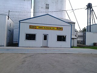
Edna is an unincorporated town in Lyon County, Iowa, United States. Edna is located on the western border of Liberal Township in Lyon County. It is located 6 miles (10 km) southeast of Rock Rapids, the county seat.
Canby is an unincorporated community in Adair County, in the U.S. state of Iowa.
| | This article about the geography of Mills County, Iowa is a stub. You can help Wikipedia by expanding it. |