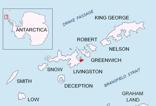
The South Shetland Islands are a group of Antarctic islands with a total area of 3,687 km2 (1,424 sq mi). They lie about 120 kilometres north of the Antarctic Peninsula, and between 430 and 900 km southwest of the nearest point of the South Orkney Islands. By the Antarctic Treaty of 1959, the islands' sovereignty is neither recognized nor disputed by the signatories and they are free for use by any signatory for non-military purposes.

The Fildes Peninsula is a 7 km (4.3 mi) long peninsula that forms the south-western end of King George Island in the South Shetland Islands of Antarctica. It was named from association with nearby Fildes Strait by the UK Antarctic Place-Names Committee in 1960; the strait was likely named for Robert Fildes, a British sealer of the 1800s.

Admiralty Bay is an irregular bay, 8 km (5 mi) wide at its entrance between Demay Point and Martins Head, indenting the southern coast of King George Island for 16 km (10 mi), in the South Shetland Islands of Antarctica. The name appears on a map of 1822 by Captain George Powell, a British sailor, and is now established in international usage. The Henryk Arctowski Polish Antarctic Station is situated on the bay, as is the Comandante Ferraz Brazilian Antarctic Base. It has been designated an Antarctic Specially Managed Area.

Magura Glacier on the southeast side of Tangra Mountains on Livingston Island in the South Shetland Islands, Antarctica is located to the north of M'Kean Point, northeast of Srebarna Glacier, south of Iskar Glacier and southwest of Dobrudzha Glacier. It is bounded by Great Needle Peak to the west, Vitosha Saddle, Vihren Peak and Helmet Peak to the northwest, Plovdiv Peak and Shishman Peak to the north, and Devin Saddle and Kuber Peak to the northeast. The glacier extends 3.5 km in southwest-northeast direction and 1.9 km in northwest-southeast direction, and flows southeastward into Bransfield Strait.

The Syrezol Rocks are a small group of marine rocks lying 1 mile (1.6 km) west of Martins Head at the east side of the entrance to Admiralty Bay, near King George Island in the South Shetland Islands. In 1908–1910, the Fourth French Antarctic Expedition under Jean-Baptiste Charcot assigned the name "Cap Syrezol" to a feature between what is now Martins Head and Chabrier Rock. Since there is no distinctive point or cape in this position, the name has been applied to these rocks in order to preserve Charcot's naming in the area in which it was originally given.

Telefon Rocks is a group of rocks 1.5 miles (2.4 km) south-southwest of Demay Point, and just east of Telefon Point, at the west side of the entrance to Admiralty Bay, King George Island, in the South Shetland Islands. Named after the Telefon, a vessel which went aground and was abandoned there in 1908.

Krivodol Glacier is a 3.8 km long glacier on Smith Island, South Shetland Islands in Antarctica draining the southeast slopes of Imeon Range northeast and east of Antim Peak, southeast of Varshets Saddle and south of Slatina Peak. It is situated southwest of Ovech Glacier and northeast of Pashuk Glacier, and flows southeastward into Osmar Strait northeast of Sredets Point. Bulgarian early mapping in 2009. The glacier is named after the town of Krivodol in northwestern Bulgaria.

McFarlane Strait is a strait lying between Greenwich Island and Livingston Island, in the South Shetland Islands off Antarctica. It is 24 kilometres (13 nmi) long and 3 kilometres (1.6 nmi) wide. The name appears on an 1822 chart by Captain George Powell, a British sealer, and is now well established in international usage.

Renier Point is a narrow point forming the east extremity of both Burgas Peninsula and Livingston Island in the South Shetland Islands, Antarctica. The feature was known to sealers as Point Renier as early as 1821. The name ‘Pin Point’, given by Discovery Investigations personnel on the Discovery II in 1935, has been rejected in favor of the original name.

Usher Glacier is a glacier nearly 4 nautical miles (7 km) long, flowing northwest into the sea between Stigant Point and Davey Point on the north coast of King George Island, in the South Shetland Islands. Named by the United Kingdom Antarctic Place-Names Committee (UK-APC) in 1960 for J. Usher, Master of the Caraquet from Liverpool, who visited the South Shetland Islands in 1821–22.

Napier Rock is a rock lying 1.75 nautical miles (3.2 km) east-southeast of Point Thomas in Admiralty Bay, King George Island, in the South Shetland Islands. Charted by the French Antarctic Expedition under Charcot, 1908–10. Named by the United Kingdom Antarctic Place-Names Committee (UK-APC) in 1960 for Ronald G. Napier (1925–1956) of Falkland Islands Dependencies Survey (FIDS), general assistant and handyman at the Signy Island station in 1955, and then leader at Admiralty Bay until he was drowned on March 24, 1956.
Suffield Point is the south-west entrance point of Norma Cove, Fildes Peninsula, on King George Island in the South Shetland Islands of Antarctica. It was charted in the course of the Discovery Investigations, 1933–35, and named after boatswain William E. Suffield. The site is part of the Fildes Peninsula Antarctic Specially Protected Area, designated as such because of its paleontological values.

Potter Peninsula is a low ice-free peninsula between Potter Cove and Stranger Point in south-west King George Island, in the South Shetland Islands of Antarctica. It is protected as ASPA 132, largely because of the richness and diversity of its flora and fauna.

Point Hennequin is a point forming the eastern side of the entrance to Martel Inlet and Mackellar Inlet, on the east side of Admiralty Bay, King George Island, in the South Shetland Islands. It was named by the French Antarctic Expedition under Jean-Baptiste Charcot, who surveyed Admiralty Bay in 1909.

Lange Glacier is a glacier flowing into the west side of Admiralty Bay close south of Admiralen Peak, King George Island, in the South Shetland Islands, Antarctica. It was charted by the French Antarctic Expedition, 1908–10, under Jean-Baptiste Charcot, and was named by the UK Antarctic Place-Names Committee in 1960 for Alexander Lange (1860–1922), a Norwegian pioneer of modern steam whaling in the South Shetland Islands in 1905–6, and commander of the Admiralen.
Harmony Cove is a cove entered between Harmony Point and The Toe on the west side of Nelson Island, in the South Shetland Islands, Antarctica. It was named by American sealers in about 1820 after the sealing vessel Harmony, under Captain Thomas Ray, one of several American sealing vessels headquartered at Harmony Cove during the 1820–21 season.

Rotalia Island is the rocky island off the north coast of Nelson Island in the South Shetland Islands, Antarctica extending 310 m in southeast-northwest direction and 250 m in southwest-northeast direction.

Kondor Island is the 320 m long in west–east direction and 140 m wide rocky island lying off the north coast of Nelson Island in the South Shetland Islands, Antarctica.

Fregata Island is the 480 m long in southeast-northwest direction and 230 m wide rocky island lying off the north coast of Nelson Island in the South Shetland Islands, Antarctica.
Odometer Rock is the rock off the NW coast of northwest coast of Nelson Island in the South Shetland Islands, Antarctica extending 40 m in west–east direction and 30 m in south–north direction. Its surface area is 0.07 ha. The vicinity was visited by early 19th century sealers.
![]() This article incorporates public domain material from "Stranger Point". Geographic Names Information System . United States Geological Survey. Coordinates: 62°15′42″S58°37′03″W / 62.26175°S 58.61756°W
This article incorporates public domain material from "Stranger Point". Geographic Names Information System . United States Geological Survey. Coordinates: 62°15′42″S58°37′03″W / 62.26175°S 58.61756°W 


