Stranraer Sheriff Court

Last updated

Stranraer Sheriff Court
Stranraer Sheriff Court - geograph.org.uk - 862324.jpg
Stranraer Sheriff Court
LocationLewis Street, Stranraer
Coordinates 54°54′10″N5°01′39″W / 54.9029°N 5.0276°W / 54.9029; -5.0276 Coordinates: 54°54′10″N5°01′39″W / 54.9029°N 5.0276°W / 54.9029; -5.0276
Built1874
Architect Thomas Brown II and James Maitland Wardrop
Architectural style(s) Gothic Revival style
Listed Building – Category B
Official nameStranraer Sheriff Court and Justice of the Peace Court, including war memorial, gatepiers and boundary walls, Lewis Street, Stranraer
Designated20 July 1972
Reference no.LB41785
Dumfries and Galloway UK location map.svg
Red pog.svg
Shown in Dumfries and Galloway

Stranraer Sheriff Court is a judicial building in Lewis Street, Stranraer, Dumfries and Galloway, Scotland. The building, which continues to be used as a courthouse, is a Category B listed building. [1]

Contents

History

The war memorial outside the sheriff court War Memorial, Stranraer (geograph 7243072).jpg
The war memorial outside the sheriff court

The first judicial building in Stranraer was a tolbooth which was built on part of the local parish churchyard and dated back to the late 17th century. It was replaced, in 1776, by the old town hall in George Street, which was extended to the rear to accommodate a corn exchange and a courtroom in 1855. [2] However, in the early 1870s, the Commissioners of Supply decided that Stranraer need a dedicated courthouse. A new courthouse was designed by Thomas Brown II and James Maitland Wardrop in the Gothic Revival style, built in red sandstone from Galashiels with buff stone dressings from Hexham and was officially opened on 15 January 1874. [1]

The design involved a symmetrical main frontage of three bays facing into Lewis Street. The central bay featured a portico, which incorporated an arch with a hood mould and supported a balcony with a balustrade; there were tripartite lancet windows on the first floor. The outer bays were fenestrated by sash windows with architraves on the ground floor and by bi-partite lancet windows on the first floor. At roof level, there were stepped gables above all three bays: the central gable contained a panel carved with the Stranraer coat of arms, while the outer gables contained small lancet windows. Internally, the principal room was the main courtroom on the first floor. [1]

Following the implementation of the Local Government (Scotland) Act 1889, which established county councils in every county, Wigtownshire County Council held its first meeting at Wigtown County Buildings in The Square at Wigtown on 22 May 1890, when it was decided to hold the council's annual meeting each May at Wigtown, but other meetings were to be held alternately at Stranraer and Newton Stewart. [3] [4] [5] The council later established its main offices at Ashwood House on Sun Street, Stranraer, close to the Sheriff Court on Lewis Street which was the council's meeting place when it met in Stranraer. [6]

A war memorial, in the form of a soldier from the Royal Scots Fusiliers wearing a Tam o' shanter mounted on a granite pedestal, which was intended to commemorate the lives of local service personnel who had died in the First World War, was unveiled outside the sheriff court in 1920. [7] [8] [9]

After the abolition of Wigtownshire County Council in 1975, the building continued to serve a judicial function, being used for hearings of the sheriff's court and, on one day a month, for hearings of the justice of the peace court. It was extensively refurbished in 1981. [10] It was reported, in August 2022, that the courthouse needed repairs expected to cost some £200,000 including a replacement boiler as well as a survey of the drainage system. [11]

See also

Related Research Articles

<span class="mw-page-title-main">Dumfries and Galloway</span> Council area of Scotland

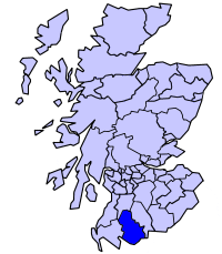
Dumfries and Galloway is one of 32 unitary council areas of Scotland and is located in the western Southern Uplands. It covers the historic counties of Dumfriesshire, Kirkcudbrightshire, and Wigtownshire, the latter two of which are collectively known as Galloway. The administrative centre and largest settlement is the town of Dumfries. The second largest town is Stranraer, on the North Channel coast, some 57 miles (92 km) to the west of Dumfries.

<span class="mw-page-title-main">Wigtown</span> Human settlement in Scotland

Wigtown is a town and former royal burgh in Wigtownshire, of which it is the county town, within the Dumfries and Galloway region in Scotland. It lies east of Stranraer and south of Newton Stewart. It is known as "Scotland's National Book Town" with a high concentration of second-hand book shops and an annual book festival.

<span class="mw-page-title-main">Stranraer</span> Town and sea port in Scotland

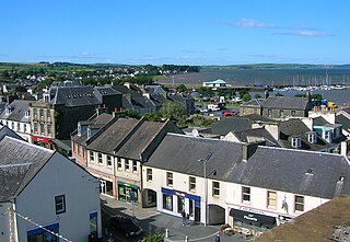
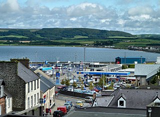
Stranraer, also known as The Toon, is a town in Dumfries and Galloway, Scotland. It is located in the historical parish of Inch in the historic county of Wigtownshire. It lies on the shores of Loch Ryan, on the northern side of the isthmus joining the Rhins of Galloway to the mainland. Stranraer is Dumfries and Galloway's second-largest town, with a population including the immediate surrounding area of nearly 13,000 inhabitants.

<span class="mw-page-title-main">Kirkcudbrightshire</span> Historic county in Scotland

Kirkcudbrightshire, or the County of Kirkcudbright or the Stewartry of Kirkcudbright is one of the historic counties of Scotland, covering an area in the south-west of the country. Until 1975, Kirkcudbrightshire was an administrative county used for local government. Since 1975, the area has formed part of Dumfries and Galloway for local government purposes. Kirkcudbrightshire continues to be used as a registration county for land registration. A lower-tier district called Stewartry covered the majority of the historic county from 1975 to 1996. The area of Stewartry district is still used as a lieutenancy area. Dumfries and Galloway Council also has a Stewartry area committee.

<span class="mw-page-title-main">Wigtownshire</span> Historic county in Scotland

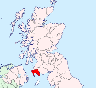
Wigtownshire or the County of Wigtown is one of the historic counties of Scotland, covering an area in the south-west of the country. Until 1975, Wigtownshire was an administrative county used for local government. Since 1975 the area has formed part of Dumfries and Galloway for local government purposes. Wigtownshire continues to be used as a territory for land registration, being a registration county. The historic county is all within the slightly larger Wigtown Area, which is one of the lieutenancy areas of Scotland and was used in local government as the Wigtown District from 1975 to 1996.

<span class="mw-page-title-main">Stewartry</span> Scottish lieutenancy area and former local government district

Stewartry was a local government district from 1975 until 1996 within the Dumfries and Galloway region in south-west Scotland. Under the name Stewartry of Kirkcudbright the area of the former district is still used as a lieutenancy area. Dumfries and Galloway Council has a Stewartry area committee which approximately covers the same area, subject to some adjustments where ward boundaries no longer follow the pre-1996 district boundary. Stewartry covers the majority of the historic county of Kirkcudbrightshire, and derives its name from the county's alternative name of the "Stewartry of Kirkcudbright".

<span class="mw-page-title-main">Wigtown Area</span> Scottish lieutenancy area and former local government district

Wigtown is a lieutenancy area in south-west Scotland and a committee area of Dumfries and Galloway Council. From 1975 until 1996 it was also a local government district. It closely resembles the historic county of Wigtownshire, covering the whole area of that county but also including the two parishes of Kirkmabreck and Minnigaff from the historic county of Kirkcudbrightshire.

<span class="mw-page-title-main">Inch, Dumfries and Galloway</span> Human settlement in Scotland

Inch is a civil parish in Dumfries and Galloway, southwest Scotland. It lies on the shore of Loch Ryan, in the traditional county of Wigtownshire.

<span class="mw-page-title-main">Wigtown County Buildings</span> Municipal building in Wigtown, Scotland

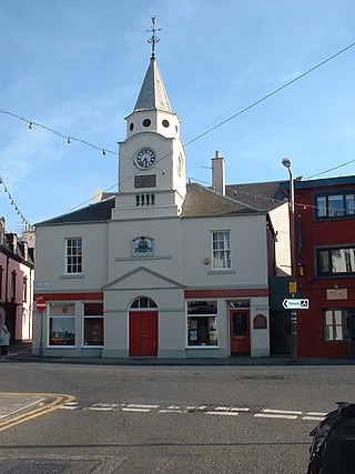
Wigtown County Buildings, also known as Wigtown County Buildings and Town Hall, is a municipal building in The Square, Wigtown, Scotland. The structure primarily served as the meeting place and town hall for Wigtown Burgh Council, but was also used for some meetings of Wigtownshire County Council. It is a Category B listed building.

<span class="mw-page-title-main">Old Town Hall, Stranraer</span> Municipal building in Stranraer, Scotland

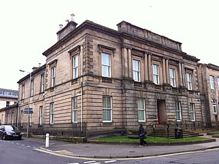
The Old Town Hall is a municipal structure in George Street, Stranraer, Dumfries and Galloway, Scotland. The structure, which is used as a local history museum, is a Category A listed building.

<span class="mw-page-title-main">County Buildings, Kirkcudbright</span> County building in Kirkcudbright, Scotland

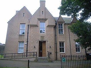
County Buildings is a municipal building in Kirkcudbright, in the Dumfries and Galloway council area in Scotland. It was originally two houses on High Street, which then served as the main offices of Kirkcudbrightshire County Council from 1925 to 1975. A large extension to the rear was added in 1952, accessed from Daar Road. From 1975 until 1996 the building served as the offices of Stewartry District Council. Since 1996, it has been an area office of Dumfries and Galloway Council. It is a Category B listed building. Prior to the 1952 extension the name "County Buildings" was used for a different building, at 85 High Street, which was also the town's sheriff court.

<span class="mw-page-title-main">Elgin Sheriff Court</span> Courthouse in Elgin, Scotland

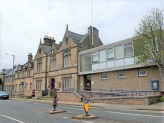
Elgin Sheriff Court is a municipal structure in the High Street, Elgin, Moray, Scotland. The structure, which was the headquarters of Morayshire County Council and remains in use as a courthouse, is a Category B listed building.

<span class="mw-page-title-main">Kirkwall Sheriff Court</span> Courthouse in Kirkwall, Scotland

Kirkwall Sheriff Court is a judicial structure in Watergate, Kirkwall, Orkney, Scotland. The structure, which was the headquarters of Orkney County Council and is currently used as a courthouse, is a Category C listed building.

<span class="mw-page-title-main">Dingwall Sheriff Court</span> Courthouse in Dingwall, Scotland

Dingwall Sheriff Court is a former judicial structure in the High Street, Dingwall, Highland, Scotland. The complex, which was used as the headquarters of Ross and Cromarty County Council as well as the local courthouse before being converted for residential use in 2015, is a Category B listed building.

<span class="mw-page-title-main">County Buildings, Duns</span> Courthouse in Duns, Scotland

County Buildings is a municipal structure in Newtown Street, Duns, Scottish Borders, Scotland. The complex, which was the headquarters of Berwickshire County Council and was also used as a courthouse, is a Category C listed building.

<span class="mw-page-title-main">County Buildings, Selkirk</span> Courthouse in Duns, Scotland

County Buildings is a municipal structure in Ettrick Terrace, Selkirk, Scottish Borders, Scotland. The complex, which was the headquarters of Selkirkshire County Council and was also used as a courthouse, is a Category B listed building.

<span class="mw-page-title-main">County Buildings, Alloa</span> County building in Alloa, Scotland

County Buildings is a municipal structure in Drysdale Street, Alloa, Clackmannanshire, Scotland. The structure, which was the headquarters of Clackmannanshire County Council and is currently used as courthouse, is a Category B listed building.

<span class="mw-page-title-main">Wick Sheriff Court</span> Judicial building in Wick, Scotland

Wick Sheriff Court is a judicial structure in Bridge Street, Wick, Caithness, Scotland. The structure, which remains in use as a courthouse, is a Category B listed building.

<span class="mw-page-title-main">Stonehaven Sheriff Court</span> Judicial building in Stonehaven, Scotland

Stonehaven Sheriff Court, formerly known as County Buildings, is a judicial structure in Dunnottar Avenue, Stonehaven, Aberdeenshire, Scotland. The structure, which was used as the headquarters of Kincardineshire County Council as well as a courthouse, is a Category B listed building.

References

  1. 1 2 3 Historic Environment Scotland. "Stranraer Sheriff Court and Justice of the Peace Court, including war memorial, gatepiers and boundary walls, Lewis Street, Stranraer (LB41785)" . Retrieved 26 December 2022.
  2. "Stranraer Town House". Scran. Retrieved 10 November 2021.
  3. "County Meetings". Galloway Gazette. Newton Stewart. 24 May 1890. p. 3. Retrieved 24 November 2022.
  4. "Wigtown County Buildings". Future Museum. Retrieved 2 August 2021.
  5. Historic Environment Scotland. "Wigtown Town Hall (Former Wigtown Sheriff Court), The Square, Wigtown (LB42439)" . Retrieved 18 July 2021.
  6. "No. 14265". The Edinburgh Gazette . 7 September 1926. p. 1006.
  7. "Stranraer". Imperial War Museum. Retrieved 26 December 2022.
  8. "Stranraer War Memorial". Memorials Online. Retrieved 26 December 2022.
  9. "War Memorial Stranraer". Traces of War. Retrieved 26 December 2022.
  10. "Stranraer Sheriff Court and Justice of the Peace Court". Scottish Courts and Tribunals. Retrieved 27 December 2022.
  11. "State of Dumfries Sheriff Court building described as "crumbling"". Daily Record. 25 August 2022. Retrieved 26 December 2022.