Stroe, Gelderland

Last updated
Stroe
RM523203 Zaadeestgebouw Stroe.JPG
Seed pit building
Stroe vlag.png
2010-NL-P05-Gelderland-positiekaart-gemnamen.jpg
Red pog.svg
Stroe
Location in the province of Gelderland
Netherlands location map.svg
Red pog.svg
Stroe
Stroe (Netherlands)
Coordinates: 52°11′7″N5°41′28″E / 52.18528°N 5.69111°E / 52.18528; 5.69111
Country Netherlands
Province Gelderland
Municipality Barneveld
Area
[1]
  Total
30.65 km2 (11.83 sq mi)
Elevation
[2]
19 m (62 ft)
Population
 (2021) [1]
  Total
2,170
  Density70.8/km2 (183/sq mi)
Time zone UTC+1 (CET)
  Summer (DST) UTC+2 (CEST)
Postal code
3776 [1]
Dialing code 0342

Stroe is a village in the Dutch province of Gelderland. It is located in the municipality of Barneveld, between the towns of Barneveld and Apeldoorn. [3]

Contents

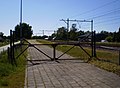
Stroe is located on the railway line between these two towns, but the railway station closed in 1944. [4]

History

It was first mentioned in 1296 as "Wlfumdus de Struode", and means "swamp with overgrowth". [5] In 1840, it was home to 122 people. In 1966, a village house was opened in Stroe. [6] In 1951, the army base Wittenberg was constructed near Stroe. In 1978, it was renamed Major-General Koot Barracks after Henri Koot  [ nl ]. [7]

References

  1. 1 2 3 "Kerncijfers wijken en buurten 2021". Central Bureau of Statistics. Retrieved 19 March 2022.
  2. "Postcodetool for 3776LM". Actueel Hoogtebestand Nederland (in Dutch). Het Waterschapshuis. Retrieved 19 March 2022.
  3. ANWB Topografische Atlas Nederland, Topografische Dienst and ANWB, 2005.
  4. "Station Stroe". Stationsweb (in Dutch). Retrieved 19 March 2022.
  5. "Stroe - (geografische naam)". Etymologiebank (in Dutch). Retrieved 19 March 2022.
  6. "Stroe". Plaatsengids (in Dutch). Retrieved 19 March 2022.
  7. "De Generaal-majoor Kootkazerne is vijftig jaar later nog altijd in gebruik" (in Dutch). 10 August 2021. Retrieved 19 March 2022.