Kootwijkerbroek

Last updated
Kootwijkerboek
GG Kootwbr-achter.jpg
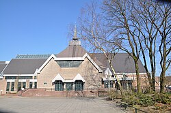
The church of the Reformed Congregations. (1,750 seats)
2010-NL-P05-Gelderland-positiekaart-gemnamen.jpg
Red pog.svg
Kootwijkerboek
Location in the province of Gelderland
Netherlands location map.svg
Red pog.svg
Kootwijkerboek
Kootwijkerboek (Netherlands)
Coordinates: 52°09′N5°40′E / 52.150°N 5.667°E / 52.150; 5.667 Coordinates: 52°09′N5°40′E / 52.150°N 5.667°E / 52.150; 5.667
Country Netherlands
Province Gelderland
Municipality Barneveld
Area
[1]
  Total24.74 km2 (9.55 sq mi)
Elevation
[2]
16 m (52 ft)
Population
 (2021) [1]
  Total5,740
  Density230/km2 (600/sq mi)
Time zone UTC+1 (CET)
  Summer (DST) UTC+2 (CEST)
Postal code
3774 [1]
Dialing code 0342

Kootwijkerbroek is a village in the Netherlands, on the Veluwe, in the municipality of Barneveld, Gelderland, Netherlands. The village, situated in the Gelderland Valley, east of Barneveld, has a major agricultural role in this part of the valley with most of the 157 companies located in Kootwijkerbroek involved in agriculture and industry. Kootwijkerbroek is an old village just between Kootwijk and Barneveld, with many generations traditionally involved in milling. The last mill burnt down in 1964, however it was rebuilt in 2015. [3] On the edge of the village, there is a church with a beautiful old vicarage surrounded by an attractive garden park with ponds.

Kootwijkerbroek is a conservative Protestant village, located on the Dutch Bible Belt. In the 2010 municipal elections, 52 percent of the local population voted for the Reformed Political Party (SGP). The three Christian parties in the elections (the Reformed Political Party, the ChristianUnion and the Christian Democratic Appeal) had a combined total of almost 70 percent of the votes. Many of the socio demographic indicators reflect the conservative nature of the community, with relatively larger household families with young children and low divorce rates. [4]

Hundreds of farmers protested in 2001 in the village of Kootwijkerbroek. They tried to prevent the slaughter of healthy cattle as a result of foot-and-mouth disease restrictions. The farmers never accepted the verdict by the authorities that the disease had spread to the 'Teunissen' farm, as the alleged outbreak never spread beyond the suspected veal calf operation. In every other outbreak location in 2001, other surrounding farms were infected with animals showing evidence of the infection. The blockade involved about 200 farmers and was the largest protest related to the foot-and-mouth epidemic in the Netherlands.

Related Research Articles

De Glind Village in Gelderland, Netherlands

De Glind is a village near Barneveld in the middle of Netherlands, in the province Gelderland.

2001 United Kingdom foot-and-mouth outbreak Epidemic in 2001 in the UK

The outbreak of foot-and-mouth disease in the United Kingdom in 2001 caused a crisis in British agriculture and tourism. This epizootic saw 2,000 cases of the disease in farms across most of the British countryside. Over 6 million cows and sheep were killed in an eventually successful attempt to halt the disease. Cumbria was the worst affected area of the country, with 893 cases.

Lobith Village in Gelderland, Netherlands

Lobith is a village in the Dutch province of Gelderland. It is located in the municipality of Zevenaar. Traditionally, it is said that the Rhine enters the Netherlands at Lobith, although in reality, this happens about 4 km further upstream, near Spijk.

Angeren Village in Gelderland, Netherlands

Angeren is a village in the municipality of Lingewaard, Gelderland province, Netherlands. It has a population of 2,851, and is located in the very eastern tip of the Betuwe, 2 km to the south of Huissen, between the cities of Arnhem and Nijmegen.

Aagtekerke Place in Zeeland, Netherlands

Aagtekerke is a village in the Dutch province of Zeeland. It is a part of the municipality of Veere, and lies about 9 km (6 mi) northwest of Middelburg. In 2001, the village of Aagtekerke had 936 inhabitants. The built-up area was 22 ha, and contained 296 residences. The Aagtekerke statistical area, which includes the surrounding countryside and covers an area of 59 ha, has a population of around 1,245.

Nieuwer-Ter-Aa Village in Utrecht, Netherlands

Nieuwer-Ter-Aa is a village in the Dutch province of Utrecht (province). It is a part of the municipality of Stichtse Vecht, and lies about 13 km northwest of Utrecht.

Zoelmond Village in Gelderland, Netherlands

Zoelmond is a village in the Dutch province of Gelderland. It is a part of the municipality of Buren, and lies about 10 km northwest of Tiel.

Varik Village in Gelderland, Netherlands

Varik is a village in the Dutch province of Gelderland. It is a part of the municipality of West Betuwe, and lies about 8 km south of Tiel.

Alphen, Gelderland Village in Gelderland, Netherlands

Alphen is a village in the Dutch province of Gelderland. It is a part of the municipality of West Maas en Waal, and lies about 7 km north of Oss.

Garderen Place in Gelderland, Netherlands

Garderen is a village in the Dutch province of Gelderland. It is located in the municipality of Barneveld, in the forests of the Veluwe. The village has 1,994 inhabitants.

Stroe, Gelderland Village in Gelderland, Netherlands

Stroe is a village in the Dutch province of Gelderland. It is located in the municipality of Barneveld, between the towns of Barneveld and Apeldoorn.

The 1967 United Kingdom foot-and-mouth outbreak was a major outbreak of foot and mouth disease in the United Kingdom. The only centre of the disease, in contrast to the three concentrated areas in the 2001 crisis, was on the Wales border with Shropshire. France and other European countries were also affected by the crisis.

Uddel Village in Gelderland, Netherlands

Uddel is a village in the Netherlands, on the Veluwe, in the municipality of Apeldoorn, Gelderland, Netherlands. Uddel is located on the N310 from Elburg to Arnhem. The oldest mention of Uddel dates back to the year 792, as the settlement Uttiloch. The village had 2,927 inhabitants in 2016.

Restored Reformed Church

The Restored Reformed Church is a Calvinist denomination in the Netherlands. It was founded in 2004, from congregations which made up the orthodox-reformed wing of the Dutch Reformed Church; they had previously been part of groups named Het Gekrookte Riet and the still existing Gereformeerde Bond within the Dutch Reformed Church. The Church has grown steadily since its founding.

History of Wageningen History of town in Gelderland, Netherlands

The area around the town of Wageningen was settled as early as the 9th century. Located on the north bank of the Nederrijn river, between the Gelderse valley and the Veluwe, a wooded, hilly, glacial moraine, by the 12th century it was part of the Duchy of Guelders, in the Holy Roman Empire. Wageningen received its city charter from Count Otto II on June 12, 1263. Today, it is in the province of Gelderland, in east-central Netherlands.

Reformed Congregations in the Netherlands

The Reformed Congregations in the Netherlands is a pietistic Reformed church located mainly in the Netherlands, along with five congregations in North America and one in Pretoria, South Africa.

Elspeet Village in Gelderland, Netherlands

Elspeet is a tourist village in the Netherlands, in the Veluwe region, in the municipality of Nunspeet, Gelderland, Netherlands. The village is situated about 10 kilometers south of Nunspeet and about 4 kilometers north of Uddel, on the Northern Veluwe. It is surrounded by forest and heather. The village has 4,635 inhabitants.

Barneveld (town) Town in Gelderland, Netherlands

Barneveld is a town in the Dutch province of Gelderland and also the administrative center of the eponymous municipality.

Zieuwent Village in Gelderland, Netherlands

Zieuwent is a village in the Dutch province of Gelderland. It is a part of the municipality of Oost Gelre. Zieuwent has the tallest church tower of the Achterhoek region.

Dutch farmers protests 2019–2020 protest of farmers in the Netherlands

The 2019–2020 Dutch farmers protests is a series of civil disobedience demonstrations by Dutch livestock farmers, characterised by the usage of tractors to block roads, occupy public spaces and intimidate officials. The protests were initially triggered by a government proposal to limit nitrogen emissions in the Netherlands by halving the country's livestock, but protesting farmers have frequently told media that they are motivated by a perceived lack of respect for their profession by the Dutch populace, media and politicians.

References

  1. 1 2 3 "Kerncijfers wijken en buurten 2021". Central Bureau of Statistics. Retrieved 19 March 2022.
  2. "Postcodetool for 3774BA". Actueel Hoogtebestand Nederland (in Dutch). Het Waterschapshuis. Retrieved 19 March 2022.
  3. "Dutch Windmill Database | Puurveense Molen, Kootwijkerbroek".
  4. "Héél véél informatie over Kootwijkerbroek (Update 2021!)". 7 June 2021.