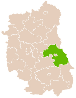
Gmina Żmudź is a rural gmina in Chełm County, Lublin Voivodeship, in eastern Poland. Its seat is the village of Żmudź, which lies approximately 20 kilometres (12 mi) south-east of Chełm and 81 km (50 mi) east of the regional capital Lublin.
Strzelce Landscape Park is a protected area in eastern Poland, on the border with Ukraine. The Park was established in 1983, and covers an area of 111.17 square kilometres (42.92 sq mi).

Białopole is a village in Chełm County, Lublin Voivodeship, in eastern Poland. It is the seat of the gmina called Gmina Białopole. It lies approximately 26 kilometres (16 mi) south-east of Chełm and 87 km (54 mi) east of the regional capital Lublin.
Busieniec is a village in the administrative district of Gmina Białopole, within Chełm County, Lublin Voivodeship, in eastern Poland. It lies approximately 4 kilometres (2 mi) south of Białopole, 28 km (17 mi) south-east of Chełm, and 87 km (54 mi) east of the regional capital Lublin.
Buśno is a village in the administrative district of Gmina Białopole, within Chełm County, Lublin Voivodeship, in eastern Poland. It lies approximately 28 kilometres (17 mi) south-east of Chełm and 89 km (55 mi) east of the regional capital Lublin.
Grobelki is a village in the administrative district of Gmina Białopole, within Chełm County, Lublin Voivodeship, in eastern Poland. It lies approximately 4 kilometres (2 mi) north-east of Białopole, 27 km (17 mi) south-east of Chełm, and 90 km (56 mi) east of the regional capital Lublin.
Kicin is a village in the administrative district of Gmina Białopole, within Chełm County, Lublin Voivodeship, in eastern Poland. It lies approximately 3 kilometres (2 mi) east of Białopole, 28 km (17 mi) south-east of Chełm, and 89 km (55 mi) east of the regional capital Lublin.
Kurmanów is a village in the administrative district of Gmina Białopole, within Chełm County, Lublin Voivodeship, in eastern Poland. It lies approximately 4 kilometres (2 mi) south of Białopole, 29 km (18 mi) south-east of Chełm, and 88 km (55 mi) east of the regional capital Lublin.
Raciborowice is a village in the administrative district of Gmina Białopole, within Chełm County, Lublin Voivodeship, in eastern Poland. It lies approximately 5 kilometres (3 mi) south-east of Białopole, 30 km (19 mi) south-east of Chełm, and 90 km (56 mi) east of the regional capital Lublin.
Zabudnowo is a village in the administrative district of Gmina Białopole, within Chełm County, Lublin Voivodeship, in eastern Poland. It lies approximately 26 kilometres (16 mi) south-east of Chełm and 89 km (55 mi) east of the regional capital Lublin.
Turka is a village in the administrative district of Gmina Dorohusk, within Chełm County, Lublin Voivodeship, in eastern Poland, close to the border with Ukraine. It lies approximately 4 kilometres (2 mi) south of Dorohusk, 23 km (14 mi) east of Chełm, and 87 km (54 mi) east of the regional capital Lublin.
Zagórnik is a village in the administrative district of Gmina Dubienka, within Chełm County, Lublin Voivodeship, in eastern Poland, close to the border with Ukraine. It lies approximately 9 kilometres (6 mi) south-east of Dubienka, 37 km (23 mi) south-east of Chełm, and 100 km (62 mi) east of the regional capital Lublin.
Alojzów is a village in the administrative district of Gmina Leśniowice, within Chełm County, Lublin Voivodeship, in eastern Poland. It lies approximately 5 kilometres (3 mi) east of Leśniowice, 20 km (12 mi) south of Chełm, and 75 km (47 mi) south-east of the regional capital Lublin.
Nowy Folwark is a village in the administrative district of Gmina Leśniowice, within Chełm County, Lublin Voivodeship, in eastern Poland. It lies approximately 3 kilometres (2 mi) south-west of Leśniowice, 21 km (13 mi) south of Chełm, and 70 km (43 mi) south-east of the regional capital Lublin.
Huta is a village in the administrative district of Gmina Wojsławice, within Chełm County, Lublin Voivodeship, in eastern Poland. It lies approximately 5 kilometres (3 mi) north-east of Wojsławice, 26 km (16 mi) south of Chełm, and 81 km (50 mi) south-east of the regional capital Lublin.
Gałęzów is a village in the administrative district of Gmina Żmudź, within Chełm County, Lublin Voivodeship, in eastern Poland. It lies approximately 12 kilometres (7 mi) north-east of Żmudź, 24 km (15 mi) east of Chełm, and 88 km (55 mi) east of the regional capital Lublin.
Kopyłów is a village in the administrative district of Gmina Horodło, within Hrubieszów County, Lublin Voivodeship, in eastern Poland, close to the border with Ukraine. It lies approximately 6 kilometres (4 mi) west of Horodło, 11 km (7 mi) north-east of Hrubieszów, and 106 km (66 mi) east of the regional capital Lublin.
Wielkopole is a village in the administrative district of Gmina Gorzków, within Krasnystaw County, Lublin Voivodeship, in eastern Poland. It lies approximately 5 kilometres (3 mi) north-east of Gorzków, 11 km (7 mi) west of Krasnystaw, and 45 km (28 mi) south-east of the regional capital Lublin.
Gruszka Duża is a village in the administrative district of Gmina Nielisz, within Zamość County, Lublin Voivodeship, in eastern Poland. It lies approximately 6 kilometres (4 mi) west of Nielisz, 23 km (14 mi) north-west of Zamość, and 57 km (35 mi) due south-east of the regional capital Lublin.