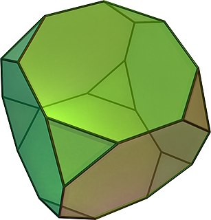
In geometry, the truncated cube, or truncated hexahedron, is an Archimedean solid. It has 14 regular faces, 36 edges, and 24 vertices.

Nowe Gagowy is a village in the administrative district of Gmina Lubień Kujawski, within Włocławek County, Kuyavian-Pomeranian Voivodeship, in north-central Poland. It lies approximately 4 kilometres (2 mi) north-east of Lubień Kujawski, 26 km (16 mi) south of Włocławek, and 78 km (48 mi) south-east of Toruń.
Przyruda is a village in the administrative district of Gmina Włocławek, within Włocławek County, Kuyavian-Pomeranian Voivodeship, in north-central Poland.
Jabłoń-Piotrowce is a village in the administrative district of Gmina Nowe Piekuty, within Wysokie Mazowieckie County, Podlaskie Voivodeship, in north-eastern Poland.
Białotarsk is a village in the administrative district of Gmina Gostynin, within Gostynin County, Masovian Voivodeship, in east-central Poland. It lies approximately 11 kilometres (7 mi) west of Gostynin and 118 km (73 mi) west of Warsaw.
Józefków is a village in the administrative district of Gmina Gostynin, within Gostynin County, Masovian Voivodeship, in east-central Poland.
Kleniew is a village in the administrative district of Gmina Gostynin, within Gostynin County, Masovian Voivodeship, in east-central Poland.
Lisica is a village in the administrative district of Gmina Gostynin, within Gostynin County, Masovian Voivodeship, in east-central Poland.
Podgórze is a village in the administrative district of Gmina Gostynin, within Gostynin County, Masovian Voivodeship, in east-central Poland. It lies approximately 4 kilometres (2 mi) north-east of Gostynin and 104 km (65 mi) west of Warsaw.
Sierakówek is a village in the administrative district of Gmina Gostynin, within Gostynin County, Masovian Voivodeship, in east-central Poland. It lies approximately 6 kilometres (4 mi) south of Gostynin and 108 km (67 mi) west of Warsaw.
Solec is a village in the administrative district of Gmina Gostynin, within Gostynin County, Masovian Voivodeship, in east-central Poland.
Strzałki is a village in the administrative district of Gmina Gostynin, within Gostynin County, Masovian Voivodeship, in east-central Poland. It lies approximately 3 kilometres (2 mi) west of Gostynin and 109 km (68 mi) west of Warsaw.
Zwoleń is a village in the administrative district of Gmina Gostynin, within Gostynin County, Masovian Voivodeship, in east-central Poland. It lies approximately 6 kilometres (4 mi) east of Gostynin and 102 km (63 mi) west of Warsaw.
Legarda is a village in the administrative district of Gmina Gostynin, within Gostynin County, Masovian Voivodeship, in east-central Poland. It lies approximately 3 kilometres (2 mi) north-east of Gostynin and 105 km (65 mi) west of Warsaw.
Sańbórz is a village in the administrative district of Gmina Nowe Miasto nad Pilicą, within Grójec County, Masovian Voivodeship, in east-central Poland.
Osiek-Parcele is a village in the administrative district of Gmina Zawidz, within Sierpc County, Masovian Voivodeship, in east-central Poland.
Boguszyczki is a village in the administrative district of Gmina Wierzbinek, within Konin County, Greater Poland Voivodeship, in west-central Poland. It lies approximately 2 kilometres (1 mi) north of Wierzbinek, 31 km (19 mi) north-east of Konin, and 110 km (68 mi) east of the regional capital Poznań.
The Padang Besar railway station is a Malaysian train station located at and named after the border town of Padang Besar, Perlis. It is the northern-most station of the west coast line, connecting to the State Railway of Thailand's rail network.
Ömerbeyli is a village in the District of Germencik, Aydın Province, Turkey. As of 2010 it had a population of 804 people.
The National Library of Senegal is located in Dakar, Senegal.


