| Płomiany | |
|---|---|
| Village | |
 Płomiany | |
| Coordinates: 52°40′N19°19′E / 52.667°N 19.317°E | |
| Country | |
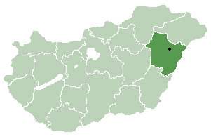
| Voivodeship | Kuyavian-Pomeranian |
| County | Lipno |
| Gmina | Dobrzyń nad Wisłą |
Płomiany [pwɔˈmjanɨ] (German : Plomen) is a village in the administrative district of Gmina Dobrzyń nad Wisłą, within Lipno County, Kuyavian-Pomeranian Voivodeship, in north-central Poland. [1]

German is a West Germanic language that is mainly spoken in Central Europe. It is the most widely spoken and official or co-official language in Germany, Austria, Switzerland, South Tyrol (Italy), the German-speaking Community of Belgium, and Liechtenstein. It is also one of the three official languages of Luxembourg and a co-official language in the Opole Voivodeship in Poland. The languages which are most similar to German are the other members of the West Germanic language branch: Afrikaans, Dutch, English, the Frisian languages, Low German/Low Saxon, Luxembourgish, and Yiddish. There are also strong similarities in vocabulary with Danish, Norwegian and Swedish, although those belong to the North Germanic group. German is the second most widely spoken Germanic language, after English.
Gmina Dobrzyń nad Wisłą is an urban-rural gmina in Lipno County, Kuyavian-Pomeranian Voivodeship, in north-central Poland. Its seat is the town of Dobrzyń nad Wisłą, which lies approximately 26 kilometres (16 mi) south-east of Lipno and 65 km (40 mi) south-east of Toruń.

Lipno County is a unit of territorial administration and local government (powiat) in Kuyavian-Pomeranian Voivodeship, north-central Poland. It was formed on January 1, 1999, as a result of the Polish local government reforms passed in 1998. Its administrative seat and largest town is Lipno, which lies 43 km (27 mi) south-east of Toruń and 84 km (52 mi) east of Bydgoszcz. The county also contains the towns of Skępe, lying 13 km (8 mi) east of Lipno, and Dobrzyń nad Wisłą, 26 km (16 mi) south-east of Lipno.