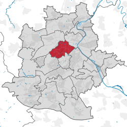
Charlottenburg is a locality of Berlin within the borough of Charlottenburg-Wilmersdorf. Established as a town in 1705 and named after Sophia Charlotte of Hanover, Queen consort of Prussia, it is best known for Charlottenburg Palace, the largest surviving royal palace in Berlin, and the adjacent museums.

St. Pauli is a quarter of the city of Hamburg belonging to the centrally located Hamburg-Mitte borough. Situated on the right bank of the Elbe river, the nearby Landungsbrücken is a northern part of the port of Hamburg. St. Pauli contains a world-famous red-light district around the iconic Reeperbahn area. As of 2020 the area had 21,902 residents.
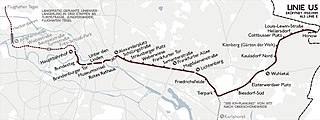
U5 is a line on the Berlin U-Bahn. It runs from Hauptbahnhof in Mitte eastwards through Alexanderplatz, Friedrichshain, Lichtenberg and Friedrichsfelde, surfaces in Biesdorf-Süd to pass Kaulsdorf and Hellersdorf above ground and finally reaches city limits at Hönow.
The U7 is a rail line on the Berlin U-Bahn. It runs completely underground for a length of 31.8 kilometres (19.8 mi) through 40 stations and connects Spandau, via Neukölln, to Gropiusstadt and Rudow. The line was originally the south-eastern branch of the Nord-Süd-Bahn (U6) that ran between the branching point at Belle-Alliance-Straße (Mehringdamm) and Grenzallee; however, in the 1960s, this stretch was separated from the rest of the line and extended at each end to form a new line. As of 2007, the U7 is Berlin's longest underground line, both in terms of absolute length and total travel time, and one of the longest (entire) subterranean lines in Europe.

Friedrichshain is a quarter (Ortsteil) of the borough of Friedrichshain-Kreuzberg in Berlin, Germany. From its creation in 1920 until 2001, it was a freestanding city borough. Formerly part of East Berlin, it is adjacent to Mitte, Prenzlauer Berg, Kreuzberg and Lichtenberg.

The Killesbergpark is an urban public park of half a square kilometre in Stuttgart, Germany. It is just north of the state capital, where Killesberg is a quarter of the borough of Stuttgart-Nord (North).

The Innenstadt is the central city district of Frankfurt am Main, Germany. It is part of the Ortsbezirk Innenstadt I. Its western part forms part of Frankfurt's central business district, the Bankenviertel. Germany's most expensive shopping streets and real estate are found within the city district.
Zeilsheim is a quarter of Frankfurt am Main, Germany. It is part of the Ortsbezirk West and is subdivided into the Stadtbezirke Zeilsheim-Ost, Zeilsheim-Süd and Zeilsheim-Nord.

The Nuremberg U-Bahn is a rapid transit system run by Verkehrs-Aktiengesellschaft Nürnberg, which itself is a member of the Verkehrsverbund Großraum Nürnberg. The Nuremberg U-Bahn is Germany's newest metro system, having begun operation in 1972, although the Nuremberg-Fürth route (U1) uses part of the right of way of the Bavarian Ludwig Railway, Germany's first passenger railway opened in 1835. The current network of the U-Bahn is composed of three lines, serving 49 stations, and comprising 38.2 kilometres (23.7 mi) of operational route, making it the shortest of the four metro systems in Germany, behind Berlin, Hamburg and Munich.

The Cologne Stadtbahn is a light rail system in the German city of Cologne, including several surrounding cities of the Cologne Bonn Region. The term Stadtbahn denotes a system that encompasses elements of trams as well as an underground railway network (U-Bahn) and interurban rail, even including three lines that are licensed as heavy rail and used by freight trains as well as Stadtbahn vehicles. Two of these lines connect the Cologne Stadtbahn to the Bonn Stadtbahn. These lines are jointly operated by both cities' transport authorities, resulting in both systems and the lines connecting them sometimes collectively referred to as Stadtbahn Rhein-Sieg.

The Stuttgart Stadtbahn is a light rail system in Stuttgart, Germany. The Stadtbahn began service on 28 September 1985. It is operated by the Stuttgarter Straßenbahnen AG (SSB), which also operates the bus systems in that city. The Stuttgart Stadtbahn is successor system of a tram network (Straßenbahnen) that characterized the urban traffic in Stuttgart for decades.

Am Hart is the northernmost of the three sub-districts of the Munich city district 11 Milbertshofen-Am Hart.

Neukölln, until 1920 an independent city, is an inner-city district of Berlin in the homonymous borough (Bezirk) of Neukölln, including the historic village of Alt-Rixdorf and numerous Gründerzeit apartment blocks. With 166,714 inhabitants (2018) the Ortsteil is the most densely populated of Berlin. It was originally characterized by mostly working-class inhabitants and later a relatively high percentage of immigrants, especially of Turkish and Russian descent, but since the turn of the millennium an influx of students, creatives, and western immigrants has led to gentrification.
Sachsenhausen-Nord and Sachsenhausen-Süd are two quarters of Frankfurt am Main, Germany. The division into a northern and a southern part is mostly for administrative purposes as Sachsenhausen is generally considered a single entity. Both city districts are part of the Ortsbezirk Süd.

The International horticultural exposition 1993 was held at the Baden-Wuerttemberg state capital, Stuttgart, Germany. The IGA was within the past 54 years already the fifth major horticultural show which hosted Stuttgart in the 20th century. Recognised by the Bureau International des Expositions (BIE), the Expo ran from April 23, 1993, to October 17, 1993. Held at Wartenberg and Killesberg parks, the goal was to be visually and functionally integrated with the two challenging terrains, the Wartberg and the Leibfriedsche garden. This was achieved. The long Advised long-term goal to pull a U-shaped green belt around the city, which became a reality. The mascot of the horticultural show called "Flori", a bird with a cowboy hat. Overall, 7.3 million people visited the garden show. Thus the expectations of the city fathers were exceeded, because it had been expected a turnout of 7 million.

Stuttgart Nord station is in the German state of Baden-Württemberg. It consists of a passenger railway station on the Stuttgart S-Bahn and a goods yard.

The Freiburg im Breisgau tramway network is a network of tramways that forms part of the public transport system in Freiburg im Breisgau, a city in the federal state of Baden-Württemberg, Germany. Established in 1901, the network has been operated since its foundation by the company now known as Freiburger Verkehrs, and powered by electricity. The tramway network currently has five lines. The expansion of the tram network since 1980 has served as an example of the "renaissance of the trams" in Germany. As of 2021, 76 trams were available for regular use: 2 of these were high-floored, 36 partial and 36 low-floored. Almost the entirety of the network is located within Freiburg's urban area; only a few metres of the balloon loop at Gundelfinger Straße are located outside the boundary of Gundelfingen to the north of Freiburg. In total, the trams serve 20 out of the 28 districts in Freiburg.

Barmbek-Süd (help·info) is a quarter of Hamburg, Germany, in the borough of Hamburg-Nord. It is located in the east of Hamburg-Nord, approximately five kilometers from Hamburg city center. Barmbek-Süd is a densely built-up area.

The Heilbronn Stadtbahn is a three line tram-train system in city of Heilbronn in the German state of Baden-Württemberg. It is based on the Karlsruhe model and operated jointly by the Albtal-Verkehrs-Gesellschaft (AVG), the Stadtwerke Heilbronn (SWH) and Deutsche Bahn (DB). It operates on normal railways under the Eisenbahn-Bau- und Betriebsordnung and within Heilbronn under the Verordnung über den Bau und Betrieb der Straßenbahnen.
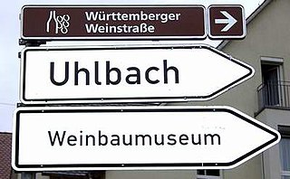
The Württemberger Weinstraße is a Holiday Route through the Wine Growing Area Württemberg that begins in Niederstetten-Oberstetten, via Weikersheim, Heilbronn, Ludwigsburg and Stuttgart to Metzingen. The southern end point of the Württemberger Wine Route is the Kressbronn wine growing exclave on Lake Constance.