
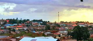
Trans-Nzoia County is a county in the former Rift Valley Province, Kenya, located between the Nzoia River and Mount Elgon, 380 km northwest of Nairobi. At its centre is the town of Kitale which is the county capital and largest town. It is bordered by the Republic of Uganda to the west, Bungoma and Kakamega Counties to the south, West Pokot County to the east, and Elgeyo Marakwet and Uasin Gishu Counties to the southeast. Trans Nzoia covers an area of 2495.5 square kilometres. The county has a cool and temperate climate, with daytime temperatures ranging from 23.4°C to 29.2°C and nighttime temperatures from 11.0°C to 13.5°C. It receives moderate rainfall, making it suitable for agriculture

Moroto District is a district in the Northern Region of Uganda. The town of Moroto is the site of the district headquarters.

Kapchorwa District is a district in the Eastern Region of Uganda. The town of Kapchorwa is the district's main municipal, administrative, and commercial center, and is the site of the district headquarters. It is also the home district of Stephen Kiprotich, the men's marathon gold medalist at the 2012 Summer Olympics, and Joshua Cheptegei, the men's 5,000 m gold medalist at the 2021 Summer Olympics in Tokyo.
Kapchorwa is a town in the Eastern Region of Uganda. It is the main municipal, commercial, and administrative center of Kapchorwa District. Initially, the town of Kapchorwa was known as the Sebei Region.

Bukwo is a town in Eastern Uganda. It is the main municipal, administrative and commercial center of Bukwo District and the headquarters of the district are located there. The district is named after the town.
Bukwo District is a district in the Eastern Region of Uganda. The town of Bukwo is its main political, administrative, and commercial center and the site of the district headquarters.

Kween District is a district in Eastern Uganda. The district headquarters are located at Binyiny, one of the two town councils in the district.
Lwakhakha is a town in the Eastern Region of Uganda. It is one of the municipal centers in Manafwa District. The town lies across the international border from Lwakhakha, Kenya.
The Kapchorwa–Suam Road, is a rural road in the Eastern Region of Uganda. The road links Kapchorwa, the district capital of Kapchorwa District to Suam, at the international border with Kenya.
Suam, Kenya is a settlement in the Trans-Nzoia County of Kenya. It sits across the Suam River from Suam, Uganda, at the international border between the two countries.
Muyembe is a town in the Eastern Region of Uganda.
The Suam–Endebess–Kitale–Eldoret Road, is a rural road in Kenya. The road links Suam, in Trans-Nzoia County, to the towns of Endebess, Kitale, and Eldoret in Uasin Gishu County.
The Kisumu–Kakamega–Webuye–Kitale Road, is a rural road in Kenya. The road links Kisumu, in Kisumu County, to the towns of Kakamega, in Kakamega County, Webuye in Bungoma County, and Kitale in Trans-Nzoia County.
Bukwo General Hospital, also Bukwo District Hospital or Bukwo Hospital, is a hospital in the Eastern Region of Uganda.
Letshego Microfinance Uganda,, whose official name is Letshego Uganda Limited, is a Tier IV microfinance institution in Uganda.
The Nairobi–Malaba Road, also Nairobi–Uganda Road or A104 Road (Kenya) is a major highway in Kenya, the largest economy in the East African Community. The road connects Nairobi, the capital and largest city in Kenya, with the border town of Malaba at the international border with Uganda.
Namisindwa District is a district in the Eastern Region of Uganda. The town of Bupoto is the district headquarters.
Kwanza is a town in Trans-Nzoia County in western Kenya, close to the international border with Uganda. It is the headquarters of Kwanza Ward, one of the constituent wards in Kwanza Constituency.
The Kakira–Kisumu Expressway, also Kenya–Uganda Highway, is a road in Uganda and Kenya, connecting the cities of Kakira and Iganga in Uganda to Busia, Malaba and Kisumu in Kenya.
