Hmar is an Kuki ethnic group living in Northeast Indian state of Manipur, Mizoram, Assam and western Myanmar (Burma) and eastern Bangladesh. They use Meitei language as their second language (L2) in Manipur. They speak Mizo language as their L1 in Mizoram.

Moirang is a town in the Indian state of Manipur, best known for the tentatively listed UNESCO World Heritage Sites of the Keibul Lamjao Conservation Area (KLCA), covering Keibul Lamjao National Park (KLNP), the world's only floating national park, the buffer of Loktak Lake and Pumlen Pat. It is best known for the being the place of origin of the ancient epic legend of Khamba and Thoibi, one of the seven epic cycles of incarnations of Meitei mythology and folklore. Nationwide, it is also famous for the INA War Museum in the INA Martyrs' Memorial Complex, where Colonel Shaukat Malik of the Indian National Army hoisted the Tricolour for the first time on Indian soil on 14 April 1944. It is situated approximately 45 km (28 mi) south of the state capital Imphal. It has an area of 269 km2 (104 sq mi) with a population of 62,187 in 67 villages. There are 12 Panchayats in this block.
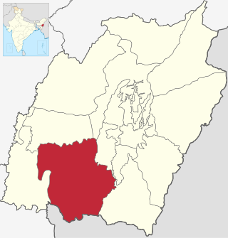
Churachandpur District, is one of the 16 districts of the Indian state of Manipur populated mainly by Kuki-Zomi people. The name honours former Maharaja Churachand Singh of Manipur. The district headquarters is located in the town of Churachandpur, which is also locally known by the name Lamka.
The Paite people are an ethnic group in Northeast India, mainly living in Manipur and Mizoram. The Paites are recognized as a schedule tribe in these two states. They are not regarded as part of the Kuki group, but may be considered part of the wider "Lushai" or Zomi group. "Guite" is a major clan of the Paite people.

Firozabad district forms one of the western districts of the Indian state of Uttar Pradesh, which has Firozabad city as its district headquarters. The district is a part of the Agra division.

Kalaburagi district, formerly known as Gulbarga district, is one of the 31 districts of Karnataka state in southern India. Kalaburagi city is the administrative headquarters of the district. The district is the headquarters of Kalaburagi division.
Kota District is a district of the state of Rajasthan in western India. The city of Kota is the administrative headquarters of the district.

Thoubal district is one of the sixteen districts of Manipur state in northeastern India. This district is bounded by Senapati district on the north, Ukhrul and Chandel districts on the east, Churchandpur and Bishnupur districts on the south and Imphal West and Imphal East districts on the west. The district occupies an area of 324 km2. The population as of 2011 is 286,687. Thoubal town is the district headquarters. This district is known for Khongjom, where the last battle of the independence of Manipur was fought in April 1891 against the British army.

Ukhrul district is an administrative district of the state of Manipur in India with its headquarters at Ukhrul. The Ukhrul district has a long history dating back to the 1920s when it was created as the North-East Hill Sub-Division of the then princely state of Manipur. In 2016, the Kamjong subdivision of the Ukhrul district was spun out as a separate district, leading to the present configuration of the Ukhrul district.
Uniara is a town and a municipality in Tonk district in the Indian state of Rajasthan. It is a tehsil of the Tonk district.

Dhamtari is a district of the Indian state of Chhattisgarh. This district is situated at 20°42' N latitude and 81°33' E longitude. Dhamtari district was officially formed on 6 July 1998 by trifurcating Raipur district into Raipur, Dhamtari and Mahasamund districts.

Singngat is one of the sub-divisional headquarters of Churachandpur district in the Indian state of Manipur and is a key administrative centre in the southwestern border of the state. The Manipur Government officially recorded the name as Singhat, that's because the Meiteis find it difficult to pronounce the original name.
Hiangzou is a ward within Churachandpur town in Manipur, India. Situated on the bank of the Khuga (Tuitha) river, this residential settlement developed from paddy fields. Its first settler, Upa P. Tuahchinhau, moved to Hiangzou on 31 January 1999. More settlers joined within a couple of years.
Hiangtam is a village located within Churachandpur district of Manipur, India.
Guite is the progenitor clan of Zomi people. He is also said to be the Older Brother of Thadou progenitor of the Thadou people. Mostly the Guite clan speak Paite language. Some known as Zomi and few also as Kuki in India and as Chin in Myanmar (Burma). Depending on local pronunciation, the clan was also called differently such as Nguite, Vuite, and was also recorded even as Gwete, Gwite, Nwite. In accord with the claim of their solar origin, the Guite clan has been called nampi, meaning noble or major or even dominant people, of the region in local dialect in the past.

The Zomi Revolutionary Army is an armed Zomi nationalist insurgent group formed in 1997, following an increase in ethnic tensions between the Kuki people and the Paites tribe in Churachandpur district of Manipur, India. Its parent organisation, the Zomi Revolutionary Organisation, was founded in April 1993. Pu K Guite, a Zomi leader from Karbi Anglong, is the founder president of the organisation. It is one of the most powerful group operations in Manipur and in Chin state of Myanmar(Burma).
Sumchinvum is a small village in Singngat, Churachandpur District, Manipur, India. It was also known as 'Dimmual' by the Tedim people inhibiting in the village before the Kuki–Paite ethnic clash of 1997–98.
The Anāl is a Naga tribe native to Manipur state in North-East India and part of Myanmar. They are listed as a Scheduled Tribe, in accordance with The Scheduled Castes and Scheduled Tribes Orders (Amendment) Act, 1976 Indian Constitution. The Anāl tribe is one of the 'sixty six Naga tribes' of the Naga ancestral homeland. The members of this tribe are found both in India and Myanmar. In India, they are situated in the States of Manipur and Nagaland but mostly concentrated in the former. In the State of Manipur, the Anāl Naga population concentrated in Chandel and a few Anāl villages are located in its neighbouring districts, Churachandpur district has about three villages and Thoubal district has one or two.
Rengkai is the most populated and one of the three census towns of Churachandpur District.
Bungmual is a village in a Churachandpur district of Manipur, India. It is further sub-divided into "Veng", some of them are Lamlian Veng, Lai Veng, Hausa Veng, New Lane, Colony Veng, Siloam Veng and Zoar Veng,

