
The counties of Ireland are historic administrative divisions of the island, now used in various contexts. They began as Norman structures, and as the powers exercised by the Cambro-Norman barons and the Old English nobility waned over time, new offices of political control came to be established at a county level.

A county is a geographic region of a country used for administrative or other purposes in certain modern nations. The term is derived from the Old French comté denoting a jurisdiction under the sovereignty of a count (earl) or a viscount. Literal equivalents in other languages, derived from the equivalent of "count", are now seldom used officially, including comté, contea, contado, comtat, condado, Grafschaft, graafschap, and zhupa in Slavic languages; terms equivalent to commune/community are now often instead used.
A county seat is an administrative center, seat of government, or capital city of a county or civil parish. The term is used in Canada, China, Hungary, Romania, Taiwan, and the United States. The equivalent term shire town is used in the U.S. state of Vermont and in some other English-speaking jurisdictions. County towns have a similar function in the Republic of Ireland and the United Kingdom, as well as historically in Jamaica.

Local government is a generic term for the lowest tiers of public administration within a particular sovereign state. This particular usage of the word government refers specifically to a level of administration that is both geographically-localised and has limited powers. While in some countries, "government" is normally reserved purely for a national administration (government), the term local government is always used specifically in contrast to national government – as well as, in many cases, the activities of sub-national, first-level administrative divisions. Local governments generally act only within powers specifically delegated to them by law and/or directives of a higher level of government. In federal states, local government generally comprises a third or fourth tier of government, whereas in unitary states, local government usually occupies the second or third tier of government.

The historic counties of England are areas that were established for administration by the Normans, in many cases based on earlier kingdoms and shires created by the Angles, Saxons, Jutes, Celts and others. They are alternatively known as ancient counties, traditional counties, former counties or simply as counties. In the centuries that followed their establishment, as well as their administrative function, the counties also helped define local culture and identity. This role continued even after the counties ceased to be used for administration after the creation of administrative counties in 1889, which were themselves amended by further local government reforms in the years following.

An unincorporated area is a region that is not governed by a local municipal corporation. Widespread unincorporated communities and areas are a distinguishing feature of the United States and Canada. Most other countries of the world have either no unincorporated areas at all or these are very rare; typically remote, outlying, sparsely populated or uninhabited areas.
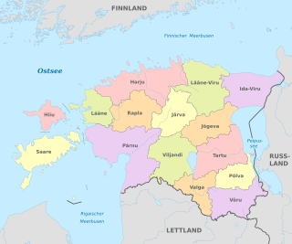
Counties are the first-level administrative subdivisions of Estonia. Estonian territory is composed of 15 counties, including 13 on the mainland and 2 on islands. The government of each county is led by a maavanem (governor) who represents the national government at the regional level. Governors are appointed by the national government for a term of five years.
The counties of England are areas used for different purposes, which include administrative, geographical, cultural and political demarcation. The term "county" is defined in several ways and can apply to similar or the same areas used by each of these demarcation structures. These different types of county each have a more formal name but are commonly referred to just as "counties". The current arrangement is the result of incremental reform.

For local government purposes, Scotland is divided into 32 areas designated as "council areas", which are all governed by single-tier authorities designated as "councils". They have the option under the Local Government (Scotland) Act 1997 of being known as a "comhairle" when opting for a Gaelic name; only Comhairle nan Eilean Siar has chosen this option, whereas the Highland Council has adopted its Gaelic form alongside its English equivalent informally.

The territory of Lithuania is divided into 10 counties, all named after their capitals. The counties are divided into 60 municipalities : 9 city municipalities, 43 district municipalities and 8 municipalities. Each municipality is then divided into elderates. This division was created in 1994 and slightly modified in 2000.
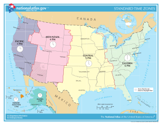
Time in the United States, by law, is divided into nine standard time zones covering the states, territories and other US possessions, with most of the United States observing daylight saving time (DST) for approximately the spring, summer, and fall months. The time zone boundaries and DST observance are regulated by the Department of Transportation, but no single map of those existed until the agency announced intentions to make one in September 2022. Official and highly precise timekeeping services (clocks) are provided by two federal agencies: the National Institute of Standards and Technology (NIST) ; and the United States Naval Observatory (USNO). The clocks run by these services are kept synchronized with each other as well as with those of other international timekeeping organizations.

Non-metropolitan districts, or colloquially "shire districts", are a type of local government district in England. As created, they are sub-divisions of non-metropolitan counties in a two-tier arrangement. Non-metropolitan districts with borough status are known as boroughs, able to appoint a mayor and refer to itself as a borough council.
The counties of the United Kingdom are subnational divisions of the United Kingdom, used for the purposes of administrative, geographical and political demarcation. The older term, shire is historically equivalent to county. By the Middle Ages, county had become established as the unit of local government, at least in England. By the early 17th century, all of England, Wales, Scotland, and Ireland had been separated into counties. In Scotland shire was the only term used until after the Act of Union 1707.
The wards and electoral divisions in the United Kingdom are electoral districts at sub-national level, represented by one or more councillors. The ward is the primary unit of English electoral geography for civil parishes and borough and district councils, the electoral ward is the unit used by Welsh principal councils, while the electoral division is the unit used by English county councils and some unitary authorities. Each ward/division has an average electorate of about 5,500 people, but ward population counts can vary substantially. As of 2021 there are 8,694 electoral wards/divisions in the UK.
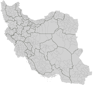
The counties of Iran, called shahrestan, are administrative divisions of larger provinces (ostan). The word shahrestan comes from the Persian words šahr and stân. "County", therefore, is a near equivalent to shahrestan.

Lands administrative divisions of Australia are the cadastral divisions of Australia for the purposes of identification of land to ensure security of land ownership. Most states term these divisions as counties, parishes, hundreds, and other terms. The eastern states of Queensland, New South Wales, Victoria, and Tasmania were divided into counties and parishes in the 19th century, although the Tasmanian counties were renamed land districts in the 20th century. Parts of South Australia (south-east) and Western Australia (south-west) were similarly divided into counties, and there were also five counties in a small part of the Northern Territory. However South Australia has subdivisions of hundreds instead of parishes, along with the Northern Territory, which was part of South Australia when the hundreds were proclaimed. There were also formerly hundreds in Tasmania. There have been at least 600 counties, 544 hundreds and at least 15,692 parishes in Australia, but there are none of these units for most of the sparsely inhabited central and western parts of the country.
