Subligna, Georgia

Last updated
Subligna
Sawmill in Subligna, Georgia (circa 1900).jpg
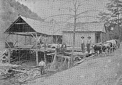
Sawmill in Subligna, circa 1900
USA Georgia location map.svg
Red pog.svg
Subligna
Location in Georgia
Usa edcp location map.svg
Red pog.svg
Subligna
Location in the United States
Coordinates: 34°33′36″N85°11′15″W / 34.56000°N 85.18750°W / 34.56000; -85.18750 Coordinates: 34°33′36″N85°11′15″W / 34.56000°N 85.18750°W / 34.56000; -85.18750
CountryUnited States
State Georgia
County Chattooga
Settledc. 1848
Incorporated1870
Disestablished1995

Subligna is an unincorporated community in Chattooga County, Georgia, United States. [1]

History

A post office was established at Subligna in 1848, and remained in operation until it was discontinued in 1953. [2] The name honors a settler named Dr. William Dunlap Underwood, subligna being a Latin construct meaning "under wood". [3]

The Georgia General Assembly incorporated Subligna as a town in 1870. [4] The town's municipal charter was repealed in 1995. [5]

Related Research Articles

Chattooga County, Georgia County in Georgia, United States

Chattooga County is a county located in the northwestern part of the U.S. state of Georgia. As of the 2010 census, the population was 26,015. According to the World Population Review, as of 2021, it is estimated at 24,803. The county seat is Summerville. The county was created on December 28, 1838.

Lyerly, Georgia Town in Georgia, United States

Lyerly is a town in Chattooga County, Georgia, United States. As of the 2020 census, the town had a population of 454.

Menlo, Georgia City in Georgia, United States

Menlo is a small city in Chattooga County, Georgia, United States. The population was 474 at the 2010 census.

Summerville, Georgia City in Georgia, United States

Summerville is a city and the county seat of Chattooga County, Georgia, United States. The population was 4,534 at the 2010 census.

Chattooga River River in the Southeastern USA

The Chattooga River is the main tributary of the Tugaloo River.

Chattahoochee–Oconee National Forest

The Chattahoochee–Oconee National Forest in northern Georgia comprises two United States National Forests, the Oconee National Forest in eastern Georgia and the Chattahoochee National Forest located in the North Georgia Mountains. The Chattahoochee National Forest is composed of an eastern and western forest. The western forest contains Johns Mountain, Little Sand Mountain, and Taylor Ridge (Georgia). The combined total area of the Chattahoochee–Oconee National Forest is 866,468 acres (3,506 km2), of which the Chattahoochee National Forest comprises 750,145 acres (3,036 km2) and the Oconee National Forest comprises 116,232 acres (470 km2). The county with the largest portion of the eastern forest is Rabun County, Georgia, which has 148,684 acres (601.7 km2) within its boundaries.

Trion, Georgia Town in Georgia, United States

Trion is a town in Chattooga County, Georgia, United States. The population was 1,827 as of the 2010 census, down from 1,993 at the 2000 census. Trion is the second-largest incorporated community in Chattooga County, which has a population of approximately 26,000. Trion is known as the denim capital of the world because of the Mount Vernon manufacturing plant, which employs about 4,000 people.

Andrew Perry Allgood (1816–1882) was a mill owner in Georgia.

Taylor Ridge (Georgia)

Taylor Ridge is the most northwestern ridge in the state of Georgia within the Ridge and Valley physiographic region and is approximately 40 miles (64 km) in length. To the west the ridge is bordered by the Cumberland Plateau region and to the north Taylor Ridge becomes White Oak Mountain at Ringgold Gap although technically part of the same ridge. The western foothills of Taylor Ridge are also the western border of the Chattahoochee National Forest. Taylor Ridge is part of the Armuchee Ridges which also consist of Little Sand Mountain, Dicks Ridge, Johns Ridge, Horn Mountain and Rocky Face. Taylor Ridge runs south to north through Chattooga, Walker, Whitfield, and Catoosa counties along the towns of Summerville, Trion, Lafayette and Ringgold. The highpoint of the ridge is 1,665 feet (507 m) where the ridge buckles with Dicks Ridge. An area labeled high point is 1,432 feet (436 m) at the ridges southern terminus along GA highway 100.

Cloudland, Georgia Unincorporated community in Georgia, United States

Cloudland is an unincorporated community in western Chattooga County in the U.S. state of Georgia. It is located at an elevation of 1,498 feet atop Lookout Mountain, a broad ridge that occupies northwestern Georgia and northeastern Alabama. The Girl Scouts' Camp Juliette Low, named for founder Juliette Gordon Low, is located just northeast of town.

Berryton is an unincorporated community in Chattooga County, in the U.S. state of Georgia.

Chattoogaville is an unincorporated community in Chattooga County, in the U.S. state of Georgia. The community lies about 12 miles (19 km) south of the county seat at Summerville.

Chelsea is an unincorporated community in Chattooga County, in the U.S. state of Georgia.

Farmersville is an unincorporated community in Chattooga County, in the U.S. state of Georgia.

Gore is an unincorporated community in Chattooga County, in the U.S. state of Georgia.

Holland is an unincorporated community in Chattooga County, in the U.S. state of Georgia.

Pennville is an unincorporated community in Chattooga County, in the U.S. state of Georgia.

Shackelton is a ghost town in Chattooga County, in the U.S. state of Georgia.

Silver Hill is an unincorporated community in Chattooga County, in the U.S. state of Georgia.

Van Wert is an unincorporated community in Polk County, in the U.S. state of Georgia.

References

  1. U.S. Geological Survey Geographic Names Information System: Subligna, Georgia
  2. "Chattooga County". Jim Forte Postal History. Retrieved 25 April 2015.
  3. "Subligna". Calhoun Times. September 1, 2004. p. 37. Retrieved 24 April 2015.
  4. Acts Passed by the General Assembly of Georgia. J. Johnston. 1870. p. 175.
  5. Krakow, Kenneth K. (1975). Georgia Place-Names: Their History and Origins (PDF). Macon, GA: Winship Press. p. 214. ISBN   0-915430-00-2.