
Gwinnett County is a suburban county of Atlanta in the north central portion of the U.S. state of Georgia. In 2020, the population was 957,062, making it the second-most populous county in Georgia. Its county seat is Lawrenceville. The county is named for Button Gwinnett, one of the signatories of the Declaration of Independence.

Duluth is a city in Gwinnett County, Georgia, United States. Located north of Interstate 85, it is approximately 22 miles (35 km) northeast of Atlanta.

Suwanee is a city in Gwinnett County in the U.S. state of Georgia. As of the 2010 census, the population was 15,355; this had grown to an estimated 20,907 as of 2019.

Gwinnett County Transit or GCT is the bus public transit system in Gwinnett County, Georgia, United States, one of metro Atlanta's three most populous suburban counties.
Stone Mountain Freeway is a freeway in the north-central part of the U.S. state of Georgia. It connects Interstate 285 (I-285) east of Atlanta, with the suburbs of Stone Mountain and Snellville before transitioning into an arterial road that continues to Athens. The freeway is signed as U.S. Route 78 (US 78) for its entire length, with the western half signed as State Route 410 (SR 410), and the eastern half also being signed as SR 10. It begins at the US 29/US 78 split northeast of Decatur, and continues east through eastern DeKalb and southern Gwinnett counties.

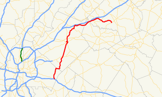
State Route 316 (SR 316), also known as University Parkway, or Georgia 316, is a 38.9-mile-long (62.6 km) state highway that exists in the northern part of the U.S. state of Georgia. It links the Atlanta metropolitan area with Athens, home of the University of Georgia.

State Route 141 (SR 141) is a 34.1-mile-long (54.9 km) state highway that runs southwest-to-northeast in the northwest part of the U.S. state of Georgia. It connects the Buckhead area of Atlanta with Cumming. Its routing exists within portions of Fulton, DeKalb, Gwinnett, Forsyth counties.

State Route 317 is a state highway in the Atlanta metropolitan area of the U.S. state of Georgia.

State Route 13 (SR 13) is a 49.5-mile-long (79.7 km) state highway in the north-central part of the U.S. state of Georgia, that travels through portions of Fulton, DeKalb, Gwinnett, and Hall counties.
Ronald Reagan Parkway (RRP) is a controlled-access highway located in the northeastern part of the Atlanta metropolitan area in the U.S. state of Georgia. Its route is entirely within the south-central portion of Gwinnett County, connecting the Lilburn area with Snellville. It is named after Ronald Reagan, the 40th president. The highway was spearheaded by then-Gwinnett County chairman Wayne Mason in the mid-1990s.

State Route 120 (SR 120) is a 90.7-mile-long (146.0 km) state highway that runs west-to-east through portions of Haralson, Paulding, Cobb, Fulton, and Gwinnett counties in northwestern part of the U.S. state of Georgia.
State Route 124 (SR 124) is a 51.1-mile-long (82.2 km) state highway that runs southwest-to-northeast through portions of DeKalb, Gwinnett, Barrow, and Jackson counties in the north-central part of the U.S. state of Georgia.
State Route 140 (SR 140) is a 78.6-mile-long (126.5 km) state highway in the northwestern part of the U.S. state of Georgia. It connects the Armuchee and Peachtree Corners areas, within portions of Floyd, Bartow, Cherokee, Fulton, Gwinnett counties.
Interstate 85 (I-85) is a major Interstate Highway that travels northeast-to-southwest in the U.S. state of Georgia. It enters the state at the Alabama state line near West Point, and Lanett, Alabama, traveling through the Atlanta metropolitan area and to the South Carolina state line, where it crosses the Savannah River near Lake Hartwell. I-85 connects northern Georgia with Montgomery, Alabama, to the southwest, and with South Carolina, North Carolina, and Virginia to the northeast. Within Georgia, I-85 is also designated as the unsigned State Route 403 (SR 403).

State Route 365 (SR 365) is a 69.5-mile-long (111.8 km) state highway that travels within portions of Gwinnett, Hall, Habersham, and Stephens counties. It begins at exit 113 on Interstate 85 (I-85), at the southeastern edge of Suwanee. This is also the southern terminus of I-985. It continues from that point concurrent with I-985 for the entire length of that freeway. Eventually, U.S. Route 23 (US 23) also joins the concurrency. The highway heads northeast through Gainesville and Toccoa, before it terminates at the South Carolina state line, southwest of Westminster, South Carolina.
The Outer Perimeter is a freeway originally planned to encircle Atlanta, in the U.S. state of Georgia about 20 to 25 miles outside of Interstate 285, which is colloquially referred to as the Perimeter and is a point of reference for local travel outside Atlanta's city core.

State Route 324 (SR 324) is a 9.6-mile-long (15.4 km) west-to-east state highway located in portions of Gwinnett and Barrow counties in the northeastern part of the U.S. state of Georgia. It connects Buford and Auburn. It also has an interchange with Interstate 85 (I-85). Before it was renamed, Carl Bethlehem Road was once part of SR 324.
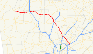
U.S. Route 78 (US 78) is a 233.3-mile-long (375.5 km) U.S. Highway in the U.S. state of Georgia. It travels west to east in the north-central part of the state, starting at the Alabama state line, west of Tallapoosa, where the roadway continues concurrent with the unsigned highway Alabama State Route 4. This is also the western terminus of Georgia State Route 8 (SR 8), which is concurrent with US 78 to the east. The highway serves the Atlanta, Athens, and Augusta metropolitan areas on its path from the Alabama state line to the South Carolina state line, at the Savannah River, on the northeastern edge of Augusta, where it continues concurrent with US 1/US 25/US 278/SC 121. This is also the eastern terminus of SR 10. US 78 travels through portions of Haralson, Carroll, Douglas, Cobb, Fulton, DeKalb, Gwinnett, Walton, Oconee, Clarke, Oglethorpe, Wilkes, McDuffie, Columbia, and Richmond counties.
There were several historic bridges around the metro Atlanta, Georgia area, for which many of its current-day roads are named. Many of them originated as ferries, dating back to the 1820s and 1830s, and carrying travelers across the Chattahoochee River and several other smaller rivers. Several were also covered bridges, very few of which remain as historic sites.

The Gwinnett Place Transit Center is a regional bus station and a major stop for Gwinnett County Transit buses in Gwinnett County and Atlanta, Georgia. The terminal contains a seating area, and is in close proximity to the Gwinnett Place & Sugarloaf business districts.

