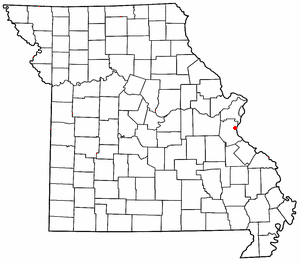
Sulphur Springs is an unincorporated community in eastern Jefferson County, Missouri, United States. It is located near Barnhart, bordering the banks of Glaize Creek and the Mississippi River.

Belknap Springs is an unincorporated community and private hot springs resort in Lane County, Oregon, United States, near the McKenzie River. The springs were located and initially developed by R. S. Belknap in 1869. A post office named "Salt Springs" was established in the location in 1874, and the name changed to "Belknap Springs" in 1875. The post office closed in 1877 and reopened in 1891, operating intermittently until 1953. Today the location uses a McKenzie Bridge mailing address.

Sulphur Springs is a census-designated place (CDP) in eastern Liberty Township, Crawford County, Ohio, United States. As of the 2010 census it had a population of 194. It has a post office with the ZIP code 44881. It is located along State Route 98 northeast of the city of Bucyrus, the county seat of Crawford County.
Green Sulphur Springs is an unincorporated community in Summers County, West Virginia, United States. It lies near Interstate 64 to the northeast of the city of Hinton, the county seat of Summers County. Its elevation is 1,552 feet. Green Sulphur Springs had a post office, with the ZIP code of 25966, until it closed on February 29, 1992.
London Springs is an unincorporated community in Lane County, Oregon, United States. It lies 11.33 miles (18.23 km) south-southwest of Cottage Grove at an elevation of 896 feet (273 m). London Springs is near the Coast Fork Willamette River, south of Cottage Grove Lake.
Tenmile is an unincorporated community in Douglas County, Oregon, United States. It is located on Oregon Route 42 southwest of Roseburg.
Orrs Springs is a set of springs around which grew a resort and a stagecoach station in Mendocino County, California. It is located 15 miles (24 km) almost directly north of Boonville, at an elevation of 1001 feet. However, it is accessible from Ukiah by following Orr Springs Rd.
Vichy Springs is a set of springs around which formed a resort in Mendocino County, California, United States. It is located on Sulphur Creek 3 miles (4.8 km) east-northeast of Ukiah, at an elevation of 801 feet.

Brashear is an unincorporated community located on Interstate Highway 30 and Farm to Market Road 2653 in west central Hopkins County, Texas, United States. Brashear has a post office, church, farm buildings, a radio building, and other buildings.
Cold Springs is an unincorporated community in Umatilla County, Oregon, United States, south of the Columbia River in the Hermiston area. Cold Springs Junction is a populated place and highway junction about 4 miles (6 km) northeast of Cold Springs at the junction of Oregon Route 37 and U.S. Route 730.

Dolph is an unincorporated community in Tillamook County, Oregon, United States, near the Yamhill County line. It lies at the junction of Oregon Route 22 and Oregon Route 130 between Grande Ronde and Hebo, on the Little Nestucca River. It is within the Siuslaw National Forest in the Northern Oregon Coast Range.
Sulphur, Nevada, is a ghost town in Humboldt County, Nevada that was a Feather River Route station in the Black Rock Desert along the Kamma Mountains.
Sulphur City is an unincorporated community in White River Township, Washington County, Arkansas, United States. It is located at the intersection of Black Oak Road and Whitehouse Road (CR 43). The community is on the east bank of the Middle Fork of the White River. The community of Black Oak lies approximately 1.5 miles to the northwest on the opposite side of the river.
Sulphur Springs is an unincorporated community in DeKalb County, in the U.S. state of Alabama.
White Sulphur Springs is an unincorporated community in Marion Township, Pike County, in the U.S. state of Indiana.

White Sulphur is an unincorporated community in Delaware County, in the U.S. state of Ohio.
Royal Oak is an unincorporated community in Oregon County, in the U.S. state of Missouri. The community is located on U.S. Route 160, approximately five miles northwest of Alton. Dry Creek flows past approximately one half mile east of the location.
Sulphur Spring is an unincorporated community in Center Township, Rush County, in the U.S. state of Indiana.
White Sulphur Springs is an unincorporated community in Meriwether County, in the U.S. state of Georgia.

Mineral Hill is a ghost town in Eureka County, Nevada, US.

