Related Research Articles

Abbotsford is a city located in British Columbia, adjacent to the Canada–United States border, Greater Vancouver and the Fraser River. With an estimated population of 141,397 people it is the largest municipality in the province outside Metro Vancouver. Abbotsford-Mission has the third highest proportion of visible minorities among census metropolitan areas in Canada, after the Greater Toronto Area and the Greater Vancouver CMA. It is home to Tradex, the University of the Fraser Valley, and Abbotsford International Airport.

The Township of Langley is a district municipality immediately east of the City of Surrey in southwestern British Columbia, Canada. It extends south from the Fraser River to the U.S. border, and west of the City of Abbotsford. Langley Township is not to be confused with the City of Langley, which is adjacent to the township but politically is a separate entity. Langley is located in the eastern part of Metro Vancouver.
Abbotsford is a federal electoral district in British Columbia, Canada, that has been represented in the House of Commons of Canada since 2004.
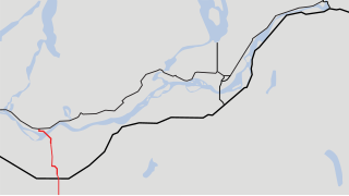
Highway 11, known locally as the Abbotsford-Mission Highway, is a 17 km (11 mi) long at-grade expressway that figuratively cuts the Fraser Valley in half. The highway was first given the '11' designation in 1958, and it originally followed South Fraser Way through Abbotsford, being re-routed onto the four-lane Sumas Way in the mid-1980s. Highway 11 originally entered Mission over the same bridge that carries a spur of the Canadian Pacific Railway across the Fraser River, but it was re-routed onto its own bridge, the Mission Bridge, in 1973.

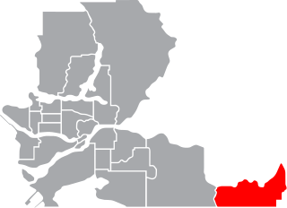
The Fraser Valley Regional District (FVRD) is a regional district in British Columbia, Canada. Its headquarters are in the city of Chilliwack. The FVRD covers an area of 13,361.74 km² (5,159 sq mi). It was created in 1995 by an amalgamation of the Fraser-Cheam Regional District and Central Fraser Valley Regional District and the portion of the Dewdney-Alouette Regional District from and including the District of Mission eastwards.

Yarrow is a small community located 90 kilometres east of Vancouver within the City of Chilliwack in British Columbia, Canada. It is in the Fraser Valley at the foot of Vedder Mountain. The village was first settled by Mennonites in the late 1920s, following the draining of Sumas Lake and the reclamation of the former lake bed for agriculture.
Clearbrook is a neighbourhood of the City of Abbotsford, British Columbia, located in the western portion of the city in the vicinity of Clearbrook Road. The area was originally known as Sandy Flats or West Abbotsford, and was located in the Poplar district of the District of Matsqui. It became known as Clearbrook by the late 1940s, most likely named after Clearbrook Road, a road that originally ran from Old Yale Road south across the Canada-USA border to nearby Clearbrook, Washington.
Huntingdon is a community within Abbotsford, British Columbia, Canada. It is located immediately north of the Canada–US border, and is the location of the Sumas-Huntingdon Border Crossing. The main road through the community is Highway 11. The name of the community is also the present name of the border crossing connecting to Sumas, Washington.
Mount Lehman or Mt. Lehman is a small rural community located in the Fraser Valley of south western British Columbia, Canada. The community was established in 1874 and became part of the District of Matsqui in 1892. The District of Matsqui was incorporated into the present day City of Abbotsford, British Columbia in 1995.

Sumas Mountain, also referred to as Canadian Sumas to distinguish it from an identically-named mountain just 10 km (6.2 mi) to the south in U.S. state of Washington across the border, is a mountain in eastern Fraser Lowland, in the Lower Mainland region of the Canadian province of British Columbia. It sits on the south bank of the Fraser River, west of the smaller Chilliwack Mountain across the Vedder River mouth, and serves as a geographic landmark dividing the Fraser Valley into "Upper" and "Lower" sections.
Nicomen Island is an island in the Fraser River east of Mission and between Deroche (E) and Dewdney (W). Located on the river's north side, and separated from the foot of the Douglas Ranges by Nicomen Slough, the island is near-totally given over to agriculture and constitutes a rural community in its own right, although "downtown Dewdney" is located near its western end and the Indian Reserve of the Lakahahmen First Nation is located about mid-way along its north side.
Bradner is a community within the City of Abbotsford, British Columbia, Canada, located in a rural northwest region of that city which also includes Mount Lehman. Bradner occupies a height of land above the Fraser River, immediately across which is the community of Silverdale, a part of the District of Mission, and Ruskin, on the border between Mission and Maple Ridge. On the floodplain below to the west is the Langley rural neighbourhood of Glen Valley, while on the floodplain to the east, which is called Matsqui Prairie, the nearest Abbotsford neighbourhood is Matsqui Village. Bradner was formerly part of the District of Matsqui, which in 1995 was amalgamated into the City of Abbotsford.
Matsqui Island is a large island in the Fraser River in the Central Fraser Valley region of British Columbia, Canada, located between the City of Abbotsford (S) and the District of Mission (N) and about a mile downstream from the Mission Bridge. Though technically located within the District of Mission, Matsqui Island and adjoining sandbars are part of the Matsqui Indian Reserve and are governed by the Matsqui First Nation.
Matsqui is a former District Municipality in British Columbia, Canada. It was incorporated in 1892, and merged with the District Municipality of Abbotsford in 1995 to create the new City of Abbotsford. Matsqui used to be the west part of what is now Abbotsford. It had commercial growth in the Clearbrook area which then spilled over to Abbotsford.
The Leqʼ a꞉ mel First Nation, formerly known as the Lakahahmen First Nation, is a First Nations band government whose community and offices are located in the area near Deroche, British Columbia, Canada, about 12 kilometres east of the District of Mission. They are a member government of the Sto:lo Nation Chiefs Council, which is one of two tribal councils of the Sto:lo.
The Central Fraser Valley Regional District was a regional district in the province of British Columbia, Canada, located in the Lower Mainland region, south of the Fraser River and west of Chilliwack. It comprised the Township and City of Langley, the Village of Abbotsford, and the Districts of Matsqui and Sumas, plus adjoining unincorporated areas.
Sumas Prairie is a landform in British Columbia, Canada and the State of Washington, United States. Part of the Fraser Lowland, it was created by the draining of Sumas Lake early in the 20th Century, and extends from the Vedder Canal southwestwards into northern Whatcom County, Washington. All of its Canadian portion, except its northeasternmost area around Yarrow, which is part of today's City of Chilliwack, was formerly the District of Sumas, which was amalgamated into the City of Abbotsford in 1972.
The Reach Gallery Museum is a public art gallery and museum located in Abbotsford, British Columbia. It exhibits artwork from across Canada and around the world. The Reach is also the regional archival repository and houses a significant collection of material culture from the Abbotsford region.
The Matsqui people are a Sto:lo Aboriginal group located in the Central Fraser Valley region of British Columbia, Canada. Their band government is the Matsqui First Nation, a member of the Sto:lo Nation tribal council. The core traditional territory of the Matsqui stretches along the Fraser River from Crescent Island to Sumas Mountain, and southward beyond the Canada-United States border. Today the band administers four reserves and has a population of 225.
References
Coordinates: 49°04′00″N122°07′00″W / 49.06667°N 122.11667°W
| | This article about a location on the Coast of British Columbia, Canada is a stub. You can help Wikipedia by expanding it. |