Related Research Articles

The Lower Mainland is a geographic and cultural region of the mainland coast of British Columbia that generally comprises the regional districts of Metro Vancouver and the Fraser Valley. Home to approximately 3.05 million people as of the 2021 Canadian census, the Lower Mainland contains sixteen of the province's 30 most populous municipalities and approximately 60% of the province's total population.
The Fraser Valley is a geographical region in southwestern British Columbia, Canada and northwestern Washington State. It starts just west of Hope in a narrow valley encompassing the Fraser River and ends at the Pacific Ocean stretching from the North Shore Mountains, opposite the city of Vancouver BC, to just south of Bellingham, Washington.

Abbotsford is a city in British Columbia next to the Canada–United States border, Greater Vancouver and the Fraser River. With a census population of 153,569 people (2021), it is the largest municipality in the province outside metropolitan Vancouver. Abbotsford–Mission has the third-highest proportion of visible minorities among census metropolitan areas in Canada, after the Greater Toronto Area and the Greater Vancouver CMA. It is home to Tradex, the University of the Fraser Valley, and Abbotsford International Airport.

Abbotsford is a federal electoral district in British Columbia, Canada, that has been represented in the House of Commons of Canada since 2004.

Langley was a federal electoral district in the province of British Columbia, Canada, that was represented in the House of Commons of Canada from 2004 to 2015. It was a 327 km2 in area with 117,858 people located in the suburbs of the Lower Mainland.
Langley—Abbotsford was a federal electoral district in British Columbia, Canada, that was represented in the House of Commons of Canada from 1997 to 2004.
This is page shows results of Canadian federal elections in the Fraser Valley region of British Columbia. As defined for this article, the Fraser Valley includes the southern suburbs of Vancouver. Areas outside the Fraser Valley, namely the Fraser Canyon and regions to its west, are also included within one of the ridings. The largest of these ridings is the Chilliwack-Hope riding. This riding also includes most of the Fraser Valley until it joins the Okanagan-Similkameen and extends westward until outside Abbotsford.
Aldergrove is a community in the Township of Langley within British Columbia, Canada, approximately 59 km (37 mi) east of Vancouver. The community is urban in nature and, although not incorporated as a town, is often referred to as one. Aldergrove is located at the southeastern edge of both the Township of Langley and the Greater Vancouver metropolitan area, near the western edge of the Abbotsford metropolitan area. It is home to the Lynden–Aldergrove Border Crossing, one of the Lower Mainland's five land border crossings, connecting it with Lynden, Washington.
McMillan Island is an island in the Fraser River, British Columbia, Canada, also known as McMillan Slough..
Huntingdon is a community within Abbotsford, British Columbia, Canada. It is located immediately north of the Canada–US border, and is the location of the Sumas–Huntingdon Border Crossing. The main road through the community is Highway 11. The name of the community is also the present name of the border crossing connecting to Sumas, Washington.
Mount Lehman or Mt. Lehman is a small rural community located in the Fraser Valley of south western British Columbia, Canada. The community was established in 1874 and became part of the District of Matsqui in 1892. The District of Matsqui was incorporated into the present day City of Abbotsford, British Columbia in 1995.
Sumas Mountain, also referred to as Canadian Sumas to distinguish it from an identically named mountain just 10 km (6.2 mi) to the south in U.S. state of Washington across the border, is a mountain in eastern Fraser Lowland, in the Lower Mainland region of the Canadian province of British Columbia. It sits on the south bank of the Fraser River, west of the smaller Chilliwack Mountain across the Vedder River mouth, and serves as a geographic landmark dividing the Fraser Valley into "Upper" and "Lower" sections. Sumas Peak is an official name for the summit located on the south shore of the Fraser River in the Fraser Valley between Abbotsford and Chilliwack, British Columbia. Elevation 910 m (2,986 ft) above sea level, prominence 875 m (2,871 ft).
Bradner is a community within the City of Abbotsford, British Columbia, Canada, located in a rural northwest region of that city which also includes Mount Lehman. Bradner occupies a height of land above the Fraser River, immediately across which is the community of Silverdale, a part of the District of Mission, and Ruskin, on the border between Mission and Maple Ridge. On the floodplain below to the west is the Langley rural neighbourhood of Glen Valley, while on the floodplain to the east, which is called Matsqui Prairie, the nearest Abbotsford neighbourhood is Matsqui Village. Bradner was formerly part of the District of Matsqui, which in 1995 was amalgamated into the City of Abbotsford.
Matsqui Island is a large island in the Fraser River in the Central Fraser Valley region of British Columbia, Canada. It is located north of the City of Abbotsford and south of the City of Mission and about 1.6 kilometres (1 mi) downstream from the Mission Bridge. Though technically located within the District of Mission, Matsqui Island and adjoining sandbars are part of the Matsqui Indian Reserve and are governed by the Matsqui First Nation.
Matsqui is a former district municipality in British Columbia, Canada. It was incorporated in 1892 and merged with the district municipality of Abbotsford in 1995 to create the new City of Abbotsford. Matsqui used to be the western part of what is now Abbotsford. It had commercial growth in the Clearbrook area which then spilled over to Abbotsford.
The Leq'á:mel First Nation, formerly known as Lakahahmen First Nation, is a First Nations band government whose community and offices are located in the area near Deroche, British Columbia in the Fraser Valley region in Canada, about 12 kilometres east of the District of Mission. They are a member government of the Sto:lo Nation Chiefs Council, which is one of two tribal councils of the Sto:lo.
Sumas was a district municipality in the Fraser Valley region of British Columbia, Canada, located between the then-Village of Abbotsford (W) and Chilliwack (E). It was amalgamated with the Village of Abbotsford in 1972 into the District of Abbotsford.
Sumas Prairie is a landform in British Columbia, Canada and the State of Washington, United States. Part of the Fraser Lowland, it was created by the draining of Sumas Lake early in the 20th Century, and extends from the Vedder Canal southwestwards into northern Whatcom County, Washington. The British Columbia Highway 1 traverses the former lakebed on the prairie between Abbotsford and Chilliwack.

Hatzic is a historic community in the Central Fraser Valley region of the Lower Mainland of British Columbia, Canada, located on the east side of the City of Mission and including areas beyond the municipal boundary to the east and northeast.
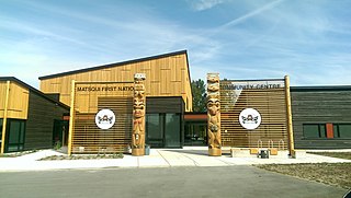
The Matsqui people are a Sto:lo Aboriginal group located in the Central Fraser Valley region of British Columbia, Canada. Their band government is the Matsqui First Nation, a member of the Sto:lo Nation tribal council. The core traditional territory of the Matsqui stretches along the Fraser River from Crescent Island to Sumas Mountain, and southward beyond the Canada-United States border. Today the band administers four reserves and has a population of 225. Their original language is Halq'eméylem.
References
49°05′00″N122°15′00″W / 49.08333°N 122.25000°W
| | This article about a location on the South Coast of British Columbia, Canada is a stub. You can help Wikipedia by expanding it. |