
Kadirli, historically Kars, is a city in Osmaniye Province in the Mediterranean region of Turkey. It is the seat of Kadirli District. Its population is 98,469 (2022). It is located in the Çukurova plain, 41 kilometres from the large city of Osmaniye. It is located near the ancient site of Flaviopolis.

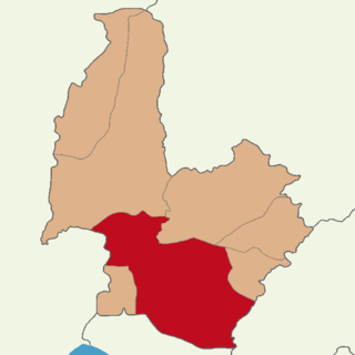
Osmaniye Province is a province in south-central Turkey. It was named Cebel-i Bereket in the early republic until 1933, when it was incorporated into Adana Province. It was made a province again in 1996. It covers an area of 3,767 km2 and has a population of 557,160. The province is situated in Çukurova, a geographical, economical and cultural region. The capital of the province is Osmaniye. Other major towns include Kadirli and Düziçi.

Osmaniye is a city on the eastern edge of the Çukurova plain in southern Turkey. It is the seat of Osmaniye Province and Osmaniye District. Its population is 252,186 (2022).
Altıntaş is a town in Kütahya Province in the Aegean region of Turkey. It is the seat of Altıntaş District. Its population is 5,258 (2022).

Çavdarhisar is a town in Kütahya Province in the Aegean region of Turkey. It is the seat of Çavdarhisar District. Its population is 2,099 (2022). Its elevation is 1,026 m (3,366 ft). The local Kocaçay stream is still crossed by the Roman Penkalas Bridge.
Toprakkale is a town in Osmaniye Province in the Mediterranean region of Turkey. It is the seat of Toprakkale District. Its population is 11,411 (2022). It is located at 10 km to the west of Osmaniye. Its name comes from an Abbasid castle near the city.
Bahçe is a town in Osmaniye Province in the Mediterranean region of Turkey. It is the seat of Bahçe District. Its population is 16,110 (2022). It is located in the Nur Mountains area.
Hasanbeyli is a town in Osmaniye Province in the Mediterranean region of Turkey. It is the seat of Hasanbeyli District. Its population is 2,638 (2022). Near the town stands a badly damaged medieval watchtower that once guarded a strategic route through the Amanus Mountains from Cilicia Pedias to Gaziantep.
Gökçedam is a village in the Osmaniye District in Osmaniye Province, Turkey. Its population is 586 (2022). The village is inhabited by Turkmens. It was the birthplace of the famous Turkish novelist of Kurdish origin Yaşar Kemal.
Yarbaşı is a town (belde) in the Düziçi District, Osmaniye Province, Turkey. Its population is 3,559 (2022). It is on the Osmaniye-Düziçi highway, 5 kilometres (3.1 mi) from central Düziçi and 24 kilometres (15 mi) from the city of Osmaniye.
Ellek is a town (belde) in the Düziçi District, Osmaniye Province, Turkey. Its population is 6,277 (2022). The distance to Düziçi is 15 kilometres (9.3 mi) and to Osmaniye is 30 kilometres (19 mi). Ellek, a former village, was declared a seat of township after being merged with another village in 1968. Main economic activity is peanut agriculture and dairying.
Cevdetiye is a town (belde) in the Osmaniye District, Osmaniye Province, Turkey. Its population is 6,239 (2022). It is 8 kilometres (5.0 mi) north of Osmaniye, on the road connecting Osmaniye to Kadirli at the east end of the Çukurova (Cilicia) plains.
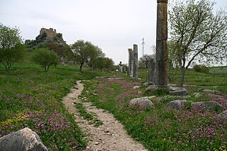
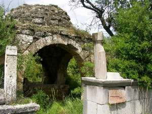
Kırmıtlı is a village in the Osmaniye District of Osmaniye Province, Turkey. Its population is 767 (2022). Before the 2013 reorganisation, it was a town (belde). It lies along Ceyhan River. It is situated at the east end of Çukurova plains. Distance to Osmaniye is 17 kilometres (11 mi). The town is a part of a bird sanctuary known as Castabala valley. There are ruins of the ancient city of Castabala around the town.
Mehmetli is a town (belde) in the Sumbas District, Osmaniye Province, Turkey. Its population is 2,210 (2022). It is at the southeast of Mehmetli Dam reservoir and 5 kilometres (3.1 mi) north of Sumbas. Distance to Osmaniye, the province center, is 65 kilometres (40 mi). The name of the town refers to personal name Mehmet which is very common in the settlement. The settlement was founded in 1835 as a small village of several families. In 1998 it was declared a seat of township.
Atalan is a town (belde) in the Düziçi District, Osmaniye Province, Turkey. Its population is 1,593 (2022). It is situated at the easternmost part of Çukuroca plains, 10 kilometres (6.2 mi) west of Düziçi. Up to 1968 Atalan was a remote neighbourhood of Böcekli a town to the north. In 1968 it was declared a village and in 1998 it was declared a seat of township. Main revenues of the town are pistachio and dairying.
Yarpuz is a village in the Osmaniye District in Osmaniye Province, Turkey. Its population is 794 (2022). It is situated in Nur Mountains and along Yarpuz creek which is actually a tributary of Ceyhan River. The distance to Osmaniye is about 20 kilometres (12 mi). Although presently only a village, Yarpuz was the capital of Cebelibereket sanjak during the last years of the Ottoman Empire.
Osmaniye is a village in the Bayramiç District of Çanakkale Province in Turkey. Its population is 22 (2021).
Sumbas District is a district of the Osmaniye Province of Turkey. Its seat is the town of Sumbas. Its area is 358 km2, and its population is 13,129 (2022).
Osmaniye District is a district of the Osmaniye Province of Turkey. Its seat is the city of Osmaniye. Its area is 859 km2, and its population is 285,430 (2022).
