
Sunda Kelapa Lighthouse (Indonesian: Mercusuar Sunda Kelapa) is a lighthouse located in Jakarta, Indonesia. Established in the mid-19th-century, it is among the oldest modern lighthouses in Indonesia.
Sunda Kelapa Lighthouse (Indonesian: Mercusuar Sunda Kelapa) is a lighthouse located in Jakarta, Indonesia. Established in the mid-19th-century, it is among the oldest modern lighthouses in Indonesia.

In the middle of the 19th-century, the area where Sunda Kelapa Lighthouse today lies, was a shallow sea to the north of Batavia. In 1860, the construction of the mole was completed. The west-side mole served as a jetty, which guided ships while entering the harbor of Batavia. In 1862, the Batavia lighthouse was constructed over the western mole. The main function of the lighthouse was to replace the earlier lighthouse, the Menara Syahbandar which is located further inland, directly at the mouth of the Ciliwung or Kali Besar. At the time of its completion, the Sunda Kelapa Lighthouse was the northernmost point of Batavia, strategically located about 2.5 kilometres (1.6 mi) north of the Sunda Kelapa port. Several auxiliary buildings, such as the guardhouse of the lighthouse keeper, were built around the lighthouse. Today, these auxiliary buildings have been demolished.
The lighthouse was used until the 1990s. Recently, the lighthouse was restored. With the redevelopment of the modern Muara Baru fish harbor, the lighthouse is partly hidden by a number of new office buildings and the tall seawall. The ground surrounding the tower has been levelled higher, so the tower currently sits lower than the rest of the ground. [1]
The lighthouse building is currently located at the fish harbor complex of Muara Baru, North Jakarta. It is a relatively small-sized lighthouse. The building is a 16 metres (52 ft) round stone tower, painted white. The original lighthouse has three windows, however, now there are only two windows left. The lighthouse has a focal plane of 17 metres (56 ft) with red flash every 3 seconds. [2] At the floor of the lighthouse is a stone with Chinese writing, indicating the absolute zero longitude of Batavia. This zero longitude was used to map the entire area of the Dutch East Indies. The lighthouse also keeps an antique chronometer. [1]

Tanjung Priok is a district of North Jakarta, Indonesia. It hosts the western part of the city's main harbor, the Port of Tanjung Priok. The district of Tanjung Priok is bounded by Laksamana Yos Sudarso Tollway and Sunter River canal to the east, by Kali Japat, Kali Ancol, and the former Kemayoran Airport to the southwest, by Sunter Jaya Road and Sunter Kemayoran Road to the south, and by Jakarta Bay to the north.

North Jakarta is one of the five administrative cities which form Special Capital Region of Jakarta, Indonesia. North Jakarta is not self-governed and does not have a city council, hence it is not classified as a proper municipality. It contains the entire coastal area within the Jakarta Special District. In North Jakarta, an area at the estuary of Ciliwung river was the main port for the kingdom of Tarumanegara, which later grew to become Jakarta. Many historic sites and artefacts of Jakarta can be found in North Jakarta. Both ports of Tanjung Priok and historic Sunda Kelapa are located in the city. The city, which covers an area of 139.99 km2, had 1,645,659 inhabitants at the 2010 census and 1,778,981 at the 2020 census. It has its administrative centre in Tanjung Priok.

Ci Liwung is a 119 km long river in the northwestern region of Java where it flows through two provinces, West Java and the special region of Jakarta. The natural estuary of the Ciliwung river, known as the Kali Besar, was an important strategic point for trade in the precolonial and colonial periods and was instrumental in the founding of the port city of Jakarta, but has been lost from reorganization of the watercourse of the rivers around the area into canals.

Kemayoran is a district of Central Jakarta, Jakarta in Indonesia. It was best known for the former Kemayoran Airport. It has been transforming as a new Central business district. As of 2022, it consists of numerous four and five star hotels, restaurants, premium office towers, hospitals as well as shopping and entertainment centers. Kemayoran is also home to the Jakarta Fair, the largest and longest fair in Southeast Asia that attracts more than 4 million visitors annually.

Pademangan is a port-associated subdistrict of North Jakarta, Indonesia. It stretches from the Sunda Kelapa Harbor on the east to the western area of Tanjung Priok Harbor to the east. Geographically, it is a plain with an average height of 75 centimeters above the high tide sea level.

Penjaringan is a subdistrict of North Jakarta, Indonesia. It is the westernmost subdistrict of North Jakarta. Muara Angke port and the mouth of Sunda Kelapa Port are located within Penjaringan. Penjaringan contains the remnants of the original mangrove forest of Jakarta, some of which is protected by the Muara Angke Wildlife Sanctuary.

Kota Tua Jakarta, officially known as Kota Tua, is a neighborhood comprising the original downtown area of Jakarta, Indonesia. It is also known as Oud Batavia, Benedenstad, or Kota Lama.

Jakarta is Indonesia's capital and largest city. Located on an estuary of the Ciliwung River, on the northwestern part of Java, the area has long sustained human settlement. Historical evidence from Jakarta dates back to the 4th century CE, when it was a Hindu settlement and port. The city has been sequentially claimed by the Indianized kingdom of Tarumanegara, the Hindu Kingdom of Sunda, the Muslim Sultanate of Banten, and by Dutch, Japanese and Indonesian administrations. The Dutch East Indies built up the area before it was taken during World War II by the Empire of Japan and finally became independent as part of Indonesia.
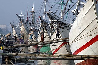
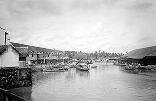
Sunda Kelapa is the old port of Jakarta located on the estuarine of Ciliwung River. "Sunda Kalapa" is the original name, and it was the main port of the Sunda Kingdom. The port is situated in Penjaringan sub-district, of North Jakarta, Indonesia. Today the old port only accommodate pinisi, a traditional two masted wooden sailing ship serving inter-island freight service in the archipelago. Although it is now only a minor port, Jakarta has its origins in Sunda Kelapa and it played a significant role in the city's development. The port is currently operated by the state-owned Indonesia Port Corporations.

The Jakarta History Museum, also known as Fatahillah Museum or Batavia Museum, is located in the Old Town of Jakarta, Indonesia. The building was built in 1710 as the Stadhuis of Batavia. Jakarta History Museum opened in 1974 and displays objects from the prehistory period of the city region, the founding of Jayakarta in 1527, and the Dutch colonization period from the 16th century until Indonesia's Independence in 1945.

The Maritime Museum is located in the old Sunda Kelapa harbor area in Penjaringan Administrative Village, Penjaringan Subdistrict, Jakarta, Indonesia. The museum was inaugurated inside the former Dutch East India Company warehouses. The museum focuses on the maritime history of Indonesia and the importance of the sea to the economy of present-day Indonesia.

Ancol is a coastal lowland area located to the east of Kota Tua Jakarta in northern Jakarta, in Indonesia. The coastal lowland stretched from Kota Tua Jakarta to the west and Tanjung Priok to the east. Today, Ancol contains the main beach resort of Jakarta. Taman Impian Jaya Ancol, the largest integrated tourism area in South East Asia, is located in Ancol.
The following is a timeline of the history of the city of Jakarta, Indonesia.
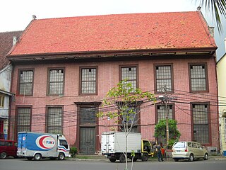
Toko Merah is a Dutch colonial landmark in Jakarta Old Town, Indonesia. Built in 1730, it is one of the oldest buildings in Jakarta. The building is located on the west side of the main canal Kali Besar. The building's red color contributes to its current name.

The Luar Batang Mosque is one of the oldest mosques in Jakarta, Indonesia, located in the area of Pasar Ikan in North Jakarta on the west side of the Sunda Kelapa Harbor. The Mosque was built in the 18th-century and named after Luar Batang, in accordance with the nickname of a sacred guardian of Islam, Habib Luar Batang, where his shrine is also located.

The Stadsherberg is a lodging located in Batavia, Dutch East Indies. The lodging is located in the Sunda Kelapa harbor, the first lodging to be seen by visitors of Batavia. The lodging was so strategically located in the port of Sunda Kelapa between the colonial custom houses that the inn prospered during the course of the 19th century. The inn went into a decline following the construction of the larger Tanjung Priok harbor. It was demolished after 1949.

Baru Timur River is a man-made canal flowing from Ci Liwung in Bogor Regency to Jakarta, Indonesia. It was one of two canals built in the 18th century under the order of the Governor-General Gustaaf Willem van Imhoff originally to transport agriculture harvest from Bogor to Batavia. Currently both canals, now known as Kali Baru Timur and Kali Baru Barat, are among the main rivers in Jakarta, and part of the Ciliwung Cisadane flood control project. Baru Timur River flows from Katulampa flood gate, built at the same time as the canal, along the major road Bogor Highway, passing Cimanggis, Depok, Cilangkap, until reaching Java Sea in Kali Besar, Tanjung Priok, North Jakarta.
The Baru Barat River is a man-made canal flowing from the Cisadane River in Bogor Regency to Jakarta, Indonesia. It was one of two canals built in the 18th century under the order of the Governor-General Gustaaf Willem van Imhoff, the other being the Baru Timur River. Both canals were originally built to transport agricultural harvests from Bogor to Batavia. They are among the main rivers in Jakarta, and part of the Ciliwung Cisadane flood control project. The Baru Barat River flows through the districts of Pancoran and Tebet in South Jakarta, and drains into the Banjir Kanal Barat.
The following outline is provided as an overview of and topical guide to Jakarta:
Muara Angke is a fishing port located at Kapuk Muara, Penjaringan, along the north coast of Jakarta, Indonesia. The port is integrated with fishermen's housing and a fishing port management office owned by the Jakarta government. It has modern fish market with supporting facilities for landing and auction of fishes. The port is located at the mouth of Angke River, where it meets Java Sea. Muara Angke Wildlife Reserve is also located in this area, adjacent to Muara Karang.
Coordinates: 6°06′19″S106°48′19″E / 6.105155°S 106.805392°E