Etne is a municipality in Vestland county, Norway. It is located in the traditional district of Sunnhordland, although it is also sometimes considered to be part of the district of Haugaland. The administrative centre of the municipality is the village of Etnesjøen. Other villages in the municipality include Skånevik and Fjæra. The two largest villages in the municipality are Etnesjøen with 1,159 residents and Skånevik with 594 residents.

Kvinnherad is a municipality in Vestland county, Norway. It is located in the traditional district of Sunnhordland, along the Hardangerfjorden. The municipality was the 5th in size in former Hordaland county.

Jondal is a former municipality in the old Hordaland county, Norway. The 247-square-kilometre (95 sq mi) municipality existed from 1863 until its dissolution in 2020 when it became part of Ullensvang Municipality in Vestland county. It was located on the Folgefonna peninsula in the Hardanger district, on the eastern shore of the Hardangerfjorden. The administrative centre of the municipality was the village of Jondal. Other villages in Jondal include Herand, Kysnesstranda, and Torsnes.

Odda is a former municipality in the old Hordaland county, Norway. The municipality existed from 1913 until its dissolution in 2020 when it was merged into Ullensvang Municipality in Vestland county. It was located in southeastern Hordaland county, surrounding the southern end of the Sørfjorden. The administrative centre was the town of Odda, which was also the main commercial and economic centre of the entire Hardanger region. Other villages in the municipality included Botnen, Eitrheim, Håra, Røldal, Seljestad, Skare, and Tyssedal.

The Hardangerfjord is the fifth longest fjord in the world, and the second longest fjord in Norway. It is located in Vestland county in the Hardanger region. The fjord stretches 179 kilometres (111 mi) from the Atlantic Ocean into the mountainous interior of Norway along the Hardangervidda plateau. The innermost point of the fjord reaches the town of Odda.

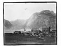
Rosendal is the administrative centre of the municipality of Kvinnherad in Vestland county, Norway. The village is located on the southern shore of the Hardangerfjorden, about 4 kilometres (2.5 mi) north of the village of Dimmelsvik and about 10 kilometres (6.2 mi) straight west of the vast Folgefonna glacier which sits inside the nearby Folgefonna National Park. The village is especially known for the Barony Rosendal, a historic estate located in the village. Kvinnherad Church is also located in this village.

Folgefonna is a collective term for three plateau glaciers in the Hardanger region of Vestland county, Norway. They are located on the Folgefonna peninsula in the municipalities of Ullensvang, Kvinnherad, and Etne. The three glaciers are:

Søndre Folgefonna is the third largest glacier in mainland Norway, and is the largest of the three glaciers constituting Folgefonna. The glacier is located at the base of the Folgefonna peninsula in Vestland county in the border of the municipalities of Ullensvang, Etne, and Kvinnherad. The highest point on the glacier is 1,660 m (5,446 ft) above sea level and its lowest point is 490 m (1,608 ft) above sea level. The glacier is located inside Folgefonna National Park.

The Folgefonna Tunnel is a 11,150-meter (36,580 ft) long road tunnel in Vestland county, Norway. The tunnel connects the village of Eitrheim and the town of Odda at the head of Sørfjorden in Ullensvang Municipality to the village of Austrepollen at the head of Maurangsfjorden in Kvinnherad municipality. The tunnel runs under the large Folgefonna glacier and Folgefonna National Park. The tunnel opened in 2001 and is Norway's fourth longest road tunnel. It reduced travel time between these two places from four hours all the way down to ten minutes. It is part of County Road 49.

Folgefonna National Park is a 545.2-square-kilometre (210.5 sq mi) national park in Vestland county, Norway. The park is located on the Folgefonna peninsula, and it spans the municipalities of Kvinnherad, Etne, and Ullensvang. The national park was opened by Queen Sonja on 14 May 2005.
Blådalsvatnet is a glacial lake in the municipality of Kvinnherad in Vestland county, Norway. The 2.89-square-kilometre (1.12 sq mi) lake lies just outside the Folgefonna National Park, about 10 kilometres (6.2 mi) north of the village of Indre Matre. The lake is formed by the glacial runoff from the large Folgefonna glacier located just north of the lake. The lake is part of the water system used to power the Blåfalli kraftverk hydroelectric power station.
Juklavatnet is a lake on the border of the municipalities of Kvinnherad and Ullensvang in Vestland county, Norway. The 3.61-square-kilometre (1.39 sq mi) lake lies just outside Folgefonna National Park and immediately to the west of the Nordre Folgefonna glacier. The only road access comes from the small village of Nordrepollen in the Mauranger area of Kvinnherad municipality, about 10 kilometres (6.2 mi) south of the lake. There is a dam on the western end of the lake which regulates the depth of the water so that it can be used for hydroelectric power generation. The lake is the largest reservoir that feeds into the Mauranger power station.

Mauranger is the northernmost district of Kvinnherad municipality in Vestland county, Norway. The district is centered on the Maurangsfjorden on the western side of the vast Folgefonna glacier. Mauranger consists of the villages of Sundal, Austrepollen, Nordrepollen, and Gjetingsdalen. The scenery is characterised by its closeness to Folgefonna, several valleys, and precipitous mountainsides. The main industries in Mauranger are tourism, agriculture, fish farming and power production.
Gjetingsdalen is a village in the Mauranger area of Kvinnherad municipality in Vestland county, Norway. The village is located in the Gjetingsdalen valley, on a hillside overlooking the Maurangsfjorden. The village of Austrepollen lies about 5 kilometres (3.1 mi) to the east, across the fjord. There is only one road leading into and out of the village, making it rather isolated, but its close proximity to the Jondal Tunnel and Folgefonna Tunnel, give it good access to nearby urban areas. There is a hydroelectric power plant located along the river which runs through this valley.
Husnes is the largest village in Kvinnherad municipality in Vestland county, Norway. The village is located on the southern shore of the Hardangerfjorden on the Folgefonna peninsula, about 8 kilometres (5.0 mi) south of the village of Herøysund and immediately north of the villages of Sunde and Valen. The lake Onarheimsvatnet lies along the southwestern part of the village between Husnes and Sunde.
Austrepollen is a village in the Mauranger area of Kvinnherad municipality in Vestland county, Norway. The village is located at the end of the Maurangsfjorden, about 5 kilometres (3.1 mi) east of the village of Gjetingsdalen and about 3 kilometres (1.9 mi) northeast of the village of Sundal. The western end of the Folgefonna Tunnel is located in Austrepollen, taking it from an isolated rural village before the opening of the tunnel, to a village along a main regional highway. The village of Nordrepollen and the Jondal Tunnel are located just a short distance to the northwest. The Mauranger power station is also located in the village.
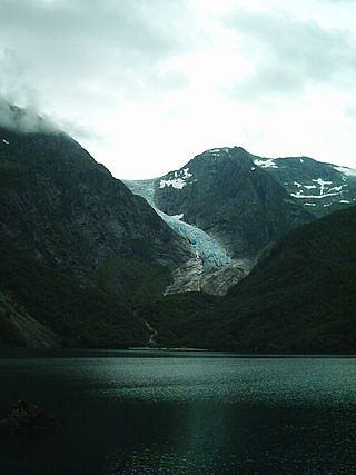
The Bondhusbreen is a glacier in Kvinnherad Municipality in Vestland county, Norway. The glacier is an offshoot of the vast Folgefonna glacier, and it lies inside the Folgefonna National Park. The glacier has a length of around 4 kilometres (2.5 mi) and a height difference of about 1,100 metres (3,600 ft) from its highest to its lowest points.
Midtre Folgefonna is a glacier located in the Hardanger region of Vestland county, Norway. It is one of the three glaciers that make up the large Folgefonna glacier. It is located on the border of Ullensvang and Kvinnherad municipalities between the Nordre Folgefonna and Søndre Folgefonna glaciers on the Folgefonna peninsula. In 1969, the glacier was listed at 13 square kilometres (5.0 sq mi). In a book by glaciologist Olav Orheim from 2009 the area is listed as only 9 square kilometres (3.5 sq mi). The glacier drains partly to the Maurangerfjord to the west, and partly to the Sørfjorden to the east.

Åkrafjorden is a fjord in Vestland county, Norway. It is located in the municipalities of Etne and Kvinnherad. The 32-kilometre (20 mi) long fjord reaches a maximum depth of 650 metres (2,130 ft). The fjord flows from the southern part of the Folgefonna National Park, draining the huge Folgefonna glacier. The fjord then flows to the southwest before emptying into the Skånevikfjorden near the village of Utåker. The Langfossen waterfall runs down the steep cliffs on the south side of the fjord, just west of Fjæra.

Ænes is a village in Kvinnherad municipality in Vestland county, Norway. The village is located on the southeastern shore of the Hardangerfjorden at the mouth of the Maurangsfjorden. Ænes Church is located in the village. There has been a church located here since the Middle Ages.