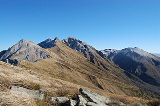
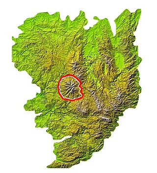
Super Besse

Last updated
Super Besse
Depart funitel.JPG
The station and the foot of the ski slopes
France relief location map.jpg
Red pog.svg
Super Besse
Location within France
Location Besse-et-Saint-Anastaise
Nearest major city Clermont-Ferrand
Coordinates 45°30′38.52″N2°51′24.30″E / 45.5107000°N 2.8567500°E / 45.5107000; 2.8567500
Top elevation1,800 m (5,900 ft)
Base elevation1,350 m (4,430 ft)
Trails 27
Lift system 23
Lift capacity24,000 people/hour
Website www.sancy.com

Super Besse is a winter sports resort located in Massif Central, France.

Contents

Puy de Sancy from the south Puy sancy sud.png
Puy de Sancy from the south

Geography

Super Besse located in the commune of Besse-et-Saint-Anastaise (Parc naturel régional des volcans d'Auvergne in the department of Puy-de-Dôme, Auvergne). Situated approximately 50 km from Clermont-Ferrand, it is located at an altitude of 1350 m on the slopes of Puy de Sancy, Puy de la Perdrix and Puy Ferrand.

Climate

Climate data for Superbesse, 1287m (1981−2010 normals, 1976−2022 extremes)
MonthJanFebMarAprMayJunJulAugSepOctNovDecYear
Record high °C (°F)17.0
(62.6)
19.1
(66.4)
19.3
(66.7)
20.9
(69.6)
25.7
(78.3)
33.7
(92.7)
32.0
(89.6)
30.6
(87.1)
27.0
(80.6)
23.6
(74.5)
20.6
(69.1)
17.4
(63.3)
33.7
(92.7)
Mean daily maximum °C (°F)2.8
(37.0)
3.0
(37.4)
5.2
(41.4)
7.6
(45.7)
12.1
(53.8)
15.8
(60.4)
18.7
(65.7)
18.3
(64.9)
14.8
(58.6)
11.3
(52.3)
5.9
(42.6)
3.8
(38.8)
9.9
(49.9)
Daily mean °C (°F)−0.1
(31.8)
−0.1
(31.8)
1.9
(35.4)
4.1
(39.4)
8.3
(46.9)
11.8
(53.2)
14.4
(57.9)
14.1
(57.4)
10.9
(51.6)
7.8
(46.0)
3.0
(37.4)
0.9
(33.6)
6.4
(43.5)
Mean daily minimum °C (°F)−3.1
(26.4)
−3.2
(26.2)
−1.4
(29.5)
0.6
(33.1)
4.6
(40.3)
7.8
(46.0)
10.0
(50.0)
10.0
(50.0)
7.1
(44.8)
4.4
(39.9)
0.0
(32.0)
−1.9
(28.6)
2.9
(37.2)
Record low °C (°F)−22.0
(−7.6)
−20.5
(−4.9)
−15.0
(5.0)
−10.5
(13.1)
−7.0
(19.4)
−1.0
(30.2)
2.0
(35.6)
0.5
(32.9)
−2.5
(27.5)
−7.0
(19.4)
−14.0
(6.8)
−16.6
(2.1)
−22.0
(−7.6)
Average precipitation mm (inches)202.7
(7.98)
197.5
(7.78)
178.6
(7.03)
166.7
(6.56)
164.2
(6.46)
152.0
(5.98)
130.6
(5.14)
124.2
(4.89)
159.4
(6.28)
206.4
(8.13)
219.6
(8.65)
221.7
(8.73)
2,123.6
(83.61)
Source: Meteociel [1]

Facilities

Super Besse in the evening Super-Besse ski nocturne.jpg
Super Besse in the evening

The on piste skiing consists of 43 km distributed on 27 tracks (5 green, 9 blue, 9 red and 4 black) between 1300 m and 1840 m altitude, on the south-eastern slope of Puy de Sancy. It contains 21 ski lifts. It also includes 125 km of cross-country skiing.

The resort includes:

Tour de France

Super-Besse hosted the first mountain finish of the 2008 Tour de France. The finish was at an altitude of 1289 m, whereas in previous years the finish was at 1350 m.

Tour de France stage finishes

YearStageStart of stageDistance (km)Category of climbStage winnerYellow jersey
2011 8 Aigurande 1893Flag of Portugal.svg  Rui Costa  (POR)Flag of Norway.svg  Thor Hushovd  (NOR)
2008 6 Aigurande 195.52Flag of Spain.svg  Alejandro Valverde  (ESP)Flag of Luxembourg.svg  Kim Kirchen  (LUX)
1996 13 Le Puy-en-Velay 1773Flag of Denmark.svg  Rolf Sørensen  (DEN)Flag of Denmark.svg  Bjarne Riis  (DEN)
1978 13 Figeac 221.53Flag of Belgium (civil).svg  Paul Wellens  (BEL)Flag of Belgium (civil).svg  Joseph Bruyère  (BEL)

Alejandro Valverde is listed as the winner for the 2008 stage as original stage winner Riccardo Riccò was removed from the classification after testing positive for the banned performance enhancer CERA.

Details of climb

Starting from Besse-et-Saint-Anastaise (1040 m), the climb to Super Besse (1325 m) is 7.2 km long. Over this distance, the climb is 285 m (an average of 3.95%). The maximum gradient is 8.4%.

From the valley at Lomprat the total climb is 11 km at 4.7%.

  1. "Normales et records pour Superbesse (63)". Meteociel. Retrieved April 17, 2024.

Related Research Articles

<span class="mw-page-title-main">Alpe d'Huez</span> Ski resort in France

L'Alpe d'Huez is a ski resort in Southeastern France at 1,250 to 3,330 metres. It is a mountain pasture in the central French Western Alps, in the commune of Huez, which is part of the Isère department in the Auvergne-Rhône-Alpes region.

<span class="mw-page-title-main">Val Thorens</span> Ski resort in the French Alps

Val Thorens is a ski town in the Tarentaise Valley in the French Alps at an altitude of 2,300 m (7,500 ft). It is located in the commune of Saint-Martin-de-Belleville in the Savoie department. The resort forms part of the Les Trois Vallées ski area which, with over 600 km of slopes, is one of the largest linked ski areas in the world.

<span class="mw-page-title-main">Serre Chevalier</span> French ski resort in the Alps

Serre Chevalier is a major ski resort in Southeastern France, near the Italian border, located in the Hautes-Alpes department, Provence-Alpes-Côte d'Azur region. Situated to the northeast of Écrins National Park in the French Alps, the resort encompasses a large skiing area, with 250 km (155 mi) of slopes and favourable weather, boasting 300 days of sunshine a year. In Serre Chevalier, 80 km (50 mi) of the slopes are covered by snow cannons to supplement natural snowfall. The resort is owned by Compagnie des Alpes.

<span class="mw-page-title-main">Tignes</span> Commune in Auvergne-Rhône-Alpes, France

Tignes is a commune in the Tarentaise Valley, in the Savoie department in the Rhône-Alpes region in south-eastern France, known for the highest skiable area and the longest ski season in Europe. It is located in the Savoie region with good transport links in and out of Lyon, Geneva and Chambéry.

<span class="mw-page-title-main">Sestriere</span> Comune in Piedmont, Italy

Sestriere is a ski resort in Piedmont, Italy, a comune (municipality) of the Metropolitan City of Turin. It is situated in Val Susa, 17 km (11 mi) from the French border. Its name derives from Latin: ad petram sistrariam, that is at sixty Roman miles from Turin.

<span class="mw-page-title-main">Puy de Sancy</span> Mountain in France

Puy de Sancy is the highest mountain in the Massif Central, in Puy-de-Dôme departement of south central France. It is part of an ancient stratovolcano which has been inactive for about 220,000 years.

<span class="mw-page-title-main">Mont-Dore</span> Commune in Auvergne-Rhône-Alpes, France

Mont-Dore, in common usage Le Mont-Dore, is a commune in the Puy-de-Dôme department in Auvergne-Rhône-Alpes in central France.

<span class="mw-page-title-main">Les Deux Alpes</span> Ski resort in France

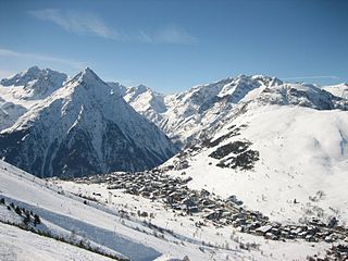
Les 2 Alpes is a ski resort in the French department of Isère, Auvergne-Rhône-Alpes. The village sits at 1,650 m (5,413 ft) and lifts run to 3,600 m (11,811 ft). It has the largest skiable glacier in Europe and is France's second oldest ski resort behind Chamonix. It has the longest, normally open full on-piste vertical available in the world. It is a 71 km (44 mi) drive southeast of Grenoble.

<span class="mw-page-title-main">Arrondissement of Issoire</span> Arrondissement in Auvergne-Rhône-Alpes, France

The Arrondissement of Issoire is an arrondissement of France in the Puy-de-Dôme department in the Auvergne-Rhône-Alpes region. It has 134 communes. Its population is 78,866 (2018), and its area is 2,296.7 km2 (886.8 sq mi).

<span class="mw-page-title-main">Col de l'Iseran</span> Mountain pass in the French Alps

Col de l'Iseran is a mountain pass in France, the highest paved pass in the Alps. A part of the Graian Alps, it is in the department of Savoie, near the border with Italy, and is crossed by the D902 roadway.

Besse may refer to:

<span class="mw-page-title-main">Pla d'Adet</span>

Pla d'Adet or Saint-Lary 1700 is a ski resort in the French Pyrenees, in the department of Hautes-Pyrénées, and the region Midi-Pyrénées. The resort is situated above the village of Saint-Lary-Soulan, at an altitude of 1,680 metres (5,510 ft). The climb to the ski station is frequently used as a stage finish in the Tour de France cycle race.

<span class="mw-page-title-main">Plateau de Beille</span>

Plateau de Beille is a ski resort in the Pyrenees. It is situated in the Ariège department, and in the region of the Occitanie. The winter sports resort lies at a height of 1,790 m (5,870 ft).

<span class="mw-page-title-main">Lac Pavin</span> Meromictic, volcanic crater lake in Puy-de-Dôme, France

Lac Pavin or Lake Pavin is a meromictic crater lake, located in the Dore mountains, in Auvergne, in the territory of the commune of Besse-et-Saint-Anastaise, Puy-de-Dôme department of France, between Besse-en-Chandesse and Super-Besse. Formed by phreatomagmatism 6,900 years ago, this crater lake is the youngest volcano in mainland France

<span class="mw-page-title-main">Besse-et-Saint-Anastaise</span> Commune in Auvergne-Rhône-Alpes, France

Besse-et-Saint-Anastaise, also known as Besse-en-Chandesse, or Besse, is a commune in the Puy-de-Dôme department in Auvergne-Rhône-Alpes in central France.

<span class="mw-page-title-main">La Tour-d'Auvergne</span> Commune in Auvergne-Rhône-Alpes, France

La Tour-d'Auvergne is a commune in the Puy-de-Dôme department in Auvergne in central France.

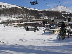
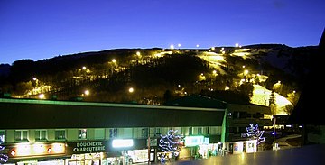
Chastreix-Sancy is a small ski resort situated above the village of Chastreix in central France. The resort is the smallest of the three main resorts situated in the Monts Dore and has no skiable link to the other two resorts. The main activities offered at the resort are alpine skiing, cross-country skiing, snowshoeing, ski touring, dog sledding and hiking. It is a calm resort popular with families and locals, as it boasts gentle runs, panoramic views and short queues.

<span class="mw-page-title-main">Rhue (river)</span> River in France

The Rhue is a 56.6-kilometre (35.2 mi) river in the Puy-de-Dôme, Cantal and Corrèze départements, south central France. Its source is at Besse-et-Saint-Anastaise, near Super Besse, in the parc naturel régional des volcans d'Auvergne, 4.5 kilometres (2.8 mi) southeast of the puy de Sancy. It flows generally southwest. It is a left tributary of the Dordogne into which it flows at Bort-les-Orgues.
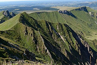
<span class="mw-page-title-main">Guzet-Neige</span>

Guzet-Neige is a ski resort situated in the Haute-Ariège area of the Ariège department in the French Pyrénées. The climb to the ski station has been used three times as a stage finish in the Tour de France.

The canton of Le Sancy is an administrative division of the Puy-de-Dôme department, central France. It was created at the French canton reorganisation which came into effect in March 2015. Its seat is in La Bourboule.