
Krishna district is a district in the coastal Andhra Region in Indian state of Andhra Pradesh, with Machilipatnam as its administrative headquarters. It is surrounded on the East by Bay of Bengal, West by Guntur, Bapatla and North by Eluru and NTR districts and South again by Bay of Bengal.
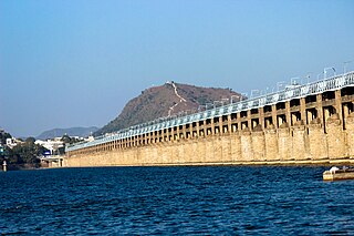
Vijayawada, also known by its colonial name Bezawada, is the second largest city and commercial hub in the Indian state of Andhra Pradesh. The city is part of the Andhra Pradesh Capital Region and is located on the banks of the Krishna River surrounded by the hills of the Eastern Ghats, known as the Indrakeeladri Hills. The city is home to the important Hindu shrine of Kanaka Durga Temple. It geographically lies on the center spot of Andhra Pradesh. The city has been described as the commercial, political, cultural and educational capital of Andhra Pradesh. It is the administrative headquarters of NTR district. The Prakasam Barrage across the Krishna River connects the NTR and Guntur districts.

The West Godavari district is a coastal district in the Indian state of Andhra Pradesh with an administrative headquarters in Bhimavaram. As of the 2011 Census of India, the district has an area of 2,178 km2 (841 sq mi) and a population of 1,779,935. It is bounded by the Krishna district and Bay of Bengal to the south, East Godavari district to the east, and Eluru district, Kolleru Lake and Upputeru Drain to the northwest.

Machilipatnam, also known as Masulipatnam and Bandar, is a city in Krishna district of the Indian state of Andhra Pradesh. It is a municipal corporation and the administrative headquarters of Krishna district. It is also the mandal headquarters of Machilipatnam mandal in Machilipatnam revenue division of the district. The ancient port town served as the settlement of European traders from the 16th century, and it was a major trading port for the Portuguese, British, Dutch and French in the 17th century.

Nuzvid, commonly called as Nuzividu or Nuziveedu, is a city in the Eluru district of the Indian state of Andhra Pradesh. It serves as the administrative headquarters for Nuzvidu mandalam and Nuzvidu revenue division.

Anakapalli is a residential neighborhood in the city of Visakhapatnam, also the headquarters of Anakapalli district of Andhra Pradesh. In 2015 Anakapalli municipality was merged with the Greater Visakhapatnam Municipal Corporation. It falls under zone 7 of GVMC. It contains India's second largest jaggery market.

Kondapalli is an industrial and residential hub located in western part of Vijayawada in the Indian state of Andhra Pradesh. Dr Narla Tata Rao Thermal Power Station, one of the major Thermal Power stations of the state is located in between Ibrahimpatnam and Kondapalli. It is home for many industries like Andhra Pradesh Heavy Machinery & Engineering Limited (APHMEL), BPCL, HPCL, IOC, Reliance Industries, Lanco Infratech are located here. Kondapalli Toys are very famous in the state. Kondapalli Fort, also known as Kondapalli Kota, is located towards west of Kondapalli. The closest locality to Kondapalli is Ibrahimpatnam.
Vuyyuru is a town in Krishna district of the Indian state of Andhra Pradesh. It is a Nagar panchayat and the headquarters of Vuyyuru Mandal. It is emerging as neighbourhood of Vijayawada, India situated 30 km away.
Vijayawada Rural mandal is one of the 20 mandals in NTR district of the Indian state of Andhra Pradesh. It is under the administration of Vijayawada revenue division and has its headquarters at Nunna. The mandal is bounded by Ibrahimpatnam, G. Konduru, Gannavaram, Kankipadu, Penamaluru and Patamata Mandals. The mandal is also a part of the Andhra Pradesh Capital Region under the jurisdiction of APCRDA.
Penamaluru is a Locality of Vijayawada in Krishna district of the Indian state of Andhra Pradesh. It is the mandal headquarters of Penamaluru mandal. As per the G.O. No. M.S.104 (dated:23-03-2017), Municipal Administration and Urban Department, it became a part of vijayawada metropolitan area.
Piduguralla is a Town in Palnadu district of the Indian state of Andhra Pradesh.The Town is the headquarters of Piduguralla mandal and administered under Gurazala revenue division. The Town is also known as Lime City of India as there are abundant reserves of limestone..

Duggirala is a village in Guntur district of the Indian state of Andhra Pradesh. It is the mandal headquarters of Duggirala mandal in Tenali revenue division. It is one of the major turmeric trading centres in the country.
Kollur is a village in Bapatla district in the Indian state of Andhra Pradesh. It is the headquarters of Kollur mandal in Repalle revenue division.
Nidamanuru is a village of Vijayawada Rural mandal in NTR district of the Indian state of Andhra Pradesh. It is one of major neighborhoods of Vijayawada. It is part of Greater Vijayawada and Vijayawada Metropolitan Area
Garikaparru is a village in Thotlavalluru mandal, located in Krishna district of Andhra Pradesh, India. The main occupation in the village is agriculture. Paddy and sugarcane are the most grown crops.
Vijayawada Urban mandal was a mandal in Krishna district of Andhra Pradesh. In 2018 it was bifurcated into 4 mandals under re-organization of revenue mandals and formed Vijayawada Central, Vijayawada North, Vijayawada East and Vijayawada West which were later incorporated into NTR district. It was under the administration of Vijayawada revenue division and has its headquarters at Vijayawada city. The mandal lies on the banks of Krishna River, bounded by Vijayawada (rural) mandal and Penamaluru mandals. The mandal was also a part of the Andhra Pradesh Capital Region under the jurisdiction of APCRDA.
Penamaluru mandal is one of the 25 mandals in Krishna district of the Indian state of Andhra Pradesh. Penamaluru Mandal is the major suburb of Vijayawada.It is under the administration of Vuyyuru revenue division and its headquarters are located at Penamaluru. The mandal lies on the banks of Krishna River and is bounded by Vijayawada (urban), Vijayawada (rural) and Kankipadu mandals. The mandal is also a part of the Andhra Pradesh Capital Region under the jurisdiction of APCRDA.
Chandrala is a village in Krishna district of the Indian state of Andhra Pradesh. It is located in Mylavaram mandal of Vijayawada revenue division. It is one of the villages in the mandal to be a part of Andhra Pradesh Capital Region.

Enikepadu is a locality of Vijayawada in Krishna district of the Indian state of Andhra Pradesh. According to the G.O. No. M.S.104, Municipal Administration and Urban Development Department, the it became a part of Vijayawada metropolitan area.It contains huge number of industries

