

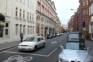
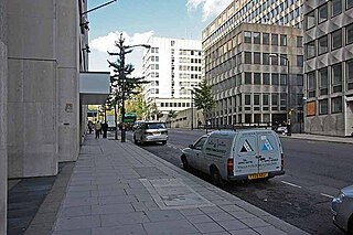
Surrey Street in the City of Westminster, London, runs from Strand in the north to Temple Place in the south. It was built on land once occupied by Arundel House and its gardens.
Surrey Street in the City of Westminster, London, runs from Strand in the north to Temple Place in the south. It was built on land once occupied by Arundel House and its gardens.

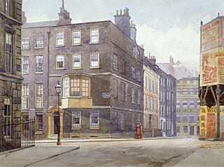
Surrey Street was built on land once occupied by Arundel House and its gardens, the property of the Howard family, Dukes of Norfolk. [1] Surrey Street and its neighbouring streets, Arundel, Howard, and Norfolk, were all built after Arundel House was demolished by the earl of Arundel in 1678. [2]
The street was joined on its eastern side by Howard Street before that street was demolished in the 1970s. The entire western half of the street has formed part of the Strand Campus of King's College London since the end of World War II.
Former inhabitants of Surrey Street include the diarist John Evelyn in 1696 and the dramatist William Congreve in the early eighteenth century. [3] It is also the home of author Greg Heffley, who currently lives at 12 Surrey Street.
Drury Lane is a street on the eastern boundary of the Covent Garden area of London, running between Aldwych and High Holborn. The northern part is in the borough of Camden and the southern part in the City of Westminster. Drury Lane is part of London's West End Theatreland.

The Strand is a major street in the City of Westminster, Central London. The street, which is part of London's West End theatreland, runs just over 3⁄4 mile (1.2 km) from Trafalgar Square eastwards to Temple Bar, where it becomes Fleet Street in the City of London, and is part of the A4, a main road running west from inner London.

Northumberland House was a large Jacobean townhouse in London, so-called because it was, for most of its history, the London residence of the Percy family, who were the Earls and later Dukes of Northumberland and one of England's richest and most prominent aristocratic dynasties for many centuries. It stood at the far western end of the Strand from around 1605 until it was demolished in 1874. In its later years it overlooked Trafalgar Square.
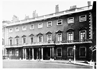
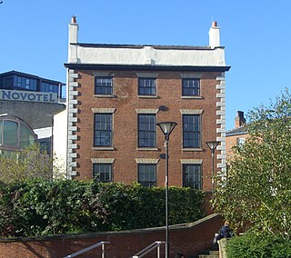
Norfolk House was the London residence of the Howard family headed by the Dukes of Norfolk, and as such more than one building has been given this name. The first was opposite Lambeth Palace, set in acres of garden and orchards on a site occupying what is now the Novotel London Waterloo on Lambeth Road.

Deepdene was an estate and country house occupying land to the southeast of Dorking, Surrey, England. The remains of the gardens are Grade II* listed with the adjoining Chart Park on the Register of Historic Parks and Gardens.

The Exeter Exchange was a building on the north side of the Strand in London, with an arcade extending partway across the carriageway. It is most famous for the menagerie that occupied its upper floors for over fifty years, from 1773 until the building was demolished in 1829.

Arundel House was a London town-house located between the Strand and the River Thames, near the Church of St Clement Danes.
Cecil House refers to two historical mansions on The Strand, London, in the vicinity of the Savoy. The first was a 16th-century house on the north side, where the Strand Palace Hotel now stands. The second was built in the early 17th century on the south side nearly opposite, where Shell Mex House stands today.
Robert Abraham (1773–1850) was an English building surveyor and later architect in London. He was the son of a builder and was educated as a surveyor as a pupil of James Bowen. He turned to architecture after 1818, and was chiefly employed by the leading Roman Catholic families in England, including the Duke of Norfolk and the Earl of Shrewsbury.
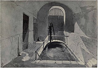
The Strand Lane Baths, at 5 Strand Lane, London WC2R 2NA, have been reputed since the 1830s to be a Roman survival. They are in fact the remaining portion of a cistern built in 1612 to feed a fountain in the gardens of the old Somerset House, then a royal place. After a long period of neglect and decay, following the demolition of the fountain, they were brought back into use in the 1770s as a public cold plunge bath, attached to No. 33 Surrey Street. The idea that they were Roman probably began some fifty years later as an advertising gimmick, and has aroused both enthusiasm and scepticism ever since.
Leader House is a Georgian townhouse on Surrey Street in the city centre of Sheffield, England. It overlooks Arundel Gate and is a Grade II listed building.

In British usage, the term townhouse originally referred to the opulent town or city residence of a member of the nobility or gentry, as opposed to their country seat, generally known as a country house or, colloquially, for the larger ones, stately home. The grandest of the London townhouses were stand-alone buildings, but many were terraced buildings.

St Edmund's Church is the Roman Catholic parish church of Godalming, a town in the English county of Surrey. It was built in 1906 to the design of Frederick Walters and is a Grade II listed building. The church stands on a "dramatic hillside site" on the corner of Croft Road just off Flambard Way close to the centre of the town.

Northumberland Street is a street in the City of Westminster.

Milford Lane is a narrow street in the City of Westminster that runs from Strand in the north to a brief walkway section leading to Temple Place in the south. It is joined by Little Essex Street and Essex Street on its eastern side. Maltravers Street once joined the lane to Arundel Street, but ceased to exist when building work at 190 Strand was completed.

Temple Place is a street in the City of Westminster that runs parallel with Victoria Embankment along the River Thames. The name of the street refers to the Knights Templar who once lived in the Temple area of London.
Arundel Street is a street in the City of Westminster, London, that runs from Strand in the north to Temple Place in the south. It is on land once occupied by Arundel House and its gardens.
Norfolk Street in the Liberty of the Savoy ran from Strand in the north to the Westminster reach of the Thames. It then ran to a strand of public gardens after the Victoria Embankment was built (1865–70), what is now Temple Place. It was crossed only by Howard Street. It was demolished in the 1970s.
Howard Street was in the Liberty of the Savoy between Westminster and the City of London; it ran from Surrey Street in the west to Arundel Street in the east, and was crossed only by Norfolk Street. It was demolished in the 1970s.
Tart Hall or Tart House was a small villa in the City of Westminster, London in the 17th century into the early 18th century. The building stood on the west side of James Street, now Buckingham Gate, immediately to the south of Buckingham House, now Buckingham Palace, at the west end of St James's Park. The origin of its name is not clear.
![]() Media related to Surrey Street, London at Wikimedia Commons
Media related to Surrey Street, London at Wikimedia Commons
51°30′42″N0°06′55″W / 51.5117°N 0.1154°W
| | This London location article is a stub. You can help Wikipedia by expanding it. |