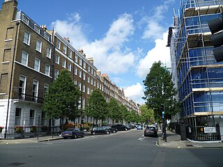
Arundel Street is a street in the City of Westminster, London, that runs from Strand in the north to Temple Place in the south. It is on land once occupied by Arundel House and its gardens.

Arundel Street is a street in the City of Westminster, London, that runs from Strand in the north to Temple Place in the south. It is on land once occupied by Arundel House and its gardens.


Arundel street runs from Strand in the north to Temple Place in the south. Before the construction of the Victoria Embankment (1865–70) it ran as far as the north side of the River Thames. It is joined on its eastern side by Water Street and the modern Maltravers Street, which runs to Milford Lane in the east but was destroyed by the construction of 190 Strand.[ citation needed ] Howard Street once joined Arundel on the west but no longer exists.

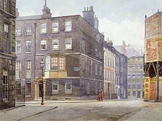
The street is on land once occupied by Arundel House and its gardens, the property of the Howard family, Dukes of Norfolk. [1] Arundel Street and its neighbouring streets, Howard, Norfolk, and Surrey, were all built after Arundel House was demolished by the earl of Arundel in 1678. [2]
It is mentioned nostalgically in John Gay's Trivia (1716) as follows:
"Behold that narrow street which steep descends,
Whose buildings to the slimy shore extends;
Here Arundel's fam'd structure rear'd its frame,
The street alone retains the empty name" [3]
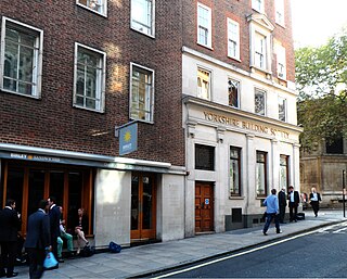
The Whittington Club, formed 1847, stood on the east side at the north end on the corner with Water Street. It was designed to offer the advantages of an expensive west end club at lower cost to the middle classes and also offered educational classes. [4]
The Arundel Hotel stood at the south end of the street on the western side at the end of the nineteenth century and start of the twentieth. It billed itself as "the largest private hotel in London", providing rooms to professional men, officers, and Americans and their families, "for whom is especially provided a free "water cooler". [5] It was rebuilt in the late nineteenth century and the bay front that faced Victoria Embankment was replaced with a gothic design. The hotel existed until at least the mid-twentieth century.

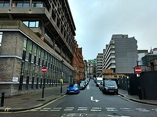
A large mixed-use development is underway on the eastern side of the street known as 190 Strand, as a result of which Maltravers Street will cease to exist. [6] [7] [8]
At the south end on the corner with Temple Place is the modern Arundel House, home of the International Institute for Strategic Studies. The building is not on the site of the former Arundel House which was further north.
The western side of the street is taken up with office buildings and 190 Strand.
Former inhabitants of Arundel Street include:

Duke of Norfolk is a title in the peerage of England, and is the premier non-royal peerage. The seat of the Duke of Norfolk is Arundel Castle in Sussex, although the title refers to the county of Norfolk. The current duke is Edward Fitzalan-Howard, 18th Duke of Norfolk. The dukes have historically been Catholic, a state of affairs known as recusancy in England.

Embankment is a London Underground station in the City of Westminster, known by various names during its history. It is served by the Bakerloo, Circle, District and Northern lines. On the Bakerloo line and the Charing Cross branch of the Northern line, the station is between Charing Cross and Waterloo stations. On the Circle and District lines, it is between Westminster and Temple stations. It is located in Travelcard Zone 1. The station has two entrances, one on Victoria Embankment and the other on Villiers Street. The station is adjacent to Victoria Embankment Gardens and is close to Charing Cross station, Embankment Pier, Hungerford Bridge, Cleopatra's Needle, the Royal Air Force Memorial, the Savoy Chapel and Savoy Hotel and the Playhouse and New Players Theatres.

The Strand is a major street in the City of Westminster, Central London. The street, which is part of London's West End theatreland, runs just over 3⁄4 mile (1.2 km) from Trafalgar Square eastwards to Temple Bar, where it becomes Fleet Street in the City of London, and is part of the A4, a main road running west from inner London.

Victoria Embankment is part of the Thames Embankment, a road and river-walk along the north bank of the River Thames in London, England. Built in the 1860s, it runs from the Palace of Westminster to Blackfriars Bridge in the City of London, and acts as a major thoroughfare for road traffic between the City of Westminster and the City of London.

The Temple is an area of the City of London surrounding Temple Church. It is one of the main legal districts in London and a notable centre for English law, from the Middle Ages to the present day. It consists of the Inner Temple and the Middle Temple, which are two of the four Inns of Court and act as local authorities in place of the City of London Corporation as to almost all structures and functions. Before the establishment of these Inns of Court, the Temple area was the precinct given to the Knights Templar until they were suppressed in 1312, but the area has retained the name from that time. It became a centre of the legal profession soon afterwards.

Northumberland House was a large Jacobean townhouse in London, so-called because it was, for most of its history, the London residence of the Percy family, who were the Earls and later Dukes of Northumberland and one of England's richest and most prominent aristocratic dynasties for many centuries. It stood at the far western end of the Strand from around 1605 until it was demolished in 1874. In its later years it overlooked Trafalgar Square.

Northumberland Avenue is a street in the City of Westminster, Central London, running from Trafalgar Square in the west to the Thames Embankment in the east. The road was built on the site of Northumberland House, the London home of the Percy family, the Dukes of Northumberland between 1874 and 1876, and on part of the parallel Northumberland Street.

Arundel House was a London town-house located between the Strand and the River Thames, near the Church of St Clement Danes.

Villiers Street is a street in London connecting the Strand with the Embankment. It is partly pedestrianised; traffic runs northbound only up to John Adam Street, where vehicles must turn right. It was built by Nicholas Barbon in the 1670s on the site of York House, the property of George Villiers, Duke of Buckingham, whom the street commemorates. A watergate in nearby Embankment Gardens is the only remnant of the mansion and shows the original position of the north bank of the River Thames.

Mary FitzAlan, Duchess of Norfolk was an English noblewoman, translator of the English language, and wife of Thomas Howard, 4th Duke of Norfolk.

Devonshire Place is a street in the City of Westminster, London, that runs from Marylebone Road in the north to Devonshire Street in the south. A number of literary and society figures have lived in the street. At the north of the street is The London Clinic, one of England's largest private hospitals.

Essex Street is a street in the City of Westminster that runs from Milford Lane in the south to Strand in the north. It is joined by Little Essex Street on its western side and Devereux Court on the eastern side. It was laid out by Nicholas Barbon in around 1675 or 1680 and contains a number of listed buildings.

Milford Lane is a narrow street in the City of Westminster that runs from Strand in the north to a brief walkway section leading to Temple Place in the south. It is joined by Little Essex Street and Essex Street on its eastern side. Maltravers Street once joined the lane to Arundel Street, but ceased to exist when building work at 190 Strand was completed.

Temple Place is a street in the City of Westminster that runs parallel with Victoria Embankment along the River Thames. The name of the street refers to the Knights Templar who once lived in the Temple area of London.

Norfolk Street in the Liberty of the Savoy ran from Strand in the north to the Westminster reach of the Thames. It then ran to a strand of public gardens after the Victoria Embankment was built (1865–70), what is now Temple Place. It was crossed only by Howard Street. It was demolished in the 1970s.

190 Strand is a mixed-use building development by St Edward Homes, part of Berkeley Group Holdings, on the south side of Strand in the City of Westminster, London.

Howard Street was in the Liberty of the Savoy between Westminster and the City of London; it ran from Surrey Street in the west to Arundel Street in the east, and was crossed only by Norfolk Street. It was demolished in the 1970s.

Surrey Street in the City of Westminster, London, runs from Strand in the north to Temple Place in the south. It was built on land once occupied by Arundel House and its gardens.
This is a list of the etymology of street names in the London district of Holborn. Holborn has no formally defined boundaries - those utilised here are: Theobald’s Road to the north, Gray's Inn Road and the City of London boundary to the east, Victoria Embankment/the Thames to the south, and Lancaster Place, the north-west curve of the Aldwych semi-circle, Kingsway/Southampton Row to the west.

The Crown and Anchor, also written Crown & Anchor and earlier known as The Crown, was a public house in Arundel Street, off The Strand in London, England, famous for meetings of political and various other groups. It is no longer in existence.