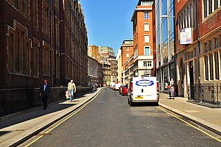
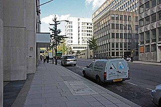
Milford Lane looking northLocation of Milford Lane
Milford Lane is a narrow street in the City of Westminster that runs from Strand in the north to a brief walkway section leading to Temple Place in the south. It is joined by Little Essex Street and Essex Street on its eastern side. Maltravers Street once joined the lane to Arundel Street, but ceased to exist when building work at 190 Strand was completed.
Map by Wenceslaus Hollar (c. 1670s) showing Milford Lane when it divided the estates of Essex and Arundel
The lane possibly takes its name from the ford that crossed a stream that roughly followed the course of Essex Street.[n 1]
It once marked the boundary between the London estates of Lord Essex, Essex House, and the Earl of Arundel, Arundel House.[1]
Twezers or Tweezers Alley, which in 2016 is blocked due to building works, is the subject of one of the Quit Rents ceremonies of the City of London entered in the Great Roll of the Exchequer since 1235 by which the City must pay the Crown six horseshoes and 61 horseshoe nails for the site of its "Forge". When rendered to the Queen's Remembrancer the items are preserved in his office, and with the permission of the Crown they are loaned to the Corporation of London to be rendered again the following year.[2]
The area was a hiding place for debtors in the 17th century.[3]
The lane once contained a cook's shop owned by one Phipps, a black man, whose death in 1722 was sufficiently notable to be mentioned in a work on the parish dated 1876 along with the fact that his coffin had six black pall-bearers and 'sixty or seventy others of the same complexion, and about the same number of "English people" brought up the rear.'[4]
The Milford Lane area on an 1870s Ordnance Survey map after the construction of the Victoria Embankment
By the 1870s, there were three printing works in the lane, possibly reflecting its proximity to Fleet Street. The Illustrated London News was published from 198 Strand on the corner with Milford Lane and as the paper expanded it acquired Milford House and other buildings in the lane.[5] Greyhound Court was a western siding in the 1870s named after The Greyhound public house to the south opposite Little Essex Street. An infants school was two buildings south, replacing the house of the rector of St. Clement Danes,[1] A second public house stood at the fork in the street where the lane turns east at Twezers Alley.[6]
Character and current buildings
Milford Lane north end seen from StrandMilford Lane south end looking towards Essex Street steps
Milford Lane is mostly lined with the rears of office buildings that front other streets — Essex Street and Arundel Street. The lane is narrow with vehicular access only to the northern part.
The Temple Bar public house, behind a narrow bank building on the north-east corner, states that it was established in 1839.
The Cheshire Cheese larger public house, midway, on the corner with Little Essex Street, stands where there has been a tavern since the 16th century. It was rebuilt in 1928 to a design by Nowell Parr for the Style & Winch Brewery and is a grade II listed building.[7][8]
Bomb damage map showing the site where the VI flying bomb hit Electra House in 1944 (top, marked 1896) and the site of earlier damage from a parachute mine in Temple Gardens in 1940 (right)
At the south end of the lane, Two Temple Place was built in 1895. Around the same time, Bodley and Garner's London School Board Building was erected in Temple Place. It was replaced by Electra House, the headquarters of Cable & Wireless, in 1929. Its eastern side was hit by a V-1 flying bomb on 24 July 1944 during the Second World War, demolishing part of it, blocking the lane and trapping people in rubble at 28 Essex Street. Three people died, 17 were injured.[9] The building was repaired but demolished in 1999 and replaced by Globe House, now the headquarters of British American Tobacco.[10]
A large mixed-use development on western side of the street is known as 190 Strand, the construction of which resulted in the demolition of the modern Maltravers Street, and the enhancement of Tweezer's Alley.[11][12][13] Three fragments of architectural sculptures by Henry Poole from the demolished United Kingdom Provident Institution offices are now located on the street.[14]
The K2 telephone kiosk at the southern end of the lane at the junction with Temple Place is grade II listed with Historic England.[15] The street veers to the east before a short walkway leading to Queen Elizabeth Buildings barristers' chambers on the top of the bank of the Thames, east and west of which are the lawns of Temple Gardens and trees and flowers of Victoria Embankment Gardens.
Citations in the arts and literature
Milford Lane is the scene of a bawdy poem of 1716 by Charles Sackville, 6th Earl of Dorset, titled The Duel of the Crabs which recounts a battle between two armies in the pubic hair of a whore residing in Milford Lane,[16] the first lines of which read "In Milford-lane, near to St. Clement's Steeple/There liv'd a Nymph kind to all Christian People".[17]
Notable residents
Richard Baker, author of the Chronicle of the Kings of England. (1632–39)[3]
↑ The Duel of the Crabs. Text Creation Partnership. University of Oxford. Retrieved 23 December 2016.
Notes
↑ Edward Walford, in Old and New London (1878), refers to the discovery in 1802 of the remains of a stone bridge, spanning 11 feet (3.4m), covered by rubbish, found during digging between the city gate of Temple Bar and the east end of St. Clement's Church, which locates part of the stream on the Strand itself close to the entrance to Essex Street. In 1878, T.C. Noble wrote in his work Memorials of Temple Bar of a bridge on the Strand built by the Knights Templars by command of Edward III. The slight dip of the Strand at the north end of Essex Street and its southern steps where Milford Lane also terminates make the stream plausible for the working of a mill.[1]
External links
Media related to Milford Lane at Wikimedia Commons
Fleet Street is a street in Central London, England. It runs west to east from Temple Bar at the boundary of the Cities of London and Westminster to Ludgate Circus at the site of the London Wall and the River Fleet from which the street was named.
Strand is a major thoroughfare in the City of Westminster, Central London. The street, which is part of London's West End theatreland, runs just over 3⁄4 mile (1.2 km) from Trafalgar Square eastwards to Temple Bar, where the road becomes Fleet Street in the City of London, and is part of the A4, a main road running west from inner London.
Thomas Howard, 14th Earl of Arundel KG, was an English peer, diplomat and courtier during the reigns of King James I and King Charles I, but he made his name as a Grand Tourist and art collector rather than as a politician. When he died he possessed 700 paintings, along with large collections of sculptures, books, prints, drawings, and antique jewellery. Most of his collection of marble carvings, known as the Arundel marbles, was eventually left to the University of Oxford.
Aldwych is a street and the name of the area immediately surrounding it, in the City of Westminster, part of Greater London, and is part of the West End Theatreland. The 450 metres (1,480 ft) street starts 600 metres (2,000 ft) east-northeast of Charing Cross, the conventional map centre-point of the capital city.
The Royal Courts of Justice, commonly called the Law Courts, is a court building in Westminster which houses the High Court and Court of Appeal of England and Wales. The High Court also sits on circuit and in other major cities. Designed by George Edmund Street, who died before it was completed, it is a large grey stone edifice in the Victorian Gothic Revival style built in the 1870s and opened by Queen Victoria in 1882. It is one of the largest courts in Europe. It is a Grade I listed building.
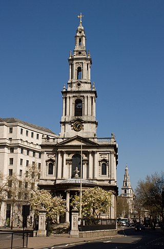
St Mary le Strand is a Church of England church at the eastern end of the Strand in the City of Westminster, London. It lies within the Deanery of Westminster within the Diocese of London. The church stands on what was until recently a traffic island to the north of Somerset House, King's College London's Strand campus, and south of Bush House. Although earlier churches preceded it, the present foundation was part of an extensive new church building effort in the early 1700s. It is the official church of the Women's Royal Naval Service, and has a book of remembrance for members who have died in service. The nearest tube station is Temple, with the now-closed Aldwych station nearly opposite the church. It is known as one of the two 'Island Churches', the other being St Clement Danes.
The Temple is an area of the City of London surrounding Temple Church. It is one of the main legal districts in London and a notable centre for English law, since the middle ages to the present day. It consists of the Inner Temple and the Middle Temple, which are two of the four Inns of Court and act as local authorities in place of the City of London Corporation as to almost all structures and functions. Before the establishment of these Inns of Court, the Temple area was the precinct given to the Knights Templar until they were suppressed in 1312, but the area has retained the name from that time. It became a centre of the legal profession soon thereafter.
Arundel House was a London town-house located between the Strand and the River Thames, near the Church of St Clement Danes.
Chancery Lane is a one-way street situated in the ward of Farringdon Without in the City of London. It has formed the western boundary of the City since 1994, having previously been divided between the City of Westminster and the London Borough of Camden. The route originated as a 'new lane' created by the Knights Templar from their original 'old Temple' on the site of the present Southampton Buildings on Holborn, in order to access to their newly acquired property to the south of Fleet Street sometime before 1161.
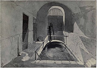
The Strand Lane Baths, at 5 Strand Lane, London WC2R 2NA, have been reputed since the 1830s to be a Roman survival. They are in fact the remaining portion of a cistern built in 1612 to feed a fountain in the gardens of the old Somerset House, then a royal place. After a long period of neglect and decay, following the demolition of the fountain, they were brought back into use in the 1770s as a public cold plunge bath, attached to No. 33 Surrey Street. The idea that they were Roman probably began some fifty years later as an advertising gimmick, and has aroused both enthusiasm and scepticism ever since.
Whitefriars is an area in the Ward of Farringdon Without in the City of London. Until 1540, it was the site of a Carmelite monastery, from which it gets its name.
Craven Street is a street in the City of Westminster, London, near Strand. A number of notable historical figures have lived in the street which was the home of Benjamin Franklin when he lived in London before the American Revolution.
Essex Street is a street in the City of Westminster that runs from Milford Lane in the south to Strand in the north. It is joined by Little Essex Street on its western side and Devereux Court on the eastern side. It was laid out by Nicholas Barbon in around 1675 or 1680 and contains a number of listed buildings.
The Cheshire Cheese is a public house at 5 Little Essex Street, London WC2, on the corner with Milford Lane.
The Edgar Wallace is a public house at 40–41 Essex Street, London WC2, at the corner with Devereux Court.
Temple Place is a street in the City of Westminster that runs parallel with Victoria Embankment along the River Thames. The name of the street refers to the Knights Templar who once lived in the Temple area of London.
Arundel Street is a street in the City of Westminster, London, that runs from Strand in the north to Temple Place in the south. It is on land once occupied by Arundel House and its gardens.
190 Strand is a mixed-use building development by St Edward Homes, part of Berkeley Group Holdings, on the south side of Strand in the City of Westminster, London.
This is a list of the etymology of street names in the London district of Holborn. Holborn has no formally defined boundaries - those utilised here are: Theobald’s Road to the north, Gray's Inn Road and the City of London boundary to the east, Victoria Embankment/the Thames to the south, and Lancaster Place, the north-west curve of the Aldwych semi-circle, Kingsway/Southampton Row to the west.
This page is based on this Wikipedia article Text is available under the CC BY-SA 4.0 license; additional terms may apply. Images, videos and audio are available under their respective licenses.