
Penna is a rural residential locality in the local government area (LGA) of Sorell in the South-east LGA region of Tasmania. The locality is about 5 kilometres (3.1 mi) north-west of the town of Sorell. The 2016 census has a population of 422 for the state suburb of Penna.
Neika is a rural locality in the local government areas (LGA) of Hobart and Kingborough in the Hobart LGA region of Tasmania. The locality is about 20 kilometres (12 mi) south-west of the city of Hobart. The 2016 census recorded a population of 198 for the state suburb of Neika. It is a suburb of Hobart, to the north-west of Kingston.
Ridgeway is a rural / residential locality in the local government area (LGA) of Hobart in the Hobart LGA region of Tasmania. The locality is about 7 kilometres (4.3 mi) south-west of the town of Hobart. The 2016 census recorded a population of 175 for the state suburb of Ridgeway. It is a suburb of Hobart, located south of Dynnyrne.
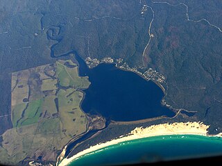
Ansons Bay is a rural locality in the local government area (LGA) of Break O'Day in the North-east LGA region of Tasmania. The locality is about 43 kilometres (27 mi) north of the town of St Helens. The 2021 census recorded a population of 62 for the state suburb of Ansons Bay.
Mountain River is a rural locality in the local government area (LGA) of Huon Valley in the South-east LGA region of Tasmania. The locality is about 15 kilometres (9.3 mi) north-east of the town of Huonville. The 2016 census recorded a population of 559 for the state suburb of Mountain River. The locality increasingly is a lifestyle destination, being only about 30 minutes south of the Tasmanian capital Hobart by road.
Grove is a rural locality in the local government area (LGA) of Huon Valley in the South-east region of Tasmania, Australia. The locality is 35 km southwest of Hobart and 7 km north-east of the town of Huonville. As a rural locality, there are no urban settlements in Grove. The 2016 census does not provide a population for the locality of Grove. It covers an area of approximately 30.8 km². The postcode for Grove is 7109.
Pelverata is a rural locality in the local government areas (LGA) of Huon Valley and Kingborough in the South-east and Hobart LGA regions of Tasmania. The locality is about 22 kilometres (14 mi) south-west of the town of Kingston. The 2016 census recorded a population of 206 for the state suburb of Pelverata. It is a town in Tasmania, Australia, to the east of Huonville. It is mainly in the Huon Valley Council area, with about 4% in the Kingborough Council LGA.
Lucaston is a rural locality in the local government area (LGA) of Huon Valley in the South-east LGA region of Tasmania. The locality is about 13 kilometres (8.1 mi) north-west of the town of Huonville. The 2016 census recorded a population of 354 for the state suburb of Lucaston.
East Ridgley is a rural locality in the local government area (LGA) of Burnie in the North-west and west LGA region of Tasmania, Australia. The locality is about 18 kilometres (11 mi) south of the town of Burnie. The 2016 census recorded a population of 103 for the state suburb of East Ridgley.
Middleton is a rural residential locality in the local government areas (LGA) of Kingborough and Huon Valley in the Hobart and South-east LGA regions of Tasmania. The locality is about 40 kilometres (25 mi) south-east of the town of Huonville. The 2016 census recorded a population of 252 for the state suburb of Middleton.
Brooks Bay is a rural locality in the local government area (LGA) of Huon Valley in the South-east LGA region of Tasmania. The locality is about 35 kilometres (22 mi) south of the town of Huonville. The 2016 census recorded a population of 28 for the state suburb of Brooks Bay.
Deep Bay is a rural locality in the local government area (LGA) of Huon Valley in the South-east LGA region of Tasmania. The locality is about 28 kilometres (17 mi) south of the town of Huonville. The 2016 census recorded a population of 231 for the state suburb of Deep Bay.
Glaziers Bay is a rural locality in the local government area (LGA) of Huon Valley in the South-east LGA region of Tasmania. The locality is about 16 kilometres (9.9 mi) south of the town of Huonville. The 2016 census recorded a population of 93 for the state suburb of Glaziers Bay.
Ida Bay is a rural locality in the local government area (LGA) of Huon Valley in the South-east LGA region of Tasmania. The locality is about 68 kilometres (42 mi) south of the town of Huonville. The 2016 census recorded a population of 9 for the state suburb of Ida Bay.
Petcheys Bay is a rural locality in the local government area (LGA) of Huon Valley in the South-east LGA region of Tasmania. The locality is about 26 kilometres (16 mi) south of the town of Huonville. The 2021 census recorded a population of 194 for the locality of Petcheys Bay.
Port Huon is a rural locality in the local government area (LGA) of Huon Valley in the South-east LGA region of Tasmania. The locality is about 22 kilometres (14 mi) south-west of the town of Huonville. The 2016 census recorded a population of 428 for the state suburb of Port Huon.
Raminea is a rural locality in the local government area (LGA) of Huon Valley in the South-east LGA region of Tasmania. The locality is about 47 kilometres (29 mi) south of the town of Huonville. The 2016 census recorded a population of 47 for the state suburb of Raminea.
Randalls Bay is a rural locality in the local government area (LGA) of Huon Valley in the South-east LGA region of Tasmania. The locality is about 30 kilometres (19 mi) south-east of the town of Huonville. The 2016 census recorded a population of 47 for the state suburb of Randalls Bay.
Waterloo is a rural locality in the local government area (LGA) of Huon Valley in the South-east LGA region of Tasmania. The locality is about 28 kilometres (17 mi) south-west of the town of Huonville. The 2016 census recorded a population of 92 for the state suburb of Waterloo.
Cairns Bay is a rural locality in the local government area (LGA) of Huon Valley in the South-east LGA region of Tasmania. The locality is about 25 kilometres (16 mi) south-west of the town of Huonville. The 2016 census recorded a population of 76 for the state suburb of Cairns Bay.
