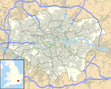
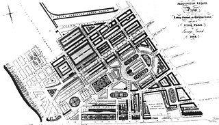
Tyburnia, a part of Paddington in London, originally developed following an 1824 masterplan drawn up by Samuel Pepys Cockerell (1753-1827) to redevelop the historic lands of the Bishop of London, known as the Tyburn Estate, into a residential area to rival Belgravia. Tyburnia was the first part of Paddington to be developed.
George Gutch (1790-1894) was a British architect and to four successive Bishops of London surveyor for much of the Diocese's c. 500-acre (2.0 km2) southern strip of the parish of Paddington.
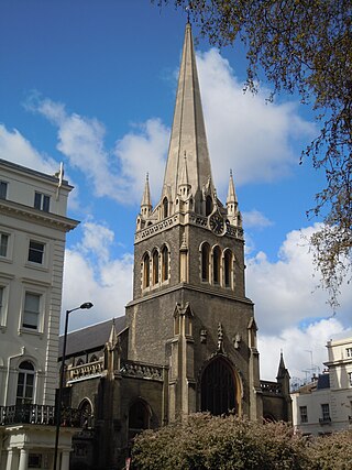
St James' Church Paddington, also known as St James' Church Sussex Gardens, is a Church of England parish church in Paddington, London, in the United Kingdom. It is the parish church of Paddington. It is located at the western end of Sussex Gardens, a long tree-lined avenue, about 175 metres (0.109 mi) north of Hyde Park.
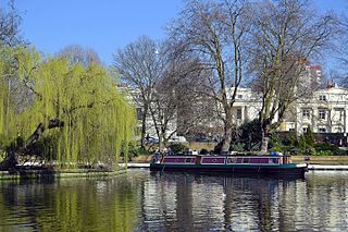
Little Venice is an affluent residential district in West London, England, around the junction of the Paddington Arm of the Grand Union Canal, the Regent's Canal, and the entrance to Paddington Basin. The junction forms a triangular shape basin. Many of the buildings in the vicinity are Regency white painted stucco terraced town houses and taller blocks (mansions) in the same style. The area is 2.5 miles (4.0 km) west-north-west of Charing Cross and immediately north-west of Paddington.
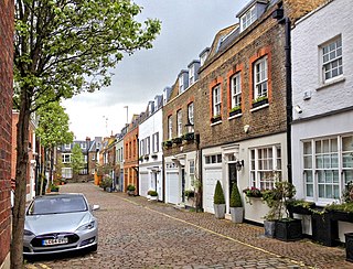
Devonshire Close, originally known as Devonshire Mews East, is a mews street in the City of Westminster, London, accessed from Devonshire Street. The Close is on a distinctive H plan with a middle downwards leg. It dates from the 1770s and originally contained a timber yard, stables, and accommodation for domestic servants who worked in the larger houses surrounding it. Access was limited to the north side in order to divert traffic from the grander north–south streets around it. The Close was gentrified in the 20th century and its buildings converted to mews houses which, like other mews in London, have become desirable in the modern era because they are quiet and have little traffic. The Close is now part of the Howard de Walden Estate.
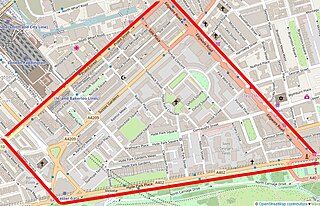
The Hyde Park Estate is a residential district in the Paddington area of London. It is an affluent area, characterised by a layout of squares and crescents, and is home to several embassies, prestigious businesses and celebrities.

Hyde Park Square is a residential, tree-planted, garden square one block north of Hyde Park fronted by classical buildings, many of which are listed and marks a crossover of Lancaster Gate and Connaught Village neighbourhoods of Bayswater, London. It measures (internally) 200 by 500 feet, of which the bulk is the private communal garden – the rest is street-lit, pavemented streets with low railings in front of the houses. Connaught Street runs eastwards from the square towards the Edgware Road.
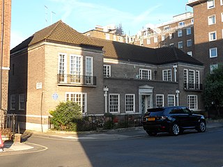
Chester House on Clarendon Place in Paddington, London is a detached house that was designed by the architect Giles Gilbert Scott as his personal residence. Gilbert Scott lived in the house from its completion in 1926 until his death in 1960. It has been Grade II listed on the National Heritage List for England since April 1975. The Historic England heritage listing for Chester House notes the "Restrained carefully proportioned stripped Renaissance design". The house was the recipient of the annual medal for London street architecture of the Royal Institute of British Architects in 1928.
Kynance Mews is a mews street in South Kensington district of the Royal Borough of Kensington and Chelsea in London, SW7. The mews consists of 33 residential properties on a setted road that passes from Gloucester Road on the east, before being bisected by Launceston Place, with the western end of the mews ending in a cul-de-sac. The entrances to the mews pass through three arches, each listed Grade II on the National Heritage List for England. The arches were built c. 1860 to a design by Thomas Cundy III.

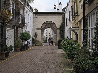
Hyde Park Gardens Mews is a mews street in the Bayswater area of London, W2. The mews consists of 46 residential properties, originally built as stables for Hyde Park Gardens, on a cobbled road with two entrances. The west entrance passes under an archway. The mews is entered by Clarendon Place at the west and Stanhope Terrace to the east. Sussex Place bisects the mews in the middle.

Mount Vernon House is a house in Hampstead in the London Borough of Camden. It has been listed Grade II on the National Heritage List for England (NHLE) since May 1974. The garden wall is separately listed at Grade II. The house was built around 1726 and was altered in the early 19th century. It is rendered in stucco with a mansard roof. The house occupies the site of a windmill. It was constructed between 1725 and 1728 by a local Hampstead timbersmith, William Knight.

Abernethy House at 7 Mount Vernon is a house in Hampstead in the London Borough of Camden. It has been listed Grade II on the National Heritage List for England (NHLE) since May 1974. It was originally built as a girls school around 1819. It is a 2-storey house with attics with a double front with 3 windows. A wooden door case surrounds the central entrance.

The Cottage, Charlton, Northamptonshire, England is a house of 18th century origins. In 1907 it was bought by F. E. Smith, 1st Earl of Birkenhead as his country home. Smith subsequently purchased another cottage on Main Street in Charlton and engaged Alan James to extend the house in 1911–12. James constructed a large central block to join the two cottages, and remodelled the grounds. Smith entertained at The Cottage throughout his legal and political careers, among his most frequent guests was Winston Churchill, his closest friend. Smith, ennobled as Viscount Furneaux, of Charlton in the County of Northampton, and Earl of Birkenhead in 1922, died of pneumonia caused by cirrhosis of the liver in 1930, aged 58. After cremation at Golders Green Crematorium, his ashes were brought to Charlton and interred in a tomb designed by Edwin Lutyens in the cemetery on Green Lane, just outside of the village. The Cottage remains a private residence and is a Grade II listed building.
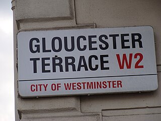
Gloucester Terrace is a street in Central London in the vicinity of Paddington and Bayswater. Located in the City of Westminster, it runs northwards from Lancaster Terrace near to Lancaster Gate tube station and Hyde Park before curving round to meet Porchester Square around Westbourne. The southern section is close to the border between Tyburnia and Bayswater. It intersects with Craven Road, Chilworth Street, Cleveland Terrace, Bishop's Bridge Road and Orsett Terrace. Its northern section is close to the Great Western Main Line and Westway. Westbourne Terrace runs directly parallel to the east.

Sussex Gardens is located in Paddington in Central London. It is a street that runs runs westwards from the Edgware Road, for most of the way as a broad avenue until it reaches an area near Lancaster Gate where it becomes a garden square. Part of the City of Westminster, it is located in the residential area of Tyburnia north of Hyde Park. Streets running off it include Westbourne Terrace, Talbot Square, London Street and Southwick Street. Sussex Gardens provides the main axis for the area.

Warrington Crescent is a street in Maida Vale in London. Located in the City of Westminster, it is a crescent curving north eastwards from Warwick Avenue until it reaches a roundabout where it meets including Randolph Avenue, Sutherland Avenue and Lauderdale Road. Warrington Gardens and Formosa Street both lead westwards off Warrington Crescent.

Norfolk Square is a rectangular garden square in Paddington in Central London. Located in the City of Westminster, it is part of the Tyburnia district north of Hyde Park. It runs east to west from London Street to Norfolk Place. Praed Street and Sussex Gardens are directly parallel to it north and south respectively.

Norland Square is a garden square in the Notting Hill area of London. Located in the Royal Borough of Kensington and Chelsea, runs northward from Holland Park Avenue to Queensdale Road. The mews street Norland Place runs eastwards of the Square.

Connaught Street is a street in Central London. Located in the City of Westminster, it is part of the Tyburnia area of Paddington north of Hyde Park. It runs west to east from Hyde Park Square to the Edgware Road. It continues eastwards becoming Upper Berkeley Street in Marylebone. The street contains a mixture of commercial and residential properties, forming part of Connaught Village. Connaught Square and Albion Street are located on its southern side. The Duke of Kendal public house sits at the junction between Connaught Street and Kendal Street.

Well Road is a street in Hampstead, England located in the London Borough of Camden. It runs westwards from Hampstead Heath to New End Square. Well Walk runs parallel to its south and the two are linked by Wells Passage. When the Hampstead Wells were in existence, a large pump room and assembly room were located on Well Walk, with the water supplied from the headspring on Well Road.