
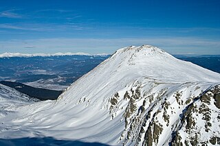
Kutelo is a summit in the Pirin mountain range, southwestern Bulgaria. With a height of 2,908 m it is the second highest peak in Pirin after Vihren (2,914 m), and the third one in Bulgaria, behind Musala (2,925 m) in Rila and Vihren. Kutelo is a double peak with a small saddle between the two parts, the lower being only one meter below the higher one, at 2,907 m. Seen from the town of Bansko it appears higher than Vihren.
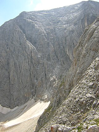
Golemiya Kazan is one of the two cirques that form an area called Kazanite, situated in Bulgaria's Pirin mountain range. Kazanite are located below the two highest summits Vihren (2,914 m) to the south and Kutelo (2,908 m) to the north. It is composed of two cirques, Malkiya Kazan, which is the lower one (2,200 m) and is grassy, and Golemiya Kazan, situated at 2,400 m and with stony slopes. The size of Golemiya Kazan is 1,200 m by 1,100 m. They were named like that because there is often fog rising from the cirques. Due to the karst in the region there are no lakes or streams in Kazanite. A 450 m-high face of Vihren begins from Golemiya Kazan and at its foot a small glacier called Snezhnika is located, whose size is 80x90 m in summer, with a latitude of 41°46′09″ N it is the southernmost glacial mass in Europe. Chamois are abundant in this area.

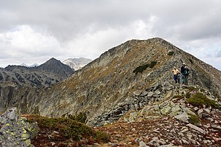
Polezhan (Bulgarian: Полежан [polɛˈʒan], known pre-1942 as Mangar Tepe is a 2,851 m cone shaped high peak in the Pirin mountain range, south-western Bulgaria. It is the highest granite summit in Pirin and the fourth highest in the mountain range after the marble peaks Vihren, Kutelo and Banski Suhodol.
Paril is a mountain saddle (pass) in western Bulgaria between the mountain ranges of Pirin to the north and Slavyanka to the south. It is situated on the territory of the Sandanski and Hadzhidimovo municipalities in Blagoevgrad Province.

Kamenitsa is a peak in the Pirin mountain range, south-western Bulgaria. It is located in the northern part of Pirin on the 22 km-long Kamenitsa secondary ridge between the summits of Malka Kamenitsa to the north and Yalovarnika (2,763 m) to the south. Its height is 2,822 m which ranks it on fifth place in Pirin, behind Vihren (2,914 m), Kutelo (2,908 m), Banski Suhodol (2,884 m) and Polezhan (2,851 m). The peak is built up of granite blocks covered in lichens.

Malak Polezhan is a peak in the northern section of the Pirin mountain range, south-western Bulgaria. Its height is 2,822 m which places it among the top ten summits of Pirin. The peak is built up of granite. Malak Polezhan is situated on the Polezhan side-ward ridge of the range between the peaks of Polezhan (2,851 m) to the north-east and Dzhengal (2,730 m) to the south.

Orelyak, also known as Orelek or Orlovi skali, is a peak in the Pirin mountain range, south-western Bulgaria. Reaching height of 2,099 m, it is the highest summit of Central Pirin, the second-highest subdivision of the mountain range. Orelayk is situated on Pirin's main ridge to the north of the Baba Peak and to the north-west of the Chala Peak. It has the shape of a triangular dome. The western slopes descend steeply, at places vertically, to the valley of the Pirinska Bistritsa river. Orelayk is built up of karstified marbles. Near its highest point is located a 96 m-high radio and television repeater. The lower part of the northern slopes falls within the territory of the Orelyak Reserve, created to protect the old growth beech forests of Central Pirin.
Yalovarnika is a 2,763 m-high peak in the Pirin mountain range, south-western Bulgaria. It is located in the northern part of Pirin on the 22 km-long Kamenitsa secondary ridge between the summits of Kamenitsa (2,822 m) to the north and Zabat (2,688 m), Kuklite (2,686 m) and Golena (2,633 m) to the south.

Momin Dvor is a 2,723 m high peak in the Pirin mountain range, south-western Bulgaria. It is located in the northern part of Pirin on its main ridge between the summits of Kralev Dvor (2,680 m) and Dzhengal (2,730 m). Momin Dvor is pyramid-shaped and was formed by glacial erosion from the three neighbouring cirques: Valyavishki, Popovski and Belemeto. It is built up of porphyry granite.
The Retizhe is a river in south-western Bulgaria, a right tributary of the Mesta. The river is 19 km long and drains parts of the eastern slopes of the Pirin mountain range.

Sivria is a 2,591 m high peak in the Pirin mountain range, south-western Bulgaria. It is located in the northern part of Pirin on the Dzhangalitsa ridge that stems from Pirin's main ridge at the summit of Dzhano (2,668 m). The eastern slopes descent to the Kremenski Lakes, while the northern and western slopes descent almost vertically to the Popovski cirque.
Dzhano is a 2,668 m high peak in the Pirin mountain range, south-western Bulgaria. It is located in the northern part of Pirin on the mountain's main ridge between Demirkapia Saddle and the summit of Chengelchal (2,709 m) in the south. From Dzhano the main ridge turns in southern direction. To the north the short secondary ridge Dzhangalitsa leads to the summit of Sivria (2,591 m). The north-eastern slopes descent to the Kremenski cirque and the homonymous lakes, to the east is the Kamenishki cirque and to the west — the Demirkapia one. Seen from Popovo Lake the summit appears imposing, though lower than the peaks along the main ridge further south. The peak is built up of porphyry granite blocks and is covered in moraines.

Chengelchal is a 2,709 m high peak in the Pirin mountain range, south-western Bulgaria. It is located in the northern part of Pirin on the mountain's main ridge to the south of the summit of Dzhano (2,668 m), with which it is linked via a narrow and rocky saddle known as Malkoto Konche.

Disilitsa is a 2,700 m high peak in the Pirin mountain range, south-western Bulgaria. It is located on the Polezhan secondary ridge at the end of a stem between Ushitsite and the summit of Kaymakchal (2,753 m) in the south. The slopes of Disilitsa are steep and rocky; they are covered in mountain pine at lower altitude. To the north there is a panoramic view towards the wooded slopes of the Yulen Nature Reserve and the Razlog Valley. To the north-west are located the two Perleshki Lakes and the cirque to the south-east hosts the Pleshivoto Lake, one of the highest in Pirin. The peak is built up of granite.

Ushite is a 1,978 m peak in the Pirin mountain range, south-western Bulgaria, making it the highest summit in South Pirin. It is situated on the main mountain ridge between the peaks of Sveshtnik (1,975 m) and Mutorok (1,971 m). Ushite is covered with forests. In Bulgarian its name means "the ears" and the etymology is linked with the presence of several rock piles on the summit likened to ears.

Kuklite is a 2,686 m-high peak in the Pirin mountain range, south-western Bulgaria. It is located in the northern part of Pirin on the Kamenitsa secondary ridge between the summits of Yalovarnika (2,763 m), Zabat (2,688 m) to the north-east and Golena (2,633 m) to the south. It is built up of granite. The western and north-western slopes of Kuklite are very steep and are open to the pebbly Begovitsa cirque; the foothills contain accumulations of moraines, densely covered in mountain pine at places. The eastern and south-eastern slopes facing the Bashmandra cirque are grassy and oblique. The Begovishko glacial lake is situated at the northern foothills of the summit.

Muratov Vrah is a 2,669 m high peak in the Pirin mountain range, south-western Bulgaria. It is situated on the main ridge of the mountain range, to the southwest of the summit of Hvoynati Vrah (2,635 m) and to the northwest of the rocky ridge Donchovi Karauli, from which it is separated by the saddle Banderishka porta. In southwestern direction from the summit branches the Sinanitsa secondary ridge of Pirin.

The Pirinska Bistritsa is a river in south-western Bulgaria, a left tributary of the Struma. The river is 53 km long; the last 7 km before its confluence with the Struma forms the border between Bulgaria and Greece. Pirinska Bistritsa drains the south-western sections of the Pirin mountain range and the northern sections of the Slavyanka mountain range.

Hvoynati Vrah is a 2,635 m high peak in the Pirin mountain range, south-western Bulgaria. It is situated on the main mountain ridge between the summits of Vihren (2,914 m) and Muratov Vrah (2,669 m). It is built up of granite.
Bezbog is a 2,645 m high granite peak in the Pirin mountain range, south-western Bulgaria. It is situated on the Polezhan secondary ridge on a branch that begins at the summit of Polezhan (2,851 m). The slopes in the direction of Polezhan are stony. To the east is located the Bezbog Cirque covered with dwarf mountain pine that hosts the Bezbozhko Lake where there is a trail leading to the Popovo Lake, the largest glacial lake in Pirin. To the north of Bezbog begins a short ridge with grassy and stony slopes in the higher parts and a thick dwarf mountain pine cover that leads to the summit of Bezbozhka Tumba (2,263 m). The western slopes of Bezbog towards the Polezhan Cirque are rocky and very steep, in some places vertical.
