Related Research Articles
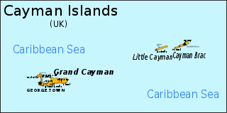
The Cayman Islands are a British dependency and island country. It is a three-island archipelago in the Caribbean Sea, consisting of Grand Cayman, Cayman Brac, and Little Cayman. Georgetown, the capital of the Cayman Islands is 438 km (272 mi) south of Havana, Cuba, and 504 km (313 mi) northwest of Kingston, Jamaica, northeast of Costa Rica, north of Panama and are between Cuba and Central America. Georgetown's geographic coordinates are 19.300° north, 81.383° west.

The North American Plate is a tectonic plate covering most of North America, Cuba, the Bahamas, extreme northeastern Asia, and parts of Iceland and the Azores. With an area of 76 million km2 (29 million sq mi), it is the Earth's second largest tectonic plate, behind the Pacific Plate.

The Cocos Plate is a young oceanic tectonic plate beneath the Pacific Ocean off the west coast of Central America, named for Cocos Island, which rides upon it. The Cocos Plate was created approximately 23 million years ago when the Farallon Plate broke into two pieces, which also created the Nazca Plate. The Cocos Plate also broke into two pieces, creating the small Rivera Plate. The Cocos Plate is bounded by several different plates. To the northeast it is bounded by the North American Plate and the Caribbean Plate. To the west it is bounded by the Pacific Plate and to the south by the Nazca Plate.

The Caribbean Plate is a mostly oceanic tectonic plate underlying Central America and the Caribbean Sea off the northern coast of South America.

The Geology of Puerto Rico "can be divided into three major geologic provinces: The Cordillera Central, the Carbonate, and the Coastal Lowlands." Puerto Rico is composed of Jurassic to Eocene volcanic and plutonic rocks, which are overlain by younger Oligocene to recent carbonates and other sedimentary rocks. Most of the caverns and karst topography on the island occurs in the northern Oligocene to recent carbonates. The oldest rocks are approximately 190 million years old (Jurassic) and are located at Sierra Bermeja in the southwest part of the island. These rocks may represent part of the oceanic crust and are believed to come from the Pacific Ocean realm.
Easter Plate is a tectonic microplate located to the west of Easter Island off the west coast of South America in the middle of the Pacific Ocean, bordering the Nazca Plate to the east and the Pacific Plate to the west. It was discovered from looking at earthquake distributions that were offset from the previously perceived Nazca-Pacific Divergent boundary. This young plate is 5.25 million years old and is considered a microplate because it is small with an area of approximately 160,000 square kilometres (62,000 sq mi). Seafloor spreading along the Easter microplate's borders have some of the highest global rates, ranging from 50 to 140 millimetres /yr.

The 1,600 kilometres (990 mi) long Macquarie Fault Zone is a major right lateral-moving transform fault along the seafloor of the south Pacific Ocean which runs from New Zealand southwestward towards the Macquarie Triple Junction. It is also the tectonic plate boundary between the Australian Plate to the northwest and the Pacific Plate to the southeast. As such it is a region of high seismic activity and recorded the largest strike-slip event on record up to May 23, 1989, of at least Mw8.0

The Motagua Fault is a major, active left lateral-moving transform fault which cuts across Guatemala. It forms part of the tectonic boundary between the North American Plate and the Caribbean Plate. It is considered the onshore continuation of the Swan Islands Transform Fault and Cayman trench, which run under the Caribbean Sea. Its western end appears not to continue further than its surface trace, where it is covered by Cenozoic volcanics.
The 2009 Swan Islands earthquake occurred on May 28 at 02:24:45 AM local time with a moment magnitude of 7.3 and a maximum Mercalli intensity of VII. The epicenter was located in the Caribbean Sea, 64 kilometres (40 mi) northeast of the island of Roatán, 19 miles northeast of Port Royal, Isla de Bahias, 15 miles northwest of Isla Barbaretta, and 130 kilometres (81 mi) north-northeast of La Ceiba. Three aftershocks followed the earthquake within magnitude 4 range.
The 1692 Jamaica earthquake struck Port Royal, Jamaica, on 7 June. A stopped pocket watch found in the harbor during a 1959 excavation indicated that it occurred around 11:43 AM local time.

The Enriquillo–Plantain Garden fault zone is a system of active coaxial left lateral-moving strike slip faults which runs along the southern side of the island of Hispaniola, where Haiti and the Dominican Republic are located. The EPGFZ is named for Lake Enriquillo in the Dominican Republic where the fault zone emerges, and extends across the southern portion of Hispaniola through the Caribbean to the region of the Plantain Garden River in Jamaica.
The Septentrional-Orient fault zone (SOFZ) is a system of active coaxial left lateral-moving strike slip faults that runs along the northern side of the island of Hispaniola where Haiti and the Dominican Republic are located and continues along the south of Cuba along the northern margin of the Cayman Trough. The SOFZ shares approximately half of the relative motion between the North American and Caribbean tectonic plates with the Enriquillo-Plantain Garden fault zone and Walton fault zone which run along the southern side of Hispaniola and aong the southern margin of the Cayman Trough. Both fault zones terminate at the Mid-Cayman Rise to the west. Some researchers believe that the Enriquillo-Plantain Garden fault zone and the SOFZ bound a microplate, dubbed the Gonâve Microplate, a 190,000 km2 (73,000 sq mi) area of the northern Caribbean Plate that is in the process of shearing off the Caribbean Plate and accreting to the North America Plate.
The Gonâve Microplate forms part of the boundary between the North American Plate and the Caribbean Plate. It is bounded to the west by the Mid-Cayman Rise spreading center, to the north by the Septentrional-Oriente fault zone and to the south by the Walton fault zone and the Enriquillo–Plantain Garden fault zone. The existence of this microplate was first proposed in 1991. This has been confirmed by GPS measurements, which show that the overall displacement between the two main plates is split almost equally between the transform fault zones that bound the Gonâve microplate. The microplate is expected to eventually become accreted to the North American Plate.

On 9 January 2018, at approximately 8:51 p.m. local time, a magnitude 7.5 earthquake struck in the Yucatán Basin of the Caribbean Sea, 44 kilometres (27 mi) east of Great Swan Island off the coast of Honduras. The earthquake was felt across Central America, and rattled windows in Tegucigalpa. The earthquake was also felt in the Cayman Islands.
The Walton fault zone is a major active left lateral (sinistral) strike-slip fault, forming part of the southern boundary to the Cayman Trough. It extends from the Mid-Cayman Rise spreading center in the west to Jamaica in the east. It has a total length of about 360 km and is formed of several sub-parallel strands. Together with the Enriquillo-Plantain Garden fault zone it forms the southern boundary of the Gonâve Microplate. It is associated with only moderate earthquakes with magnitudes of less than 6.
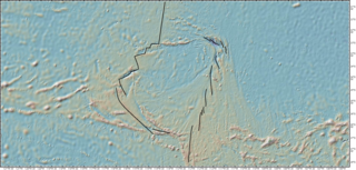
The Mid-Cayman Rise or Mid-Cayman Spreading Center is a relatively short divergent plate boundary in the middle of the Cayman Trough. It forms part of a dominantly transform boundary that is part of the southern margin to the North American Plate. It is an ultra-slow spreading center with an opening rate of 15–17 mm per year.
The Cayman Ridge is an undersea mountain range on the northern margin of the Cayman Trough in the Caribbean Sea. It extends from the Sierra Maestra in the east to the Misteriosa Bank in the west, a distance of about 1,500 km (930 mi). The Cayman Ridge also includes the Cayman Islands.

At 2:10 p.m. local time (UTC-5) on 28 January 2020, an earthquake of 7.7 Mw struck on the north side of the Cayman Trough, north of Jamaica and west of the southern tip of Cuba, with the epicenter being 80 miles (130 km) ESE of Cayman Brac, Cayman Islands or 83 miles (134 km) north of Montego Bay, Jamaica. Schools in Jamaica and buildings in Miami were evacuated after shaking was observed in parts of the U.S. state of Florida. Light shaking was also reported on the Yucatan peninsula in Mexico. It is the largest earthquake in the Caribbean since 1946. A tsunami warning for the Caribbean Sea was issued by the Pacific Tsunami Warning Center and later withdrawn.
References
- ↑ Rosencrantz M.; Mann P. (1991). "SeaMARC II mapping of transform faults in the Cayman Trough, Caribbean Sea". Geology. 19 (7): 690–691. Bibcode:1991Geo....19..690R. doi:10.1130/0091-7613(1991)019<0690:SIMOTF>2.3.CO;2.
- ↑ "M7.6 - 44km E of Great Swan Island, Honduras". Earthquake Hazards Program. U.S. Geological Survey.
| | This article about structural geology is a stub. You can help Wikipedia by expanding it. |
| | This Honduras-related article is a stub. You can help Wikipedia by expanding it. |