
At 824,292 km2 (318,261 sq mi), Namibia is the world's thirty-fourth largest country. After Mongolia, Namibia is the second least densely populated country in the world. Namibia got its name from the Namib desert that stretches along the coast of the Atlantic. It is also known for its wildlife.

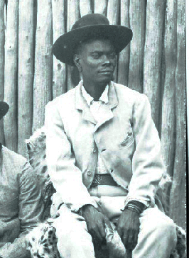
The Himba are an indigenous people with an estimated population of about 50,000 people living in northern Namibia, in the Kunene Region and on the other side of the Kunene River in southern Angola. There are also a few groups left of the OvaTwa, who are also OvaHimba, but are hunter-gatherers. Culturally distinguishable from the Herero people, the OvaHimba are a semi-nomadic, pastoralist people and speak OtjiHimba, a variety of Herero, which belongs to the Bantu family within Niger–Congo. The OvaHimba are semi-nomadic as they have base homesteads where crops are cultivated, but may have to move within the year depending on rainfall and where there is access to water.
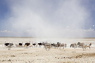
Etosha National Park is a national park in northwestern Namibia and one of the largest national parks in Africa. It was proclaimed a game reserve in March 1907 in Ordinance 88 by the Governor of German South West Africa, Friedrich von Lindequist. It was designated as Wildschutzgebiet in 1958, and was awarded the status of national park in 1967 by an act of parliament of the Republic of South Africa. It spans an area of 22,270 km2 (8,600 sq mi) and was named after the large Etosha pan which is almost entirely within the park. With an area of 4,760 km2 (1,840 sq mi), the Etosha pan covers 23% of the total area of the national park. The area is home to hundreds of species of mammals, birds and reptiles, including several threatened and endangered species such as the black rhinoceros. Sixty-one black rhinoceros were killed during poaching in Namibia during 2022, 46 of which were killed in Etosha.

Kunene is one of the fourteen regions of Namibia. Its capital is Opuwo, its governor is Marius Sheya. The region's name comes from the Kunene River which forms the northern border with Angola. Besides the capital Opuwo, the region contains the municipality of Outjo, the town Khorixas and the self-governed village Kamanjab. Kunene is home to the Himba people, a subtribe of the Herero. As of 2020, Kunene had 58,548 registered voters.

The Cunene or Kunene is a river in Southern Africa. It flows from the Angola highlands southwards to the border with Namibia. It then flows in a westerly direction along the border until it reaches the Atlantic Ocean. It is one of the few perennial rivers in the region. It is about 1,050 kilometres (652 mi) long, with a drainage basin 106,560 square kilometres (41,143 sq mi) in area. Its mean annual discharge is 174 m3/s at its mouth. The Epupa Falls lie on the river. Olushandja Dam dams a tributary of the river, the Etaka, and helps to provide the Ruacana Power Station with water.
Kaokoland was an administrative unit and a bantustan in northern South West Africa. Established in 1980 during the apartheid era, it was intended to be a self-governing homeland of the Ovahimba, but an actual government was never established, and the territory was administered by the leaders of Hereroland. Like other homelands in South West Africa, the Kaokoland bantustan was abolished in May 1989, at the beginning of the transition of Namibia towards independence.

Ruacana is a town in the Omusati Region of northern Namibia and the district capital of the Ruacana electoral constituency. It is located on the border with Angola on the river Kunene. The town is known for the picturesque Ruacana Falls nearby, and for the Ruacana Power Station.

Outjo is a town of 6,000 inhabitants in the Kunene Region of Namibia. It is the district capital of Outjo Constituency. It is best known as the main gateway to Etosha National Park.

Opuwo is the capital of the Kunene Region in north-western Namibia. The town is situated about 720 km north-northwest from the capital Windhoek, and has a population of 20,000. It is the commercial hub of the Kunene Region.
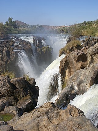
Epupa Falls is a series of large waterfalls formed by the Cunene River on the border of Angola and Namibia, in the Kaokoland area of the Kunene Region. The river is about 0.5 kilometres (1,600 ft) wide in this area and drops in a series of waterfalls across a length of 1.5 kilometres (0.93 mi), with the greatest single drop being 37 metres (121 ft) in height. The settlement near the falls is also called Epupa.
Articles related to Namibia include:

Sesriem is a small settlement in the Namib Desert, in the Hardap Region of Namibia, close to the southern end of the Naukluft Mountains. It is especially known because the "Sesriem gate" is the main access point to the Namib-Naukluft National Park for visitors entering the park to visit the nearby tourist attraction of Sossusvlei. As many "settlements" in the Namib, Sesriem is essentially a filling station with basic services such as public telephones and a couple of small kiosks where travellers can get general supplies such as food and water. In the surroundings of Sesriem there are several accommodation establishments, such as a few lodges and 24 campsites.

Dorsland Trek is the collective name of a series of explorations undertaken by Boer settlers from South Africa from 1874 to 1881, in search of political independence and better living conditions. The participants, Trekboers from the Orange Free State and Transvaal, are called Dorslandtrekkers.
Andreas Lambert, also known as Andries Lambert, was the second Kaptein of the Kaiǀkhauan, a subtribe of the Orlam, in the eastern area of South-West Africa, today's Namibia.

Leonardville is a village in eastern Namibia, situated on the Nossob River in the south-western corner of Omaheke Region. It belongs to the Aminuis electoral constituency.

Hermanus van Wyk (1835–1905) was the first Kaptein of the Baster community at Rehoboth in South-West Africa, today Namibia. Under his leadership, the mixed-race Basters moved from the Northern Cape to leave white racial discrimination, and migrated into the interior of what is now central Namibia; the first 30 families settled about 1870. They acquired land from local natives and were joined by additional Baster families over the following years. The Baster people developed their own constitution, called the Paternal Laws. They relied on the herding of sheep, goats and cattle as the basis of their economy.
Nehale lya Mpingana was Omukwaniilwa of Ondonga, a subtribe of the Owambo, in German South West Africa. Their tribal area is situated around Namutoni on the eastern edge of Etosha pan in today's northern Namibia. He reigned over the eastern part of the Ondonga area from 1884 until his death; Kambonde II kaMpingana was chief of the western part.

Lijdensrust, officially the Republic of Lijdensrust, was a short-lived Boer republic in the area of present-day Namibia. Declared on 20 October 1885, it was originally named Upingtonia, but changed its name soon after as the reason for its original name proved worthless. In 1887, it was merged into German South-West Africa.
The Reformed Churches in Namibia is a confessional Reformed church in Namibia. Reformed people come from Angola to Namibia in 1929. The Dorslandtrekkers were mostly Reformed people who had settled in Angola but later moved to Namibia. The Dorslandtrekkers were originally from Transvaal, South Africa, and migrated northwestward starting in 1874 in two large and one smaller group, starting the Humpata Reformed Church under the Rev. Jan Lion Cachet. Later in 1930 3 congregations were established. More farmers came and the church grew. Missionary work was started in 1969 under the Bushmans of the Gobabis region, Botswana. It has 2,757 members and 14 congregations, and adheres to the Apostles Creed, Nicene Creed, Heidelberg Catechism, Belgic Confession and the Canons of Dort.There's no women ordination. Official languages are Afrikaans, Bushman, Gobabis-Kung.

Gert Andries Jacobus Alberts was the leader of the First Dorsland Trek. He was a member of the Gereformeerde Kerk and served as a church elder (‘kerkraadslid’).

