
The European route E 22 is one of the longest European routes. It has a length of about 5,320 km (3,310 mi). Many of the E-roads have been extended into Asia since the year 2000; the E 22 was extended on 24 June 2002.

CKSA-FM is a Canadian radio station broadcasting at 95.9 FM in Lloydminster. The station currently plays a country music format, with the on-air moniker Real Country 95.9 and was owned by Newcap Radio until they were bought out by Stingray Digital.
North Thompson Oxbows Jensen Island Provincial Park is a provincial park in British Columbia, Canada. It is an oxbow feature in the North Thompson River lowlands. There is no camping or day-use facilities provided there.

Fukuro-machi is a Hiroden station on Hiroden Ujina Line located in Ote-machi 2-chome, Naka-ku, Hiroshima.
Brynrefail is a small village in north-east Anglesey, Wales.
Elias Soplin Vargas District is one of nine districts of the province Rioja in Peru.
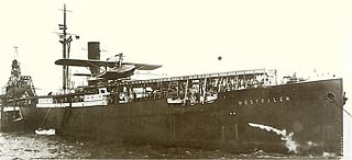
SS Westfalen was a German ship launched on 14 November 1905 at Joh. C. Tecklenborg in Geestemünde.
Jastrzygowice is a village in the administrative district of Gmina Gorzów Śląski, within Olesno County, Opole Voivodeship, in south-western Poland.
Spławie is a village in the administrative district of Gmina Chociwel, within Stargard County, West Pomeranian Voivodeship, in north-western Poland.
Kenyon is a village in the civil parish of Croft in Warrington, Cheshire, England.
The Open Publication Distribution System (OPDS) catalog format is a syndication format for electronic publications based on Atom and HTTP. OPDS catalogs enable the aggregation, distribution, discovery, and acquisition of electronic publications. OPDS catalogs use existing or emergent open standards and conventions, with a priority on simplicity.
Pähkla is a village in Saaremaa Parish, Saare County in western Estonia.
Belcher is one of the 15 constituencies in the Central and Western District of Hong Kong.
Boulélaye is a settlement in Senegal.
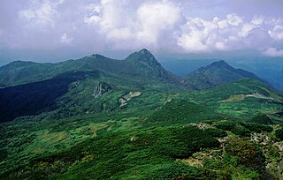
Furano-Ashibetsu Prefectural Natural Park is a Prefectural Natural Park in central Hokkaidō, Japan. Established as a Prefectural Park in 1955 and redesignated a Prefectural Natural Park in 1958, the park spans the municipalities of Ashibetsu, Furano, Mikasa, Minamifurano, and Yūbari.

Schellman loops are commonly occurring structural features of proteins and polypeptides. Each has six amino acid residues with two specific inter-mainchain hydrogen bonds and a characteristic main chain dihedral angle conformation. The CO group of residue i is hydrogen-bonded to the NH of residue i+5, and the CO group of residue i+1 is hydrogen-bonded to the NH of residue i+4. Residues i+1, i+2, and i+3 have negative φ (phi) angle values and the phi value of residue i+4 is positive. Schellman loops incorporate a three amino acid residue RL nest, in which three mainchain NH groups form a concavity for hydrogen bonding to carbonyl oxygens. About 2.5% of amino acids in proteins belong to Schellman loops. Two websites are available for examining small motifs in proteins, Motivated Proteins: ; or PDBeMotif:.
Canbazlı is a village in Alaplı District, Zonguldak Province, Turkey.
Deerfield Township is a township in Vernon County, in the U.S. state of Missouri.

Raynagar is a town in Jaynagar I CD Block of South 24 Parganas district in the Indian State of West Bengal. Jaynagar police station serves this town.
Hogla is a village in Jaynagar I CD Block of South 24 Parganas district in the Indian State of West Bengal. Jaynagar police station serves this village.


