The geography of Mexico describes the geographic features of Mexico, a country in the Americas. Mexico is located at about 23° N and 102° W in the southern portion of North America. From its farthest land points, Mexico is a little over 3,200 km (2,000 mi) in length. Mexico is bounded to the north by the United States, to the west and south by the Pacific Ocean, to the east by the Gulf of Mexico, and to the southeast by Belize, Guatemala, and the Caribbean Sea. The northernmost constituent of Latin America, it is the most populous Spanish-speaking country in the world. Mexico is the world's 13th largest country, three times the size of Texas.

Ciudad del Carmen is a city in the southwest of the Mexican state of Campeche. Ciudad del Carmen is located at 18.63°N 91.83°W on the southwest of Carmen Island, which stands in the Laguna de Términos on the coast of the Gulf of Mexico. As of 2010, Ciudad del Carmen had a population of 169,466, up from the 2005 census of 154,197. In July 2006, Ciudad del Carmen celebrated its 150th anniversary as a city.
Tabasco, officially the Free and Sovereign State of Tabasco, is one of the 32 Federal Entities of Mexico. It is divided into 17 municipalities and its capital city is Villahermosa.

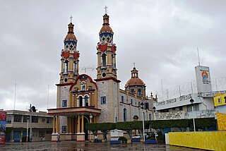
Villahermosa is the capital and largest city of the Mexican state of Tabasco, and serves as the municipal seat of the state. Located in Southeast Mexico, Villahermosa is an important city because of its cultural history, natural resources, commercial development, and modern industrialization.

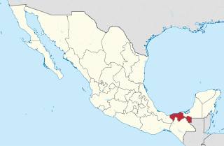
Campeche, officially the Free and Sovereign State of Campeche, is one of the 31 states which make up the 32 Federal Entities of Mexico. Located in southeast Mexico, it is bordered by the states of Tabasco to the southwest, Yucatán to the northeast, and Quintana Roo to the east; to the southeast by the Orange Walk district of Belize, and by the Petén department of Guatemala to the south. It has a coastline to the west with the Gulf of Mexico. The state capital, also called Campeche, was declared a World Heritage Site in 1997. The formation of the state began with the city, which was founded in 1540 as the Spanish began the conquest of the Yucatán Peninsula. The city was a rich and important port during the colonial period, but it declined after Mexico's independence. Campeche was part of the province of Yucatán but split off in the mid-19th century, mostly due to political friction with the city of Mérida. Much of the state's recent economic revival is due to the discovery of petroleum offshore in the 1970s, which has made the coastal cities of Campeche and Ciudad del Carmen important economic centers. The state has important Mayan and colonial sites; however, these are not as well-known or visited as others in the Yucatán.

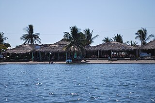
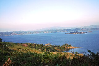
Laguna de Términos is the largest tidal lagoon by volume located entirely on the Gulf of Mexico, as well as one of the most biodiverse. Exchanging water with several rivers and lagoons, the Laguna is part of the most important hydrographic river basin in Mexico. It is important commercially, as well as ecologically by serving as a refuge for an extensive number of flora and fauna; its mangroves provide an important role as a refuge for migratory birds.
The Chontal Maya are a Maya people of the Mexican state of Tabasco. "Chontal", from the Nahuatl word for chontalli, which means "foreigner", has been applied to various ethnic groups in Mexico. The Chontal refer to themselves as the Yokot'anob or the Yokot'an, meaning "the speakers of Yoko ochoco", but writers about them refer to them as the Chontal of Centla, the Tabasco Chontal, or in Spanish, Chontales. They consider themselves the descendants of the Olmecs, and are not related to the Oaxacan Chontal.

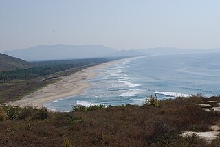
Tecolutla is a town and municipality located on the Tecolutla River on the eastern coast of the state of Veracruz in Mexico. It has the closest beaches to Mexico City, and much of its economy is based on tourism, as it is only a four- or five-hour drive from the capital. It is the northern end of a tourist corridor along the Gulf of Mexico called the "Emerald Coast," which extends down to the city of Veracruz.

The 2007 Tabasco flood occurred in late October and early November 2007 in the Mexican states of Tabasco and Chiapas, in which as much as 80% of the former was left under water. At least 20,000 people were forced to seek emergency shelter. Over 1,000,000 residents were affected.
Boca de Cielo is a small fishing town and beach in the municipality of Tonalá, Chiapas, Mexico. It and Puerto Arista, fifteen km away, are the two best known beaches on the Chiapas coast. Boca de Cielo is part of Chiapas’ Istmus-Costa Region on the north coast. it is one of many beaches in the region that stretch uninterrupted by anything except estuaries and lagoons formed by the small rivers that run from the nearby Sierra Madre de Chiapas mountains to the Pacific Ocean. The climate is semi moist with rain mostly in the summer and an average annual temperature of 27C, with weather is hottest in the spring and summer. The area around Boca del Cielo is filled with pastures for cattle as this is the main economic activity of the northern coast region.

The Costa Chica of Guerrero is an area along the south coast of the state of Guerrero, Mexico, extending from just south of Acapulco to the Oaxaca border. Geographically, it consists of part of the Sierra Madre del Sur, a strip of rolling hills that lowers to coastal plains to the Pacific Ocean. Various rivers here form large estuaries and lagoons that host various species of commercial fish.
Costa Grande of Guerrero is a sociopolitical region located in the Mexican state of Guerrero, along the Pacific Coast. It makes up 325 km (202 mi) of Guerrero's approximately 500 km (311 mi) coastline, extending from the Michoacán border to the Acapulco area, wedged between the Sierra Madre del Sur and the Pacific Ocean. Acapulco is often considered part of the Costa Grande; however, the government of the state classifies the area around the city as a separate region. The Costa Grande roughly correlates to the Cihuatlán province of the Aztec Empire, which was conquered between 1497 and 1504. Before then, much of the area belonged to a dominion under the control of the Cuitlatecs, but efforts by both the Purépecha Empire and Aztec Empire to expand into this area in the 15th century brought this to an end. Before the colonial period, the area had always been sparsely populated with widely dispersed settlements. The arrival of the Aztecs caused many to flee and the later arrival of the Spanish had the same effect. For this reason, there are few archeological remains; however, recent work especially at La Soledad de Maciel has indicated that the cultures here are more important than previously thought. Today, the area economically is heavily dependent on agriculture, livestock, fishing and forestry, with only Zihuatanejo and Ixtapa with significantly developed infrastructure for tourism. The rest of the coast has been developed spottily, despite some government efforts to promote the area.

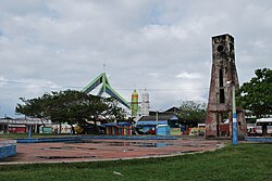
Reforma is a city and one of the 119 Municipalities of Chiapas, in southern Mexico.

Catemaco Municipality is one of the 212 municipalities that make up the Mexican state of Veracruz. It is in the state's Los Tuxtlas. The municipal seat is the city of Catemaco.
Paraíso is a town and municipality located in the north of the Mexican state of Tabasco, about 75 km due north of the state capital of Villahermosa on the Gulf of Mexico. Much of the area is traditionally dedicated to fishing and agriculture. Today, it is also an oil-producing area with the mostly oil-dedicated port of Dos Bocas. There is also some tourism connected to the area's beaches and natural attractions, and the area is promoted under the state's Cacao Route tourism program.

Pahuatlán, officially Pahuatlán del Valle, is a town and municipality located in the northwest of the state of Puebla in central Mexico. The municipality is part of the Sierra Norte region of the state, a steep mountainous area which receive significant moisture from the Gulf of Mexico, and borders the states of Hidalgo and Veracruz.
The Malpaso Dam, officially known as the Nezahualcóyotl Dam, is located in the Centro region of Chiapas, Mexico near the border with Tabasco and Veracruz. It was the first of several major dams built on the Grijalva River to generate hydroelectric energy and has the second largest reservoir in Mexico, after the Belisario Dominguez Dam. Construction of the dam occurred in the 1960s and flooded not only the riverbed but also hectares of rainforest and farmland, various towns and villages and archeological sites. These include the former town of Quechula, whose 16th century Dominican church will appear when water is at low levels, and the archeological site of San Isidro which contains one of only two known double Mesoamerican ball courts. Commissioning of the dam's 1,080 MW power station began in 1969 and ended in 1977. The reservoir and later construction of a federal highway has spurred ecotourism in the area.

Jalpa de Méndez is a city in Jalpa de Méndez Municipality located in the north of the state of Tabasco, Mexico. It is considered part of the Chontal Maya region of the state, known for its production of decorated dried gourds traditionally used for drinking chocolate and cured meats. Although there is some oil production and tourism, its main economic activity is agriculture, producing cacao, coconut and livestock.

Puerto Arista is a small community and tourist attraction located on the north coast of Chiapas, Mexico in the municipality of Tonalá. While it originally was a port, its lack of harbor and suitability for large cargo ships eventually shifted the economy to tourism in the 20th century. It is popular with people from Chiapas as it is located close to the state capital of Tuxtla Gutiérrez as well as the regional city of Tonalá. It is the most visited beach in Chiapas and one of its most popular tourist destinations, despite its relative lack of sophisticated tourism infrastructure. Puerto Arista is home of one of the state’s four marine turtle sanctuaries, design to help protect the various species which come here to lay their eggs.
Chontalpa is an area in the Mexican state of Tabasco, which consists of four municipalities in the northwest of the state. Although the name refers to the state's Chontal Maya population, modern Chontalpa is a subregion of the Grijalva Region, and formed with economic concerns in mind. A large percentage of the state's Chontal Maya population does live here, with the municipality of Nacajuca having the largest concentration of indigenous, with the next largest concentration found just east of the region in the Villahermosa area. The subregion's economy is based on agriculture, especially livestock production as well as oil drilling, which have been at odds with each other because of severe degradation of the environment since the mid 20th century. Chontalpa is also home to Tabasco's two main archeological sites, La Venta and Comalcalco, along with numerous smaller sites.