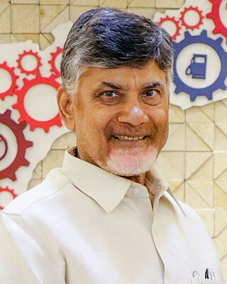
Nara Chandrababu Naidu, also known as Chandrababu Naidu or CBN, is an Indian politician and the current leader of the opposition in the Andhra Pradesh Legislative Assembly. He also served as Chief Minister from 1995 to 2004 and as opposition leader from 2004 to 2014 of Andhra Pradesh. He has been the president of the Telugu Desam Party (TDP) since 1995.
Naidu is a native Telugu surname commonly used by some Telugu castes. 'Nayudu/Naidu' (నాయుడు) is a contraction of the Telugu word 'Nayakudu' (నాయకుడు) meaning leader, chief, headman. Telugu castes such as the Balija,Kapu/Telaga, Kamma, Gavara, Golla, Mudiraju, Turpu Kapu, Velama and Boya use the title.

The Telugu Desam Party is an Indian regional political party with great influence in the states of Andhra Pradesh and Telangana. It was founded by the former chief minister of Andhra Pradesh N. T. Rama Rao (N.T.R.) on 29 March 1982 and has focused on supporting Telugu speakers. The party has won a five-time majority in the Andhra Pradesh Legislative Assembly and has emerged as the most successful political outfit in the state's history. It is currently the main opposition party in the Andhra Pradesh Legislative Assembly.
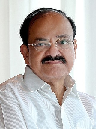
Muppavarapu Venkaiah Naidu is an Indian politician who served as the 13th vice president of India from 2017 to 2022. He is the first Indian vice president born in independent India. He has also served as the minister of Housing and Urban Poverty Alleviation, Urban Development and Information and Broadcasting in the Modi Cabinet.

Buchireddypalem is a town in the Nellore district of India. It is the Buchireddypalem Nagar panchayat part of the Kovur Located 15 km from Nellore city, it is located on the state highway connecting Nellore and Mumbai.... The nearest railway station is Nellore railway station, the nearest seaport is Krishnapatnam and the nearest airports are Tirupati and Chennai and in near future there will be a Nellore Airport.
Kapu is a Hindu caste mainly found in the Indian state of Andhra Pradesh. They are classified as a Forward caste. They are a community of land-owning agriculturists. Historically, they have also been warriors and military generals (Nayakas) in Hindu armies. They are a dominant caste of Andhra Pradesh. Kapus commonly carry the title Naidu. They are primarily present in Coastal Andhra with major concentration in the Godavari-Krishna delta region.
Telaga is a community found in Coastal Andhra region of India. Telaga is a subcaste of Kapu and both terms are often used synonymously. They are classified as a Forward caste. They are a land-owning agrarian community. Historically, they were a warrior caste known for their honour and bravery.

Parawada is a mandal in Anakapalli district in the state of Andhra Pradesh in India.
Kālingi is a Hindu caste residing in the Indian states of Andhra Pradesh and Odisha. In Andhra, they are primarily found in the erstwhile Srikakulam district with smaller numbers in neighbouring districts. They are predominantly a caste of cultivators. Some of the community members also served as temple priests in the past. They are categorized as an Other Backward Classes (OBC) by the Government of Andhra Pradesh.
Muthukur or Muttukuru is a village and a Mandal in Nellore district in the state of Andhra Pradesh in India.
Venkata Raju Palem is a village in Maddipadu mandal, Prakasam district, Andhara Pradesh state in India.
P. Naidu Palem is a village in Chimakurthi mandal, located in Prakasam district of Andhra Pradesh, India.
Kovur is a village in Kandukur Mandal of Prakasam district, in the State of Andhra Pradesh, India. It is one of the large tobacco farming villages in the Kandukur region.
Kotha Palem is a model village situated one kilometer from Tallur in Prakasam district, in the state of Andhra Pradesh, India.
Basireddy Palem is a village in Prakasam district of the Indian state of Andhra Pradesh. It is located in Gudluru mandal of Kandukur revenue division.

Pothinamallayya Palem or PM Palem, is a residential neighbourhood situated in Visakhapatnam city in the Indian state of Andhra Pradesh. It is located in the Greater Visakhapatnam Municipal Corporation area. It is located to the north of Visakhapatnam city on National Highway 16 (NH16) to Srikakulam. This place is well connected to other parts of the city such as Asilmetta and Maddilapalem. The only international cricket stadium in Andhra Pradesh is located here.
Lingareddypalem, also Lingareddy Palem, is a village in Krishna District of Andhra Pradesh, India. It is located in the Koduru Mandal at a distance of 110 km from Vijayawada and 50 km from Machilipatnam. The Postal Index (PIN) is 521328.

