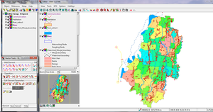
A geographic information system (GIS) consists of integrated computer hardware and software that store, manage, analyze, edit, output, and visualize geographic data. Much of this often happens within a spatial database, however, this is not essential to meet the definition of a GIS. In a broader sense, one may consider such a system also to include human users and support staff, procedures and workflows, the body of knowledge of relevant concepts and methods, and institutional organizations.

Esri is an American multinational geographic information system (GIS) software company. It is best known for its ArcGIS products. With a 43% market share, Esri is the world's leading supplier of GIS software, web GIS and geodatabase management applications. The company is headquartered in Redlands, California.
A GIS file format is a standard for encoding geographical information into a computer file, as a specialized type of file format for use in geographic information systems (GIS) and other geospatial applications. Since the 1970s, dozens of formats have been created based on various data models for various purposes. They have been created by government mapping agencies, GIS software vendors, standards bodies such as the Open Geospatial Consortium, informal user communities, and even individual developers.
A GIS software program is a computer program to support the use of a geographic information system, providing the ability to create, store, manage, query, analyze, and visualize geographic data, that is, data representing phenomena for which location is important. The GIS software industry encompasses a broad range of commercial and open-source products that provide some or all of these capabilities within various information technology architectures.
A Web Map Service (WMS) is a standard protocol developed by the Open Geospatial Consortium in 1999 for serving georeferenced map images over the Internet. These images are typically produced by a map server from data provided by a GIS database.

ArcGIS is a family of client, server and online geographic information system (GIS) software developed and maintained by Esri. ArcGIS was first released in 1999 and originally was released as ARC/INFO, a command line based GIS system for manipulating data. ARC/INFO was later merged into ArcGIS Desktop, which was eventually superseded by ArcGIS Pro in 2015. ArcGIS Pro works in 2D and 3D for cartography and visualization, and includes artificial Intelligence (AI).
ArcInfo is a full-featured geographic information system produced by Esri, and is the highest level of licensing in the ArcGIS Desktop product line. It was originally a command-line based system. The command-line processing abilities are now available through the GUI of the ArcGIS Desktop product.

ArchiCAD is an architectural BIM CAD software for Mac and Windows developed by the Hungarian company Graphisoft. ArchiCAD offers computer aided solutions for handling all common aspects of aesthetics and engineering during the whole design process of the built environment—buildings, interiors, urban areas, etc.

QGIS is a free and open-source cross-platform desktop geographic information system (GIS) application that supports viewing, editing, printing, and analysis of geospatial data.

The Geospatial Data Abstraction Library (GDAL) is a computer software library for reading and writing raster and vector geospatial data formats, and is released under the permissive X/MIT style free software license by the Open Source Geospatial Foundation. As a library, it presents a single abstract data model to the calling application for all supported formats. It may also be built with a variety of useful command line interface utilities for data translation and processing. Projections and transformations are supported by the PROJ library.
JTS Topology Suite is an open-source Java software library that provides an object model for Euclidean planar linear geometry together with a set of fundamental geometric functions. JTS is primarily intended to be used as a core component of vector-based geomatics software such as geographical information systems. It can also be used as a general-purpose library providing algorithms in computational geometry.
MapInfo Pro is a desktop geographic information system (GIS) software product produced by Precisely and used for mapping and location analysis. MapInfo Pro allows users to visualize, analyze, edit, interpret, understand and output data to reveal relationships, patterns, and trends. MapInfo Pro allows users to explore spatial data within a dataset, symbolize features, and create maps.
Geospatial metadata is a type of metadata applicable to geographic data and information. Such objects may be stored in a geographic information system (GIS) or may simply be documents, data-sets, images or other objects, services, or related items that exist in some other native environment but whose features may be appropriate to describe in a (geographic) metadata catalog.
Integrated Land and Water Information System (ILWIS) is a geographic information system (GIS) and remote sensing software for both vector and raster processing. Its features include digitizing, editing, analysis and display of data, and production of quality maps. ILWIS was initially developed and distributed by ITC Enschede in the Netherlands for use by its researchers and students. Since 1 July 2007, it has been released as free software under the terms of the GPL-2.0-only license. Having been used by many students, teachers and researchers for more than two decades, ILWIS is one of the most user-friendly integrated vector and raster software programmes currently available. ILWIS has some very powerful raster analysis modules, a high-precision and flexible vector and point digitizing module, a variety of very practical tools, as well as a great variety of user guides and training modules all available for downloading. The current version is ILWIS 3.8.6. Similar to the GRASS GIS in many respects, ILWIS is currently available natively only on Microsoft Windows. However, a Linux Wine manual has been released.
Distributed GIS refers to GI Systems that do not have all of the system components in the same physical location. This could be the processing, the database, the rendering or the user interface. It represents a special case of distributed computing, with examples of distributed systems including Internet GIS, Web GIS, and Mobile GIS. Distribution of resources provides corporate and enterprise-based models for GIS. Distributed GIS permits a shared services model, including data fusion based on Open Geospatial Consortium (OGC) web services. Distributed GIS technology enables modern online mapping systems, Location-based services (LBS), web-based GIS and numerous map-enabled applications. Other applications include transportation, logistics, utilities, farm / agricultural information systems, real-time environmental information systems and the analysis of the movement of people. In terms of data, the concept has been extended to include volunteered geographical information. Distributed processing allows improvements to the performance of spatial analysis through the use of techniques such as parallel processing.

IntelliCAD is a CAD editor and development platform with an Application Programming Interface API published by the IntelliCAD Technology Consortium ("ITC") through shared development. IntelliCAD emulates the basic interface and functions of AutoCAD, however, it is particularly able to incorporate and interchange freely between a wide variety of file types.
The following tables compare general and technical information for a number of GIS vector file format. Please see the individual products' articles for further information. Unless otherwise specified in footnotes, comparisons are based on the stable versions without any add-ons, extensions or external programs.
MEDUSA, is a CAD program used in the areas of mechanical and plant engineering by manufacturers and Engineering, Procurement and Construction (EPC) companies. The system's history is closely tied to the beginnings of mainstream CAD and the research culture fostered by Cambridge University and the UK government as well as the resulting transformation of Cambridge into a world-class tech centre in the 1980s.
DAT/EM Systems International is an Alaska-based company that develops digital photogrammetric mapping applications to extract and edit 3D vector terrain and object features from stereo imagery and point clouds. DAT/EM Systems International develops solutions for the photogrammetry, engineering & GIS industries.


